North Carolina Geophysical Permit
Description


Get your form ready online
Our built-in tools help you complete, sign, share, and store your documents in one place.
Make edits, fill in missing information, and update formatting in US Legal Forms—just like you would in MS Word.
Download a copy, print it, send it by email, or mail it via USPS—whatever works best for your next step.
Sign and collect signatures with our SignNow integration. Send to multiple recipients, set reminders, and more. Go Premium to unlock E-Sign.
If this form requires notarization, complete it online through a secure video call—no need to meet a notary in person or wait for an appointment.
We protect your documents and personal data by following strict security and privacy standards.

Make edits, fill in missing information, and update formatting in US Legal Forms—just like you would in MS Word.

Download a copy, print it, send it by email, or mail it via USPS—whatever works best for your next step.

Sign and collect signatures with our SignNow integration. Send to multiple recipients, set reminders, and more. Go Premium to unlock E-Sign.

If this form requires notarization, complete it online through a secure video call—no need to meet a notary in person or wait for an appointment.

We protect your documents and personal data by following strict security and privacy standards.
Looking for another form?
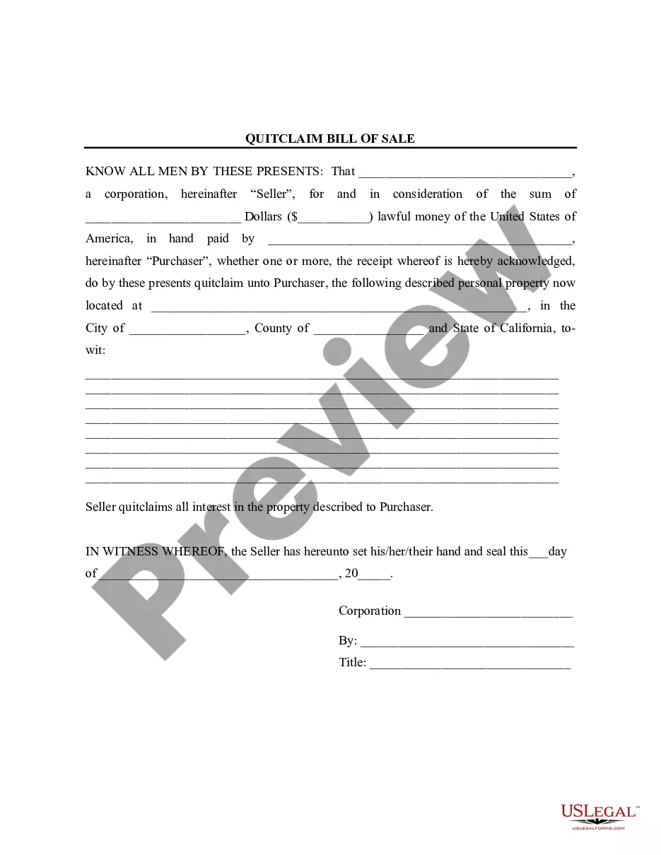
How to fill out Geophysical Permit?
If you need to total, acquire, or produce lawful document layouts, use US Legal Forms, the largest collection of lawful forms, which can be found on the Internet. Make use of the site`s easy and practical research to discover the papers you will need. Numerous layouts for enterprise and specific purposes are sorted by classes and suggests, or key phrases. Use US Legal Forms to discover the North Carolina Geophysical Permit in a couple of mouse clicks.
In case you are currently a US Legal Forms customer, log in to the profile and click the Download key to get the North Carolina Geophysical Permit. You can also accessibility forms you previously acquired within the My Forms tab of your own profile.
If you work with US Legal Forms initially, refer to the instructions below:
- Step 1. Be sure you have selected the form to the appropriate area/nation.
- Step 2. Make use of the Review solution to examine the form`s articles. Do not neglect to learn the explanation.
- Step 3. In case you are not satisfied together with the develop, utilize the Lookup field at the top of the monitor to locate other models of the lawful develop format.
- Step 4. When you have found the form you will need, go through the Buy now key. Choose the prices program you prefer and put your accreditations to register to have an profile.
- Step 5. Approach the deal. You may use your bank card or PayPal profile to complete the deal.
- Step 6. Select the structure of the lawful develop and acquire it in your device.
- Step 7. Complete, modify and produce or indication the North Carolina Geophysical Permit.
Every lawful document format you purchase is your own for a long time. You possess acces to every single develop you acquired inside your acccount. Click the My Forms portion and decide on a develop to produce or acquire once again.
Be competitive and acquire, and produce the North Carolina Geophysical Permit with US Legal Forms. There are millions of skilled and state-specific forms you may use to your enterprise or specific requires.
Form popularity
FAQ
North Carolina has a Graduated Driver License process for anyone under the age of 18. To begin the process, you will enroll in a driver education class. After you have completed the class and the behind-the-wheel training, you will go to any NC DMV office and test for a permit.
Where can I apply for a tundra swan permit? You can apply online at .GoOutdoorsNorthCarolina.com, by calling 833-950-0575, Monday-Friday, 8 a.m.?5 p.m., or at a wildlife service agent. The application deadline is October 1.
Geophysical surveys are completed for a variety of reasons, from archaeological purposes to geological and mining. Archeologists will use geophysical surveys such as ground-penetrating radar (GPR) and magnetometers to identify subsurface artifacts such as underwater shipwrecks or underground burials. What Are Geophysical Surveys & Why Do They Matter rangefront.com ? blog ? what-are-geophysic... rangefront.com ? blog ? what-are-geophysic...
General Offshore Geophysical Survey Permit This nonexclusive permit authorizes geophysical survey activity during the permit term. A General Offshore Geophysical Survey Permit is required for geophysical surveys utilizing low-energy equipment conducted in marine waters under the jurisdiction of the Commission.
In order to proceed with clearing the land and/or engaging in land-disturbing activity, the landowner is required to obtain a Clear-Cutting Permit and is limited on the area in which trees may be removed: Trees proposed for removal may not be located in areas off limit to development; specimen trees must be identified ...
Geophysical data is used to provide information on the physical properties of the Earth's surface and subsurface. As a result, geophysical data can help locate hydrocarbons, minerals, aggregate, and other natural resources. Uses for Geophysical Data alaska.gov ? geophysics ? uses alaska.gov ? geophysics ? uses