Seismic Data and Operations
What is this form?
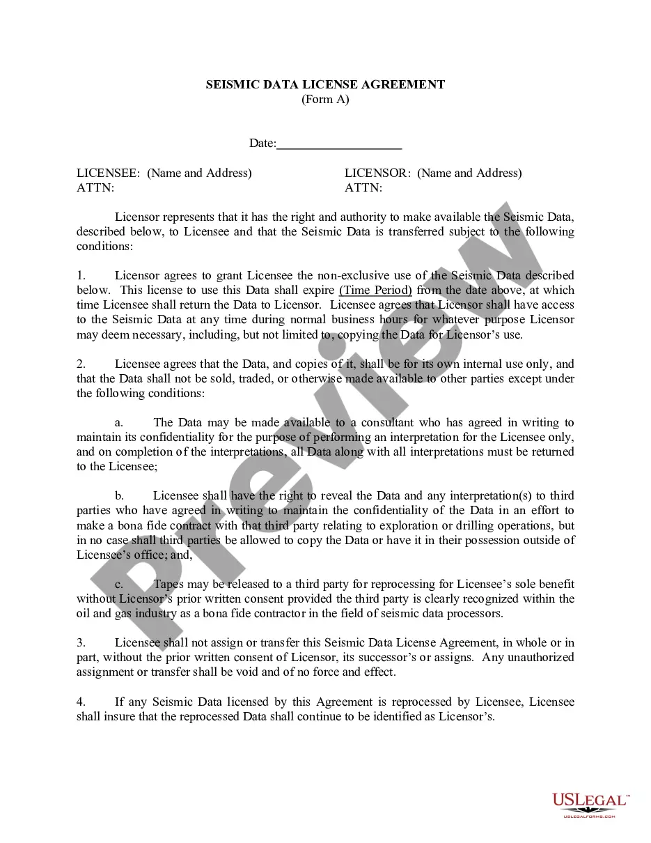
The Seismic Data and Operations form is a legal document used when parties agree to share all proprietary and non-proprietary seismic data related to a designated Contract Area. This agreement enables parties to exchange critical geological information while maintaining rights to sell or market their data independently. Unlike other agreements that may focus solely on data ownership or licensing, this form specifically addresses the sharing and operational use of seismic data, balancing collaboration and proprietary rights among the involved parties.
Form components explained
- Definition of proprietary and non-proprietary seismic data.
- Agreement on data contribution from both parties as of the effective date.
- Provisions regarding confidentiality and licensing restrictions.
- Rights of each party to sell and market previously owned seismic data.
- Allocation of benefits or monetary consideration derived from data transactions.


When this form is needed
This form should be used when two or more parties agree to share seismic data relevant to a particular Contract Area. It is particularly useful in the energy, mining, or geological exploration sectors where collaboration is necessary for resource assessment. Use this form when parties need a clear agreement on data sharing without compromising individual rights to pre-owned data.
Who this form is for
- Energy companies collaborating on resource exploration.
- Geologists and researchers sharing data for study purposes.
- Mining or drilling companies involved in joint operations.
- Consultants or legal advisors in the energy sector seeking to formalize data sharing agreements.
Completing this form step by step
- Identify the parties involved in the agreement.
- Clearly define the proprietary and non-proprietary data to be contributed.
- Specify any confidentiality agreements that may restrict certain data.
- Include the effective date of the agreement.
- Outline the rights of each party to market their respective data.
Notarization guidance
This form does not typically require notarization to be legally valid. However, some jurisdictions or document types may still require it. US Legal Forms provides secure online notarization powered by Notarize, available 24/7 for added convenience.
Get your form ready online
Our built-in tools help you complete, sign, share, and store your documents in one place.
Make edits, fill in missing information, and update formatting in US Legal Forms—just like you would in MS Word.
Download a copy, print it, send it by email, or mail it via USPS—whatever works best for your next step.
Sign and collect signatures with our SignNow integration. Send to multiple recipients, set reminders, and more. Go Premium to unlock E-Sign.
If this form requires notarization, complete it online through a secure video call—no need to meet a notary in person or wait for an appointment.
We protect your documents and personal data by following strict security and privacy standards.

Make edits, fill in missing information, and update formatting in US Legal Forms—just like you would in MS Word.

Download a copy, print it, send it by email, or mail it via USPS—whatever works best for your next step.

Sign and collect signatures with our SignNow integration. Send to multiple recipients, set reminders, and more. Go Premium to unlock E-Sign.

If this form requires notarization, complete it online through a secure video call—no need to meet a notary in person or wait for an appointment.

We protect your documents and personal data by following strict security and privacy standards.
Common mistakes to avoid
- Failing to adequately define what constitutes proprietary and non-proprietary data.
- Not including specific confidentiality clauses, leading to potential legal disputes.
- Overlooking to specify the effective date, which can create confusion regarding the timeline.
Benefits of using this form online
- Convenience of downloading and printing the form at your convenience.
- Editability allows you to customize the form according to your specific needs.
- Reliable templates drafted by licensed attorneys ensure legal compliance.
Looking for another form?


Form popularity
FAQ
Seismic acquisition requires the use of a seismic source at specified locations for a seismic survey, and the energy that travels within the subsurface as seismic waves generated by the source gets recorded at specified locations on the surface by what is known as receivers (geophones or hydrophones).
A seismic survey is a low impact, non-invasive method of gathering information about the location and characteristics of geological structures beneath the Earth's surface.This plate generates an acoustic sound signal that is transmitted into the earth's surface which then reflects off the various geological layers.
Seismic data are used by reservoir management teams to plan and monitor the development and production of a field. Seismic data have the potential to provide the bridge between well logs and core analysis on the one hand, and tracer and well-test analysis on the other.
A seismic operation is conducted by sending a seismic wave into the ground and recording the reflected energy back at the surface. The recorded data needs to go under processing in order to be ready for interpretation.
There are three primary steps in processing seismic data deconvolution, stacking, and migration, in their usual order of application.Deconvolution achieves this goal by compressing the wavelet. Stacking also is a process of compression (velocity analysis and statics corrections).
Seismic images are produced by generating, recording, and analyzing sound waves that travel through the Earth (such waves are also called seismic waves). Explosives or vibrating plates generate the waves and a line or grid of geophones records them.
Seismic surveys use reflected sound waves to produce a CAT scan of the Earth's subsurface. Seismic surveys can help locate ground water, are used to investigate locations for landfills, and characterize how an area will shake during an earthquake, but they are primarily used for oil and gas exploration.
The seismic testing is carried out by a specially configured truck (called a vibroseis truck) that lowers a plate onto the surface.This plate generates an acoustic sound signal that is transmitted into the earth's surface which then reflects off the various geological layers.
Seismic surveys have become the primary tool of exploration companies in the continental United States, both onshore and offshore.The seismic wave travels into the earth, is reflected by subsurface formations, and returns to the surface where it is recorded by receivers called geophones similar to microphones.