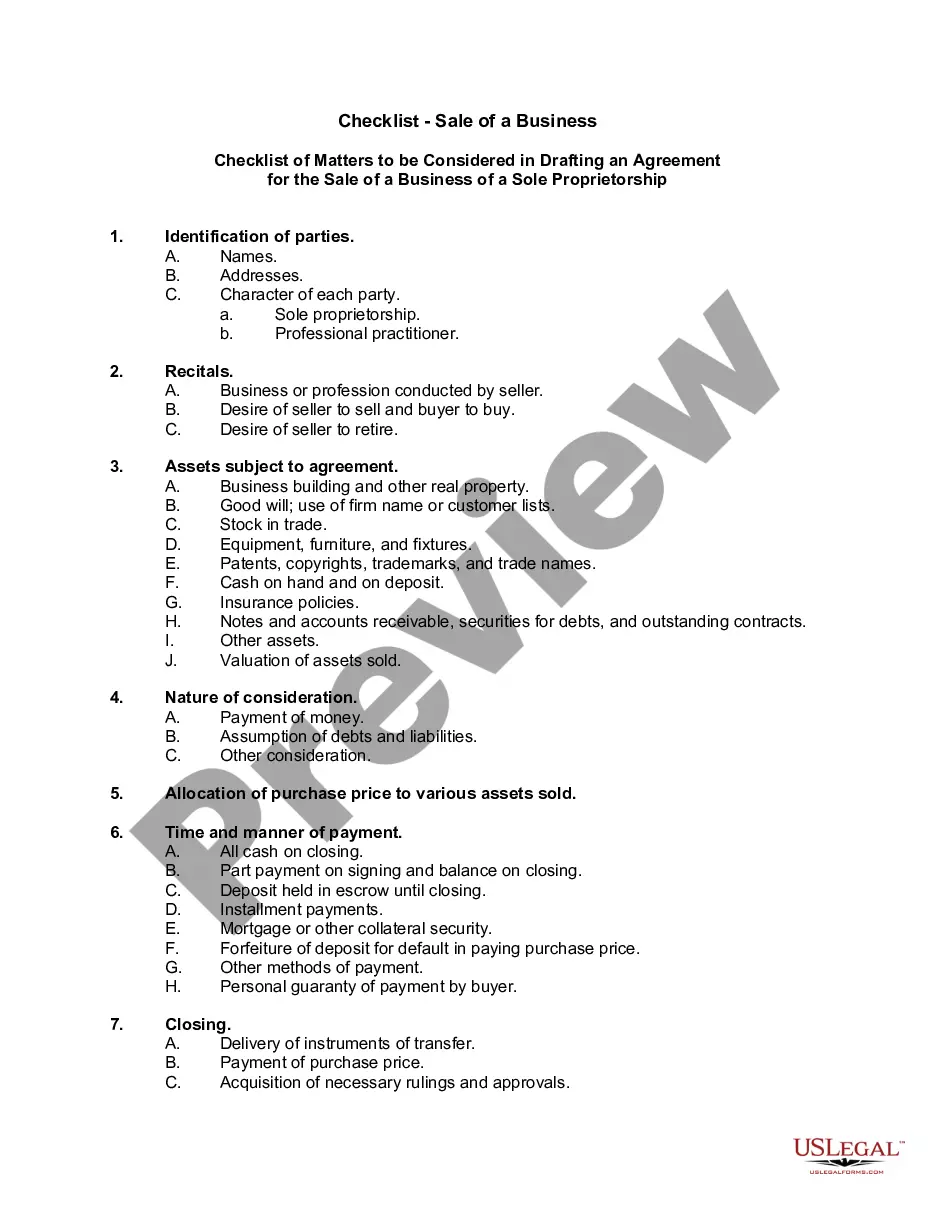
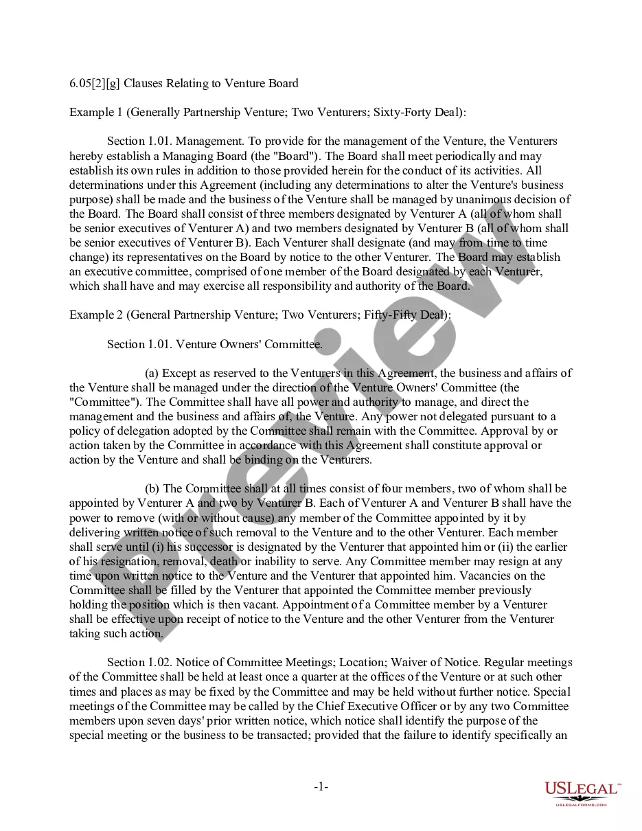
This lease rider form may be used when you are involved in a lease transaction, and have made the decision to utilize the form of Oil and Gas Lease presented to you by the Lessee, and you want to include additional provisions to that Lease form to address specific concerns you may have, or place limitations on the rights granted the Lessee in the “standard” lease form.
New Hampshire Geophysical and Seismic Operations
Category:
State:
Multi-State
Control #:
US-OG-800
Format:
Word;
Rich Text
Instant download
Description
Free preview


Get your form ready online
Our built-in tools help you complete, sign, share, and store your documents in one place.
Built-in online Word editor
Make edits, fill in missing information, and update formatting in US Legal Forms—just like you would in MS Word.
Export easily
Download a copy, print it, send it by email, or mail it via USPS—whatever works best for your next step.
E-sign your document
Sign and collect signatures with our SignNow integration. Send to multiple recipients, set reminders, and more. Go Premium to unlock E-Sign.
Notarize online 24/7
If this form requires notarization, complete it online through a secure video call—no need to meet a notary in person or wait for an appointment.
Store your document securely
We protect your documents and personal data by following strict security and privacy standards.

Make edits, fill in missing information, and update formatting in US Legal Forms—just like you would in MS Word.

Download a copy, print it, send it by email, or mail it via USPS—whatever works best for your next step.

Sign and collect signatures with our SignNow integration. Send to multiple recipients, set reminders, and more. Go Premium to unlock E-Sign.

If this form requires notarization, complete it online through a secure video call—no need to meet a notary in person or wait for an appointment.

We protect your documents and personal data by following strict security and privacy standards.
Looking for another form?

How to fill out Geophysical And Seismic Operations?
Are you currently within a place where you need to have paperwork for possibly company or personal purposes just about every day? There are a variety of legitimate file templates available on the Internet, but discovering kinds you can trust is not simple. US Legal Forms offers a huge number of develop templates, just like the New Hampshire Geophysical and Seismic Operations, which are created to meet federal and state demands.
Should you be previously acquainted with US Legal Forms website and possess your account, simply log in. Next, you are able to acquire the New Hampshire Geophysical and Seismic Operations format.
Unless you have an bank account and need to start using US Legal Forms, follow these steps:
- Obtain the develop you need and ensure it is for that proper town/area.
- Utilize the Review button to examine the shape.
- Read the explanation to ensure that you have chosen the proper develop.
- If the develop is not what you`re trying to find, take advantage of the Lookup area to get the develop that suits you and demands.
- Whenever you discover the proper develop, just click Get now.
- Pick the costs prepare you want, submit the specified info to make your money, and buy an order utilizing your PayPal or Visa or Mastercard.
- Choose a practical paper structure and acquire your duplicate.
Get all the file templates you have purchased in the My Forms menus. You can obtain a more duplicate of New Hampshire Geophysical and Seismic Operations at any time, if necessary. Just click on the necessary develop to acquire or printing the file format.
Use US Legal Forms, by far the most comprehensive collection of legitimate kinds, to save time and stay away from mistakes. The service offers skillfully created legitimate file templates that you can use for a selection of purposes. Make your account on US Legal Forms and initiate generating your lifestyle easier.
Form popularity
FAQ
Some geophysical methods, such as gamma-ray spectrometry and remote sensing, measure surface attributes; others, such as thermal and some electrical methods are limited to detecting relatively shallow features but may help identify features at greater depth.
Geophysical Investigation Methods Seismic Survey. A seismic survey involves the detection of the earth's vibrations and waves. ... Ground Penetrating Radar. Ground-penetrating radar(GPR) utilizes a radar system. ... Magnetic Survey. ... Radiometric Survey.
Geophysical methods measure physical properties of materials that can be used to infer information about the surface and subsurface of the Earth.
These methods are: Gravity method. Seismic method. Electromagnetic method. Geothermal method. Magnetic method. Electrical method. Radiometric method.
Some of the geophysical methods commonly used are seismic refraction and reflection, crosshole testing, downhole testing, spectral analysis of surface waves (SASW), ground penetrating radar (GPR), electromagnetic wave measurement and induced polarization.
From the Ground: Typical geophysical methods collected from the ground include gravity, electromagnetic, magnetotellurics, magnetic, and limited industry seismic-reflection.