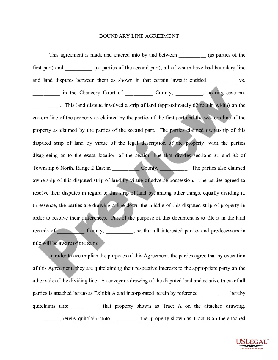
Mississippi Boundary Line Agreement
About this form
The Boundary Line Agreement is a legal document designed for parties in Mississippi who have disputes over the exact boundary line between their properties. This form is essential for clearly defining the agreed-upon boundaries, allowing involved parties to put their agreement in writing. Unlike other land agreements, this specific form is tailored to resolve conflicts that may arise regarding property demarcations and helps prevent future disputes by documenting the resolution.
Key components of this form
- Identification of the parties involved in the boundary line dispute.
- A description of the disputed strip of land and its legal context.
- Details on the agreed resolution, including the division of the disputed land.
- Quitclaim statements transferring property interests based on the agreed boundaries.
- Inclusion of a surveyor's drawing as an exhibit, detailing property lines.
- Execution section with dates and signatures for legal validation.


When to use this form
This form is applicable when two or more property owners have a disagreement regarding the boundary lines separating their respective properties. It is especially useful following a lawsuit that identifies a dispute over land ownership or when the parties want to clarify their property rights to prevent future conflicts. If there is a need to formalize an agreement about dividing disputed land, this form should be utilized.
Who should use this form
- Property owners involved in a boundary dispute in Mississippi.
- Individuals seeking to formalize an agreement to avoid future conflicts over property lines.
- Parties who have already reached an agreement through negotiation or legal proceedings.
How to prepare this document
- Identify all parties involved in the boundary dispute by filling in their names.
- Clearly describe the disputed property, including relevant legal descriptions and dimensions.
- Outline the agreed-upon resolution for the boundary line, specifying how the land will be divided.
- Include the surveyor's drawing as an exhibit to visually represent the property divisions.
- Ensure all parties sign and date the agreement to formalize the document legally.
Does this document require notarization?
To make this form legally binding, it must be notarized. Our online notarization service, powered by Notarize, lets you verify and sign documents remotely through an encrypted video session.
Get your form ready online
Our built-in tools help you complete, sign, share, and store your documents in one place.
Make edits, fill in missing information, and update formatting in US Legal Forms—just like you would in MS Word.
Download a copy, print it, send it by email, or mail it via USPS—whatever works best for your next step.
Sign and collect signatures with our SignNow integration. Send to multiple recipients, set reminders, and more. Go Premium to unlock E-Sign.
If this form requires notarization, complete it online through a secure video call—no need to meet a notary in person or wait for an appointment.
We protect your documents and personal data by following strict security and privacy standards.

Make edits, fill in missing information, and update formatting in US Legal Forms—just like you would in MS Word.

Download a copy, print it, send it by email, or mail it via USPS—whatever works best for your next step.

Sign and collect signatures with our SignNow integration. Send to multiple recipients, set reminders, and more. Go Premium to unlock E-Sign.

If this form requires notarization, complete it online through a secure video call—no need to meet a notary in person or wait for an appointment.

We protect your documents and personal data by following strict security and privacy standards.
Common mistakes
- Failing to accurately describe the disputed land, which can lead to future misunderstandings.
- Not including a surveyor's drawing, which is crucial for visual clarity.
- Incomplete or missing signatures from all parties, rendering the agreement invalid.
Benefits of completing this form online
- Convenient access to legal documents without the need for physical visits to a law office.
- Editable templates allow for customization based on specific dispute details.
- Assurance that the forms are up-to-date with the latest legal requirements in Mississippi.
What to keep in mind
- A Boundary Line Agreement is essential for resolving property boundary disputes.
- This form is specific to Mississippi law and must follow state requirements.
- Proper completion and documentation, including signatures and survey drawings, are crucial.
Looking for another form?


Form popularity
FAQ
Your jurisdiction may have laws about how far back a fence needs to be set on your property, which is typically 2, 4, 6 or 8 inches from the property line. Other areas will allow you to go right up to the property line.
Boundary responsibility is always mentioned in the Deeds and if it is not then they are party boundaries. Often boundaries are not marked out in terms of precise measurements. The Land Registry Title Plans are always to scale. However, you cannot rely upon this as an accurate measurement to determine the boundaries.
As a last resort, if you feel confident that your property is being encroached upon, you can file a claim in court and ask a judge to decide the boundariesbut the more you involve the legal system, the more cost you will incur.
Use the Go To command on your GPS to navigate to each waypoint marking the corner of your land. Please realize that there are limits to the accuracy of your GPS receiver. This technique should get you within a few feet of a property corner and will help you narrow down where to search to find missing survey monuments.
Taking the details from the legal description and plat map, a surveyor carefully measures the legal boundaries of your property. The surveyor will bury survey pins if they're not already there and often mark the spots with stakes or flags for easy use.
The doctrine provides that when two adjacent owners who are uncertain of the true position of the common boundary between the parcels agree to the true position of the common boundary, mark it on the ground or build it up, and occupy each side for a period equal to the statute of limitations, then such line becomes the
Google Maps will display property lines if you type your address into the 'Search Google Maps' search bar and zoom into the property closely enough. However, property lines are not available on all locations in Google Maps, unfortunately.
Find your property line by visiting your local county recorder or assessor's office. You can access public maps of your street and locate your boundaries. Many counties also let you access property lines online. If your property is on platted land, you may be able to access the plat maps online.
1. Side and Rear Yards. Yard structures under six feet in height may be located up to a side or rear property line subject to building code and fire code limitations. Yard structures six feet in height or over shall be located at least three feet from any property line and shall not exceed 12 feet in height.