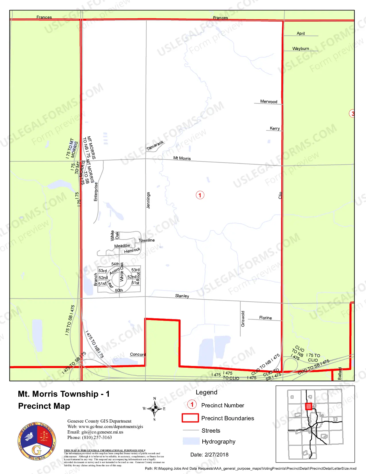
The Michigan Genesee County 2018 Voting Precincts COMMUNITY Map Book 32×44 inches 12MOBBB) is an interactive map that provides an up-to-date picture of the 2018 Voting Precincts in Genesee County, Michigan. This resource provides detailed information on the locations of the precincts and the boundaries of each. The map book also includes information about the population and demographics of the county, as well as key points of interest in the area. The map book is available in two formats: digital (PDF) and hard copy (32×44 inches). The digital version is 12 MB and is best viewed on a desktop or laptop computer. The hard copy version is printed on high-quality paper and is ideal for displaying in offices, schools, or other locations. The map book also includes detailed descriptions of the election districts, and an index of key election officials and information about the voting process.
Michigan Genesee County 2018 Voting Precincts COMMUNITY Map Book 32x44 inches (12MB)
Description
")
")
")
Get your form ready online
Our built-in tools help you complete, sign, share, and store your documents in one place.
Make edits, fill in missing information, and update formatting in US Legal Forms—just like you would in MS Word.
Download a copy, print it, send it by email, or mail it via USPS—whatever works best for your next step.
Sign and collect signatures with our SignNow integration. Send to multiple recipients, set reminders, and more. Go Premium to unlock E-Sign.
If this form requires notarization, complete it online through a secure video call—no need to meet a notary in person or wait for an appointment.
We protect your documents and personal data by following strict security and privacy standards.

Make edits, fill in missing information, and update formatting in US Legal Forms—just like you would in MS Word.

Download a copy, print it, send it by email, or mail it via USPS—whatever works best for your next step.

Sign and collect signatures with our SignNow integration. Send to multiple recipients, set reminders, and more. Go Premium to unlock E-Sign.

If this form requires notarization, complete it online through a secure video call—no need to meet a notary in person or wait for an appointment.

We protect your documents and personal data by following strict security and privacy standards.
Looking for another form?


How to fill out Michigan Genesee County 2018 Voting Precincts COMMUNITY Map Book 32x44 Inches (12MB)?
Creating formal documents can be a significant hassle unless you possess ready-to-use fillable templates. With the US Legal Forms online collection of official documentation, you can be assured about the information you enter, as all documents align with federal and state laws and are verified by our experts.
So if you need to download the Michigan Genesee County 2018 Voting Precincts COMMUNITY Map Book 32x44 inches (12MB), our service is the ideal place.
Here’s a quick guide for you: Document compliance evaluation. You should carefully examine the content of the form you desire and ensure it meets your needs and adheres to your state law standards. Previewing your document and checking its general description will assist you in this process. Alternative search (optional). If you discover any discrepancies, explore the library using the Search tab above until you find an appropriate blank, and click Buy Now when you identify the one you prefer. Account registration and form acquisition. Sign up for an account with US Legal Forms. After confirming your account, Log In and select your desired subscription plan. Make a payment to continue (PayPal and credit card options are available). Template download and subsequent use. Choose the file type for your Michigan Genesee County 2018 Voting Precincts COMMUNITY Map Book 32x44 inches (12MB) and click Download to save it on your device. Print it to complete your paperwork manually or utilize a multifunctional online editor to prepare an electronic copy more swiftly and efficiently.
- Acquiring your Michigan Genesee County 2018 Voting Precincts COMMUNITY Map Book 32x44 inches (12MB) from our library is as simple as A-B-C.
- Previously authorized users with a valid subscription need only Log In and click the Download button once they find the appropriate template.
- Subsequently, if necessary, users can retrieve the same document from the My documents section of their profile.
- However, even if you are not familiar with our service, registering with a valid subscription will only take a moment.
Form popularity
FAQ
Polling places and the poll workers who run them are the front lines of American elections. ing to the EAVS, during the 2016 elections, local election officials operated 116,990 polling places, including 8,616 early voting locations, across the country.
The terms (election) precinct and election district are more common in American English. In Canadian English, the term is used, especially officially, but is also colloquially and more commonly known as a riding or constituency.
Proportional systems Party-list proportional representation is the single most common electoral system and is used by 80 countries, and involves voters voting for a list of candidates proposed by a party.
Turnout statistics ElectionVoting-age population (VAP)Turnout as % of VAP2008229,945,00057.1%2012235,248,00053.8%2016249,422,00054.8%2020257,605,08862.0%19 more rows
Kansas had the smallest average precinct size with 437 voters per precinct, while the District of Columbia had the largest average size at 2,704 voters per precinct.
16-years-old is the lowest minimum age globally for national elections, while the highest is 25-years-old which is only the case in the United Arab Emirates (UAE). This age of 25 was also the case in Italy for Senate (upper house) elections until it was lowered to 18 in 2021.