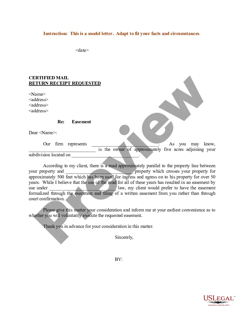
North Dakota Sample Letter regarding Survey Maps
Description
Get your form ready online
Our built-in tools help you complete, sign, share, and store your documents in one place.
Make edits, fill in missing information, and update formatting in US Legal Forms—just like you would in MS Word.
Download a copy, print it, send it by email, or mail it via USPS—whatever works best for your next step.
Sign and collect signatures with our SignNow integration. Send to multiple recipients, set reminders, and more. Go Premium to unlock E-Sign.
If this form requires notarization, complete it online through a secure video call—no need to meet a notary in person or wait for an appointment.
We protect your documents and personal data by following strict security and privacy standards.

Make edits, fill in missing information, and update formatting in US Legal Forms—just like you would in MS Word.

Download a copy, print it, send it by email, or mail it via USPS—whatever works best for your next step.

Sign and collect signatures with our SignNow integration. Send to multiple recipients, set reminders, and more. Go Premium to unlock E-Sign.

If this form requires notarization, complete it online through a secure video call—no need to meet a notary in person or wait for an appointment.

We protect your documents and personal data by following strict security and privacy standards.
Looking for another form?


How to fill out Sample Letter Regarding Survey Maps?
US Legal Forms - among the largest libraries of legal varieties in the United States - delivers an array of legal record themes it is possible to acquire or produce. Utilizing the website, you can get thousands of varieties for company and personal purposes, sorted by classes, says, or search phrases.You will find the newest versions of varieties just like the North Dakota Sample Letter regarding Survey Maps in seconds.
If you have a subscription, log in and acquire North Dakota Sample Letter regarding Survey Maps through the US Legal Forms local library. The Down load button will show up on each and every develop you look at. You have accessibility to all earlier acquired varieties inside the My Forms tab of your profile.
In order to use US Legal Forms the very first time, listed here are basic instructions to obtain began:
- Ensure you have chosen the best develop for your area/region. Go through the Review button to analyze the form`s content. See the develop description to actually have selected the appropriate develop.
- In case the develop does not fit your specifications, make use of the Lookup field on top of the display to obtain the one that does.
- Should you be happy with the shape, verify your decision by clicking on the Buy now button. Then, choose the rates prepare you prefer and supply your references to sign up for the profile.
- Process the financial transaction. Make use of your Visa or Mastercard or PayPal profile to accomplish the financial transaction.
- Pick the structure and acquire the shape on your own product.
- Make alterations. Load, modify and produce and signal the acquired North Dakota Sample Letter regarding Survey Maps.
Each and every template you included with your bank account does not have an expiry particular date and it is your own property forever. So, if you would like acquire or produce yet another backup, just visit the My Forms segment and then click in the develop you want.
Gain access to the North Dakota Sample Letter regarding Survey Maps with US Legal Forms, one of the most considerable local library of legal record themes. Use thousands of professional and status-particular themes that meet up with your business or personal requirements and specifications.
Form popularity
FAQ
North Dakota leads the nation in production of spring wheat, durum wheat, dry edible peas, dry edible beans, honey, flaxseed and canola. North Dakota is the No. 1 producer of honey in the nation.
North Dakota is bordered by Canada in the north, Minnesota in the east, South Dakota in the south, and Montana in the west. Elevation rises from east to west as the Rocky Mountains appear.
North Dakota / Canadian Border Crossings North Dakota's 310-mile northern border has 18 international ports that are shared with the Canadian provinces of Saskatchewan and Manitoba.
Along the rugged 360-mile border between North Dakota and South Dakota there once stood 720 quartzite markers, cut from the quarries near Sioux Falls and placed there in 1891 and 1892 by United States surveyor Charles H. Bates and his crew. In "The Quartzite Border," Dr. Gordon L.
The winding Red River of the North shapes its border with Minnesota in the east. The territory of today's North Dakota was acquired partly by the Louisiana Purchase in 1803, and partly from Great Britain by a treaty in 1818.
It is bordered by the Canadian provinces of Saskatchewan and Manitoba to the north and by the U.S. states of Minnesota to the east, South Dakota to the south, and Montana to the west.
The boundary between North Dakota and Minnesota, the thread of the channels of the Red River of the North and the Bois de Sioux River, is approximately 434 miles long. The "as-the-crow-flies" distance is about 213 miles.