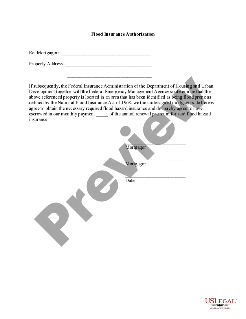
Indiana Flood Zone Statement and Authorization
The Flood Zone Statement and Authorization form is a legal document that sellers use to disclose the flood zone status of a property. This form allows buyers to acknowledge the disclosed information and agree to obtain flood insurance if the property is later determined to be in a flood zone as defined by the National Flood Insurance Act of 1968. Unlike other property disclosure forms, this specific statement focuses solely on flood zone status and insurance responsibilities.
- Property address section for identifying the location.
- Sellers' declaration to indicate whether the property is in a flood-prone area.
- Buyers' acknowledgment of the propertyâs flood zone status.
- Commitment from buyers to acquire flood insurance if required in the future.
- Signature lines for both sellers and buyers to validate the agreement.


This form should be used during the sale of a property, particularly when the seller must disclose if the property is in a flood zone. It is critical in real estate transactions, as lenders often require a clear understanding of potential flood risks. Use this form when making property transactions in areas prone to flooding or when federal regulations on flood insurance apply.
This form is intended for:
- Sellers of residential or commercial properties.
- Buyers looking to purchase real estate in flood-prone areas.
- Real estate agents facilitating the sale of properties in identified flood zones.
- Banking institutions requiring flood disclosure for mortgage approvals.
To complete this form, follow these steps:
- Identify the property by entering the address in the designated space.
- Sellers must check the appropriate box to indicate their knowledge of the property's flood zone status.
- If applicable, attach any supporting documents, such as a survey or Flood Certification.
- Buyers should read the acknowledgment section carefully and ensure they understand their insurance obligations.
- Provide the required signatures and dates for both sellers and buyers to finalize the document.
This form does not typically require notarization unless specified by local law.
Get your form ready online
Our built-in tools help you complete, sign, share, and store your documents in one place.
Make edits, fill in missing information, and update formatting in US Legal Forms—just like you would in MS Word.
Download a copy, print it, send it by email, or mail it via USPS—whatever works best for your next step.
Sign and collect signatures with our SignNow integration. Send to multiple recipients, set reminders, and more. Go Premium to unlock E-Sign.
If this form requires notarization, complete it online through a secure video call—no need to meet a notary in person or wait for an appointment.
We protect your documents and personal data by following strict security and privacy standards.

Make edits, fill in missing information, and update formatting in US Legal Forms—just like you would in MS Word.

Download a copy, print it, send it by email, or mail it via USPS—whatever works best for your next step.

Sign and collect signatures with our SignNow integration. Send to multiple recipients, set reminders, and more. Go Premium to unlock E-Sign.

If this form requires notarization, complete it online through a secure video call—no need to meet a notary in person or wait for an appointment.

We protect your documents and personal data by following strict security and privacy standards.
- Failing to check the correct box about the flood zone status.
- Not attaching necessary documentation, like Flood Certification.
- Leaving signature lines empty or incorrectly filled out.
- Overlooking dates when signing the form.
- Easy online access makes filling out the form convenient.
- Editable templates allow for customization to specific property needs.
- Provides peace of mind with legally vetted language drafted by licensed attorneys.
- Properly completing this form helps avoid future legal disputes regarding flood insurance responsibilities.
- This form serves as a written record of the flood zone status for legal and financial institutions.
- The Flood Zone Statement and Authorization is essential for real estate transactions in flood-prone areas.
- Both sellers and buyers have specific disclosures and acknowledgments to make regarding flood risk.
- Understanding and correctly completing this form is crucial to comply with federal flood insurance requirements.
Looking for another form?
Form popularity
FAQ
A Flood Zone is a geographical area that is rated to reflect the severity or type of flooding in that area.Areas of minimal flood hazard, Zone C or Zone X are areas outside the SFHA and higher than the elevation of the 0.2-percent-annual-chance flood.
Zone A. Zone A is the flood insurance rate zone that corresponds to the I-percent annual chance floodplains that are determined in the Flood Insurance Study by approximate methods of analysis.
A study in Science Daily confirmed that proximity to a flood zone - adjacent to a floodplain like a stream or river which might flood - can lower your home's property value by about 7.3 percent.
AE flood zones are areas that present a 1% annual chance of flooding and a 26% chance over the life of a 30-year mortgage, according to FEMA.Since these areas are prone to flooding, homeowners with mortgages from federally regulated lenders are required to purchase flood insurance through the NFIP.
Summary: Proximity to a flood zone lowers property values. By law, a property is considered in a flood zone if any part of the structure falls within a floodplain, an area that is adjacent to a stream or river that experiences periodic flooding.
Flood insurance is mandatory in all A zones because of the high potential of flooding. A-zone maps also include AE, AH, AO, AR and A99 designations, all having the same rates.
The 1-percent annual chance flood is also referred to as the base flood or 100-year flood. SFHAs are labeled as Zone A, Zone AO, Zone AH, Zones A1-A30, Zone AE, Zone A99, Zone AR, Zone AR/AE, Zone AR/AO, Zone AR/A1-A30, Zone AR/A, Zone V, Zone VE, and Zones V1-V30.
Flood zones are geographic areas that the FEMA has defined according to varying levels of flood risk. These zones are depicted on a community's Flood Insurance Rate Map (FIRM) or Flood Hazard Boundary Map. Each zone reflects the severity or type of flooding in the area.
Flood Zone A. Areas subject to inundation by the 1-percent-annual-chance flood event generally determined using approximate methodologies. Flood Zone AE, A1-30. Flood Zone AH. Flood Zone AO. Flood Zone AR. Flood Zone A99. Flood Zone V. Flood Zone VE, V1-30.