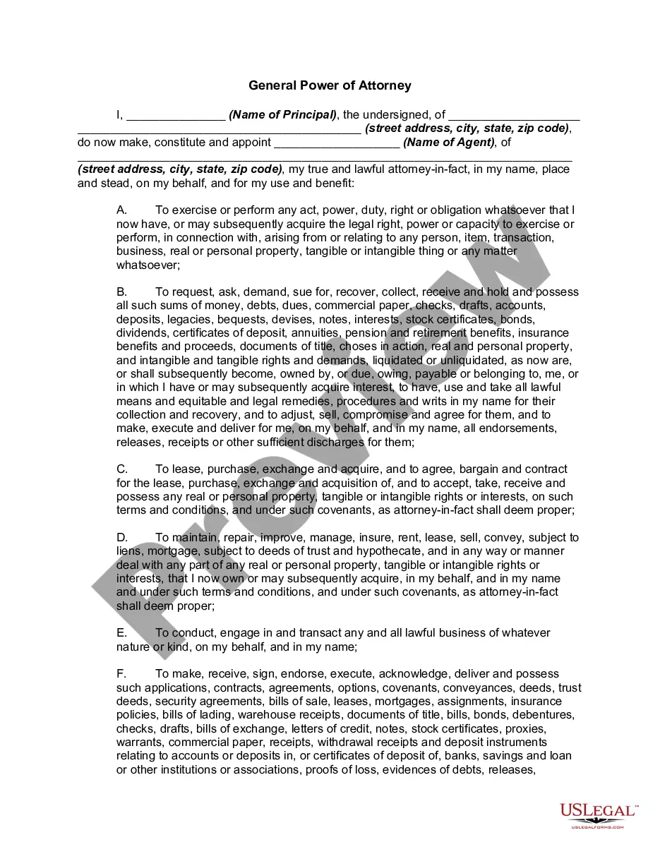
This lease rider form may be used when you are involved in a lease transaction, and have made the decision to utilize the form of Oil and Gas Lease presented to you by the Lessee, and you want to include additional provisions to that Lease form to address specific concerns you may have, or place limitations on the rights granted the Lessee in the “standard” lease form.
West Virginia Geophysical and Seismic Operations
Category:
State:
Multi-State
Control #:
US-OG-800
Format:
Word;
Rich Text
Instant download
Description
Free preview


Get your form ready online
Our built-in tools help you complete, sign, share, and store your documents in one place.
Built-in online Word editor
Make edits, fill in missing information, and update formatting in US Legal Forms—just like you would in MS Word.
Export easily
Download a copy, print it, send it by email, or mail it via USPS—whatever works best for your next step.
E-sign your document
Sign and collect signatures with our SignNow integration. Send to multiple recipients, set reminders, and more. Go Premium to unlock E-Sign.
Notarize online 24/7
If this form requires notarization, complete it online through a secure video call—no need to meet a notary in person or wait for an appointment.
Store your document securely
We protect your documents and personal data by following strict security and privacy standards.
Make edits, fill in missing information, and update formatting in US Legal Forms—just like you would in MS Word.
Download a copy, print it, send it by email, or mail it via USPS—whatever works best for your next step.
Sign and collect signatures with our SignNow integration. Send to multiple recipients, set reminders, and more. Go Premium to unlock E-Sign.

If this form requires notarization, complete it online through a secure video call—no need to meet a notary in person or wait for an appointment.
We protect your documents and personal data by following strict security and privacy standards.
Looking for another form?


How to fill out Geophysical And Seismic Operations?
You may spend hrs on the web trying to find the lawful record template that suits the state and federal specifications you require. US Legal Forms supplies a huge number of lawful types which are examined by pros. It is simple to down load or print the West Virginia Geophysical and Seismic Operations from your support.
If you already have a US Legal Forms bank account, you may log in and then click the Obtain button. After that, you may full, change, print, or indicator the West Virginia Geophysical and Seismic Operations. Each lawful record template you acquire is yours eternally. To get yet another version associated with a obtained form, proceed to the My Forms tab and then click the corresponding button.
If you use the US Legal Forms internet site for the first time, stick to the easy guidelines below:
- Initial, ensure that you have selected the correct record template for that area/city of your choice. Read the form explanation to ensure you have picked the proper form. If accessible, make use of the Review button to look through the record template at the same time.
- If you want to locate yet another model of the form, make use of the Look for area to find the template that suits you and specifications.
- Once you have located the template you want, click Purchase now to move forward.
- Pick the pricing strategy you want, key in your credentials, and sign up for a free account on US Legal Forms.
- Total the financial transaction. You can use your charge card or PayPal bank account to fund the lawful form.
- Pick the structure of the record and down load it to the product.
- Make changes to the record if possible. You may full, change and indicator and print West Virginia Geophysical and Seismic Operations.
Obtain and print a huge number of record layouts making use of the US Legal Forms web site, that offers the biggest collection of lawful types. Use specialist and status-specific layouts to tackle your business or personal demands.
Form popularity
FAQ
Ing to the United States Geological Survey (USGS) Quaternary Faults map, the only area of a fault line in West Virginia is a small section of Class B fault area in the counties of Mercer, Summers and Monroe.
Most earthquakes in Virginia are not associated with a known fault, but occur within three distinct seismic zones: the Eastern Tennessee Seismic Zone (ETSZ) includes Lee County in far southwestern Virginia; the Giles County Seismic Zone (GCSZ) extends through the New River Valley; and the Central Virginia Seismic Zone ...
Movements of the earth's tectonic plates cause episodes of rifting and mountain building. Combined with subsequent erosion, production, and deposition of sediments these mountain-building episodes resulted in the geology of our state.
The New Madrid Seismic Zone This 150 mile-long series of faults stretches under five states: Illinois, Missouri, Arkansas, Tennessee and Kentucky, and is responsible for four of the largest earthquakes in the history of the United States, which took place over three months from December 1811 and February 1812.
?West Virginia is tectonically very stable because it is located far from the plate boundaries and far from major active faults, so earthquakes are rare in the state.
Except for recent alluvial deposits, there are no other known Cenozoic rocks. The oldest evidences of life found in West Virginia occur in rocks about 600 million years old, in the Antietam Formation of Lower Cambrian age.
Thick wedges of sandstone, shale and limestone piled up, all folded by later collisions to the east. Along West Virginia's easternmost border, resistant, tilted sandstones form long ridges that parallel the fold axes, while less folded rock forms the horizontal layers of the Appalachian plateaus to the west.
Yes, there are fault lines that run through the east coast of the United States. Though these faults are older and less active than those on the west coast of the country they can still produce earthquakes.