Virgin Islands Application for Rezoning and / or Future Land Use Map Amendment
Description


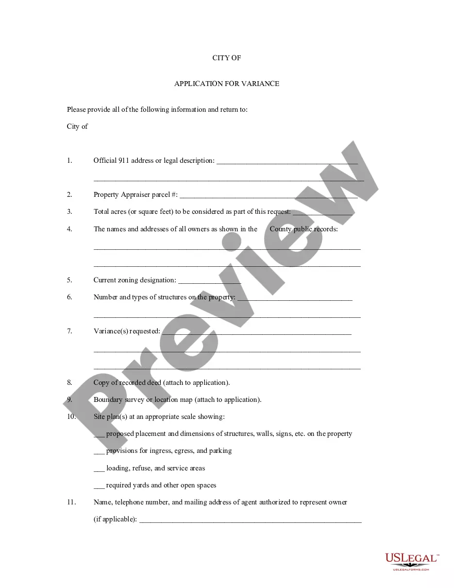
How to fill out Application For Rezoning And / Or Future Land Use Map Amendment?
If you need to complete, down load, or produce legal file templates, use US Legal Forms, the greatest assortment of legal varieties, that can be found online. Utilize the site`s basic and hassle-free research to obtain the paperwork you require. Numerous templates for organization and individual functions are sorted by groups and says, or keywords and phrases. Use US Legal Forms to obtain the Virgin Islands Application for Rezoning and / or Future Land Use Map Amendment in a couple of mouse clicks.
Should you be presently a US Legal Forms consumer, log in in your accounts and then click the Download option to find the Virgin Islands Application for Rezoning and / or Future Land Use Map Amendment. You can even accessibility varieties you earlier delivered electronically inside the My Forms tab of your own accounts.
Should you use US Legal Forms the very first time, follow the instructions under:
- Step 1. Ensure you have chosen the form for the appropriate city/nation.
- Step 2. Use the Review solution to check out the form`s content. Don`t neglect to learn the information.
- Step 3. Should you be not satisfied with the kind, utilize the Research field at the top of the display to locate other types from the legal kind format.
- Step 4. After you have located the form you require, click on the Buy now option. Choose the rates plan you like and put your accreditations to sign up for the accounts.
- Step 5. Procedure the transaction. You can use your bank card or PayPal accounts to perform the transaction.
- Step 6. Select the formatting from the legal kind and down load it in your system.
- Step 7. Full, edit and produce or signal the Virgin Islands Application for Rezoning and / or Future Land Use Map Amendment.
Each legal file format you purchase is your own for a long time. You have acces to every kind you delivered electronically with your acccount. Click the My Forms area and decide on a kind to produce or down load once more.
Remain competitive and down load, and produce the Virgin Islands Application for Rezoning and / or Future Land Use Map Amendment with US Legal Forms. There are many professional and state-specific varieties you can utilize for your personal organization or individual requires.
Form popularity
FAQ
The R-3 Residential zones will provide for medium density hotels and multi-family dwellings and their related needs.
An applicant for permanent residence must reside in the Virgin Islands consecutively for a period of 20 years before application can be considered. An applicant can only be absent from the Territory for 90 days in any calendar year except when pursuing further education or as a result of illness.
INDIVIDUAL INCOME TAX Individuals who are bona fide residents of the Virgin Islands file Form 1040 with the Virgin Islands and pay tax on their worldwide income to the Virgin Islands.
With very few exceptions, most of which have to do with children born to foreign government officials on assignment to the U.S., a person born in any of the fifty states, Guam, Puerto Rico and U.S. Virgin Islands is an American Citizen at birth, under the principle of jus soli, regardless of the nationality of his/her ...
When you are moving to the US Virgin Islands from the USA, if you are an American citizen you will not require a visa. However, non-US citizens willing to stay in the Virgin Islands for a long term need to apply for suitable visas. There are H1B, H2B and student visas available to move to the islands and live there.
An applicant for permanent residence must reside in the Virgin Islands consecutively for a period of 20 years before application can be considered. An applicant can only be absent from the Territory for 90 days in any calendar year except when pursuing further education or as a result of illness.