Oregon Legal Description and Well or Unit Information
Description

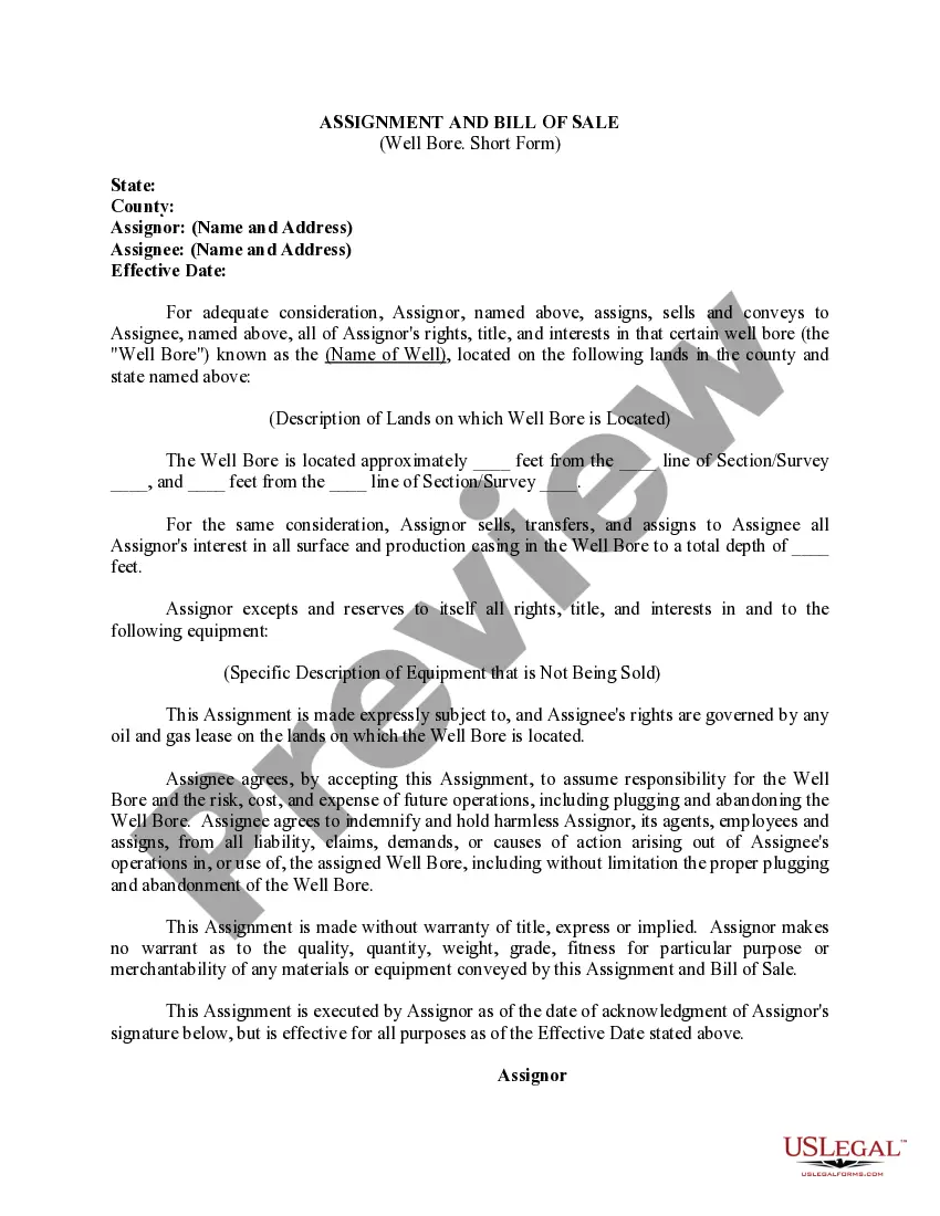
How to fill out Legal Description And Well Or Unit Information?
US Legal Forms - one of many most significant libraries of legal types in the USA - delivers a wide range of legal document layouts it is possible to obtain or print out. While using site, you will get 1000s of types for enterprise and individual uses, categorized by types, claims, or key phrases.You will find the latest models of types like the Oregon Legal Description and Well or Unit Information in seconds.
If you have a registration, log in and obtain Oregon Legal Description and Well or Unit Information from your US Legal Forms library. The Acquire button will show up on each kind you see. You gain access to all formerly saved types within the My Forms tab of the bank account.
If you wish to use US Legal Forms initially, here are straightforward guidelines to help you get began:
- Ensure you have picked out the right kind for the metropolis/area. Click the Preview button to examine the form`s content. See the kind outline to actually have chosen the right kind.
- If the kind doesn`t match your demands, utilize the Search field near the top of the display to get the one that does.
- Should you be content with the form, affirm your decision by simply clicking the Purchase now button. Then, choose the pricing plan you want and offer your credentials to sign up on an bank account.
- Procedure the purchase. Utilize your Visa or Mastercard or PayPal bank account to perform the purchase.
- Find the formatting and obtain the form on the gadget.
- Make alterations. Fill up, change and print out and sign the saved Oregon Legal Description and Well or Unit Information.
Each template you added to your money lacks an expiry particular date and is yours eternally. So, if you wish to obtain or print out one more version, just proceed to the My Forms segment and then click in the kind you want.
Get access to the Oregon Legal Description and Well or Unit Information with US Legal Forms, by far the most considerable library of legal document layouts. Use 1000s of expert and express-certain layouts that meet your organization or individual requirements and demands.
Form popularity
FAQ
Your best bet to finding the legal description is to locate the deed to the property in the public record. You can visit your county clerk of the court's website or office to find the deed. Most counties have this information online, and you can search by address, owner name, or parcel number.
Real property may be described by giving the subdivision ing to the United States survey when coincident with the boundaries thereof, or by lots, blocks and addition names, or by giving the boundaries thereof by metes and bounds, or by reference to the book and page of any public record of the county where the ...
The Oregon Department of Environmental Quality (DEQ), in partnership with many other agencies, has the primary responsibility for Oregon's groundwater protection program. DEQ uses a variety of regulatory and voluntary programs to protect the state's groundwater.
Under Oregon law, ?all water within the state from all sources of water supply belongs to the public.? In general you must obtain a water right permit before using water from any well. However, there are exceptions called ?exempt uses? (see ORS 537.545).
307.010 Definition of real property and land. (1)(b) Real property includes: (A) the land itself, above or under water; (B) all buildings, structures, improvements, machinery, equipment or fixtures erected upon, above or affixed to the land[.]
The Water Resources Department maintains a database of most wells constructed in the state since approximately 1960. Use this database to search for a well report, also known as a well log.
A legal description is the precise location and measurement of real property. While an address is often used to locate a property, legal descriptions are used when transferring title because they're more accurate. Unlike an address, it's a unique identifier.
A legal description is a written recorded document defining the boundaries of a property. The legal description must contain, at the very least, the city and county the property is located in. In practice, the description has to contain enough information so that a surveyor can reliably determine the boundaries later.