Maryland Boundary Line Agreement and Deed Between Adjacent Land Owners
Description


Get your form ready online
Our built-in tools help you complete, sign, share, and store your documents in one place.
Make edits, fill in missing information, and update formatting in US Legal Forms—just like you would in MS Word.
Download a copy, print it, send it by email, or mail it via USPS—whatever works best for your next step.
Sign and collect signatures with our SignNow integration. Send to multiple recipients, set reminders, and more. Go Premium to unlock E-Sign.
If this form requires notarization, complete it online through a secure video call—no need to meet a notary in person or wait for an appointment.
We protect your documents and personal data by following strict security and privacy standards.

Make edits, fill in missing information, and update formatting in US Legal Forms—just like you would in MS Word.

Download a copy, print it, send it by email, or mail it via USPS—whatever works best for your next step.

Sign and collect signatures with our SignNow integration. Send to multiple recipients, set reminders, and more. Go Premium to unlock E-Sign.

If this form requires notarization, complete it online through a secure video call—no need to meet a notary in person or wait for an appointment.

We protect your documents and personal data by following strict security and privacy standards.
Looking for another form?

How to fill out Boundary Line Agreement And Deed Between Adjacent Land Owners?
It is possible to invest several hours on the Internet looking for the lawful record format that meets the state and federal needs you want. US Legal Forms offers 1000s of lawful forms which are reviewed by specialists. You can actually down load or print out the Maryland Boundary Line Agreement and Deed Between Adjacent Land Owners from our service.
If you already possess a US Legal Forms profile, you can log in and click the Obtain button. Next, you can full, modify, print out, or signal the Maryland Boundary Line Agreement and Deed Between Adjacent Land Owners. Every single lawful record format you purchase is your own property for a long time. To get yet another version associated with a obtained kind, proceed to the My Forms tab and click the corresponding button.
Should you use the US Legal Forms site for the first time, stick to the basic directions beneath:
- Initial, make sure that you have chosen the best record format for that county/area of your choosing. See the kind outline to ensure you have chosen the appropriate kind. If accessible, use the Preview button to check from the record format also.
- If you wish to locate yet another edition in the kind, use the Search field to find the format that suits you and needs.
- After you have found the format you would like, just click Acquire now to move forward.
- Find the costs plan you would like, key in your references, and sign up for an account on US Legal Forms.
- Total the purchase. You should use your Visa or Mastercard or PayPal profile to pay for the lawful kind.
- Find the format in the record and down load it to your product.
- Make alterations to your record if required. It is possible to full, modify and signal and print out Maryland Boundary Line Agreement and Deed Between Adjacent Land Owners.
Obtain and print out 1000s of record themes making use of the US Legal Forms Internet site, that offers the most important selection of lawful forms. Use professional and state-certain themes to tackle your small business or specific needs.
Form popularity
FAQ
In international law, national boundary delimitation (also known as national delimitation and boundary delimitation) is the process of legally establishing the outer limits ("borders") of a state within which full territorial or functional sovereignty is exercised.
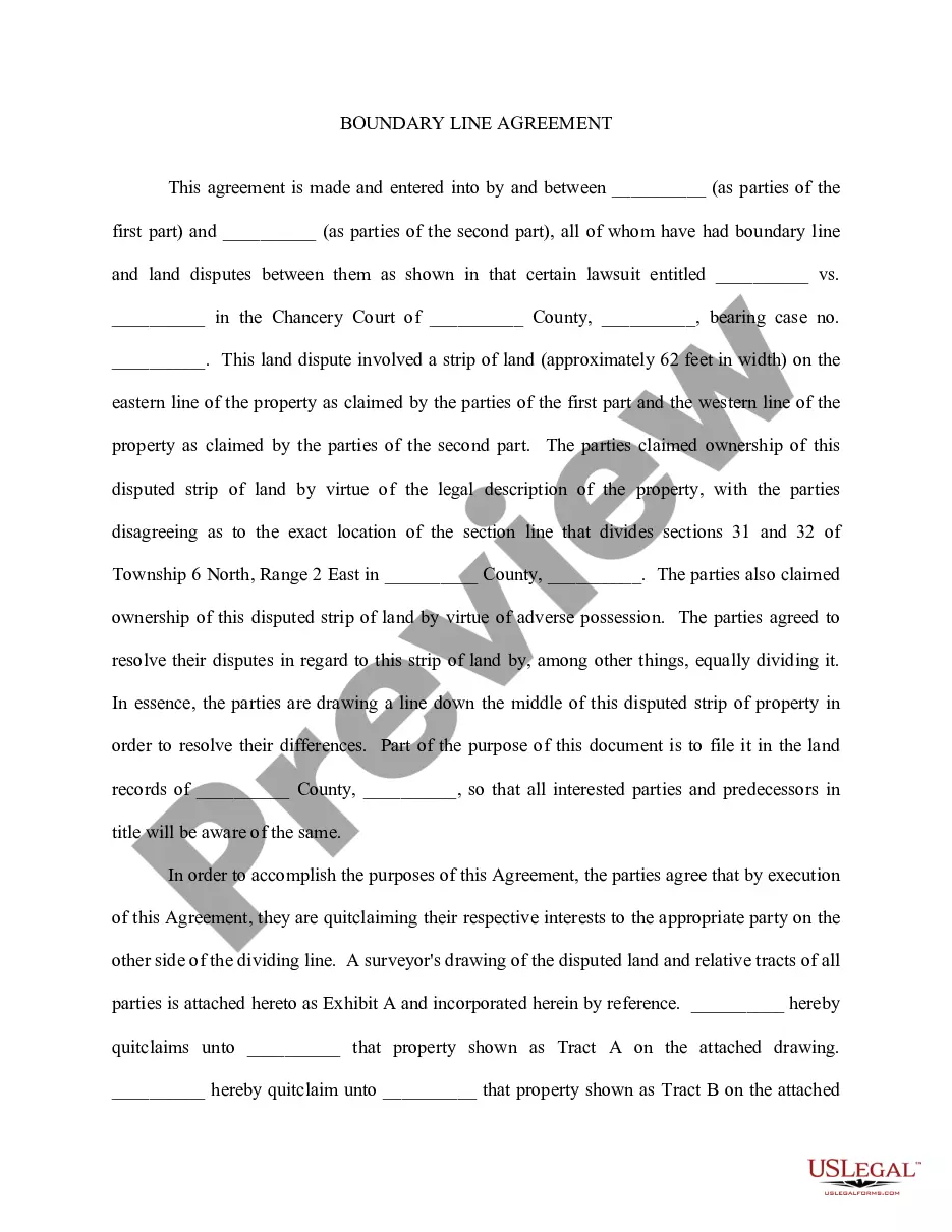
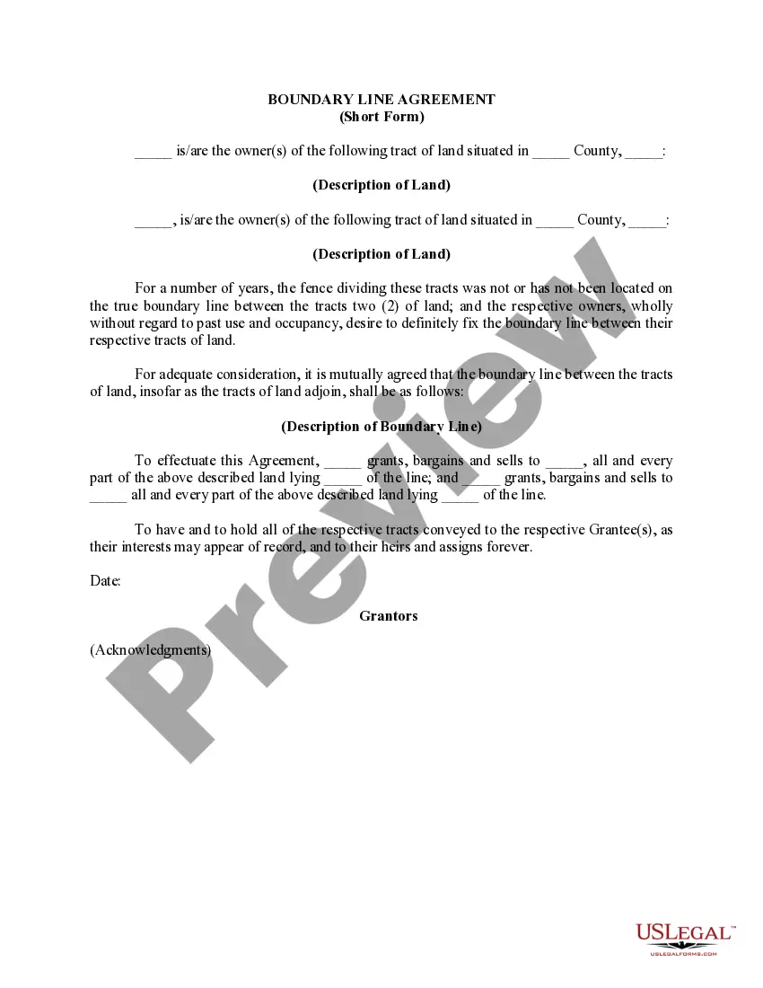
A boundary agreement is an understanding between parties indicating where the boundary between two or more properties exists. The line agreed upon may or may not be the true or original boundary, and it does not have legal value until both parties sign a lot line agreement.
Maritime boundary treaties are treaties that establish a specified ocean or sea boundary between two or more countries or territories. These are also called maritime boundary agreements, maritime delimitation treaties, or maritime delimitation agreements.
A property line, or boundary line, defines the legal limits of your lot. It sets a boundary on who is the rightful owner of a particular plot and helps determine if a neighbor has a right of way to reach their land.
The agreement is between neighboring states or jurisdictions in the United States that set specific boundaries between their properties and serve to resolve territorial disputes. These agreements are useful in resolving boundary disputes, clarifying property lines, and avoiding potential conflicts.