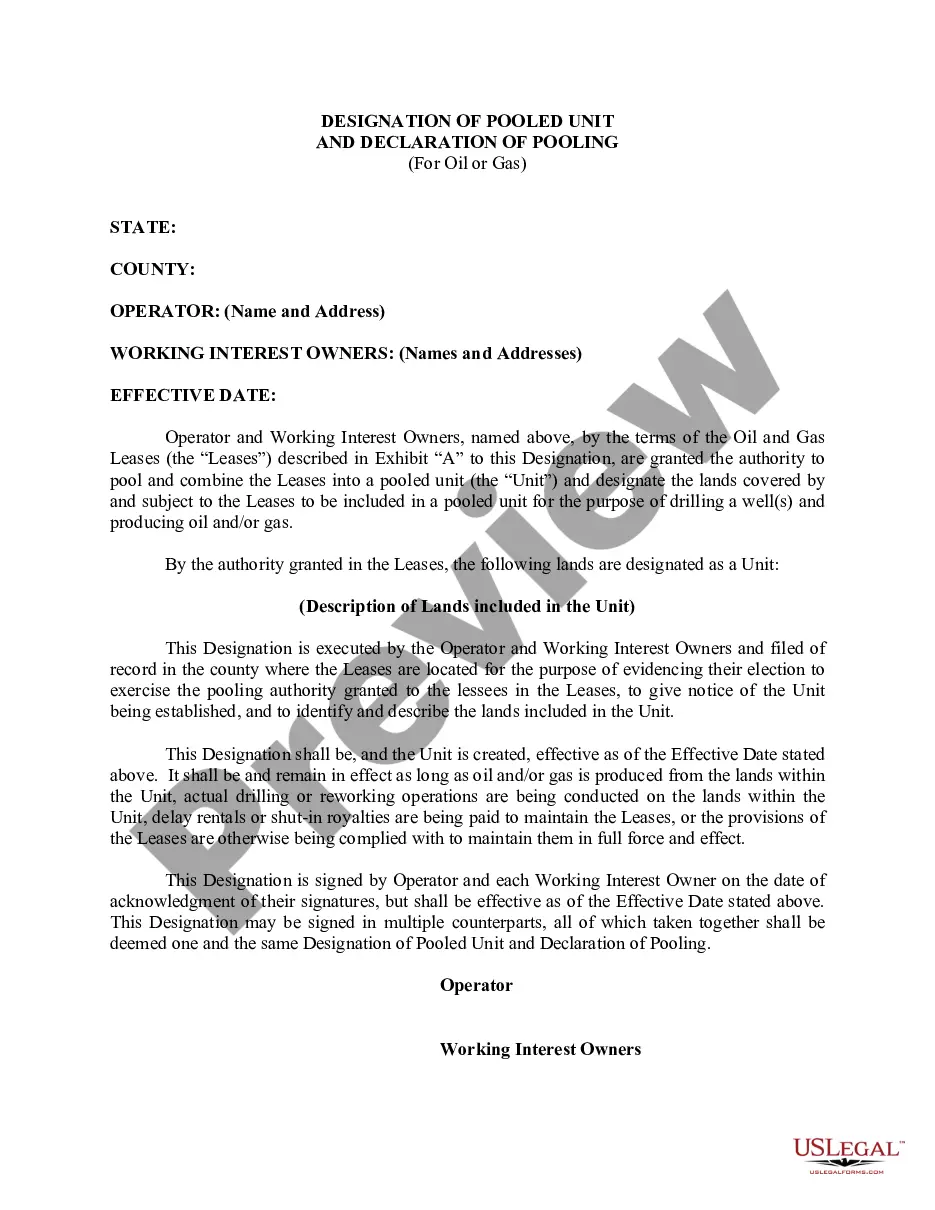
Kentucky Designation of Unit
Description


Get your form ready online
Our built-in tools help you complete, sign, share, and store your documents in one place.
Make edits, fill in missing information, and update formatting in US Legal Forms—just like you would in MS Word.
Download a copy, print it, send it by email, or mail it via USPS—whatever works best for your next step.
Sign and collect signatures with our SignNow integration. Send to multiple recipients, set reminders, and more. Go Premium to unlock E-Sign.
If this form requires notarization, complete it online through a secure video call—no need to meet a notary in person or wait for an appointment.
We protect your documents and personal data by following strict security and privacy standards.

Make edits, fill in missing information, and update formatting in US Legal Forms—just like you would in MS Word.

Download a copy, print it, send it by email, or mail it via USPS—whatever works best for your next step.

Sign and collect signatures with our SignNow integration. Send to multiple recipients, set reminders, and more. Go Premium to unlock E-Sign.

If this form requires notarization, complete it online through a secure video call—no need to meet a notary in person or wait for an appointment.

We protect your documents and personal data by following strict security and privacy standards.
Looking for another form?


How to fill out Designation Of Unit?
US Legal Forms - one of many largest libraries of authorized forms in the States - offers an array of authorized document web templates you can obtain or print. While using internet site, you can get thousands of forms for business and person functions, sorted by types, suggests, or search phrases.You can find the most up-to-date types of forms such as the Kentucky Designation of Unit in seconds.
If you currently have a membership, log in and obtain Kentucky Designation of Unit from the US Legal Forms library. The Download button can look on each and every develop you perspective. You get access to all in the past downloaded forms in the My Forms tab of your bank account.
If you would like use US Legal Forms the very first time, listed below are simple recommendations to get you started off:
- Be sure to have picked the best develop for your area/county. Click the Review button to review the form`s content. See the develop outline to actually have chosen the proper develop.
- In case the develop doesn`t fit your requirements, use the Look for area near the top of the display to find the one which does.
- When you are pleased with the form, validate your decision by visiting the Purchase now button. Then, opt for the pricing strategy you favor and give your qualifications to sign up for an bank account.
- Approach the transaction. Make use of charge card or PayPal bank account to perform the transaction.
- Choose the file format and obtain the form on your product.
- Make adjustments. Fill up, edit and print and indicator the downloaded Kentucky Designation of Unit.
Every template you put into your money does not have an expiry date which is yours eternally. So, in order to obtain or print one more backup, just check out the My Forms area and click on the develop you want.
Obtain access to the Kentucky Designation of Unit with US Legal Forms, the most comprehensive library of authorized document web templates. Use thousands of expert and status-distinct web templates that meet up with your company or person needs and requirements.
Form popularity
FAQ
Building Code Considerations: Decks, as well as porches, attached to the home require building permits as they become part of the main structure. Standalone decks larger than 200 square feet require a building permit.
You need a building permit for all construction that involves the construction, repair, movement to another site, removal, or demolition of any building or structure. All electrical, plumbing and mechanical work needs a separate permit for each trade.
A building permit is required if any owner or authorized agent plans to: Construct, enlarge, remodel or change the occupancy of a building. Erect, , enlarge, alter, repair, remove, or convert a building.
The Department of Housing, Buildings and Construction administers the permitting and licensing for HVAC, plumbing, boilers, electrical, elevators, manufactured housing, and sprinkler systems.
The KBC is a min/max code, meaning that it is a statewide uniform mandatory building code and no local government shall adopt or enforce any other building code; except that the Kentucky Residential Code shall govern detached single family dwellings, two-family dwellings and townhouses.
Yes. Most likely you will need a building permit for your shed. However, if your shed is less than 120 sq. feet (i.e. smaller than 10×20), you are not required by law to obtain a permit in most cases.