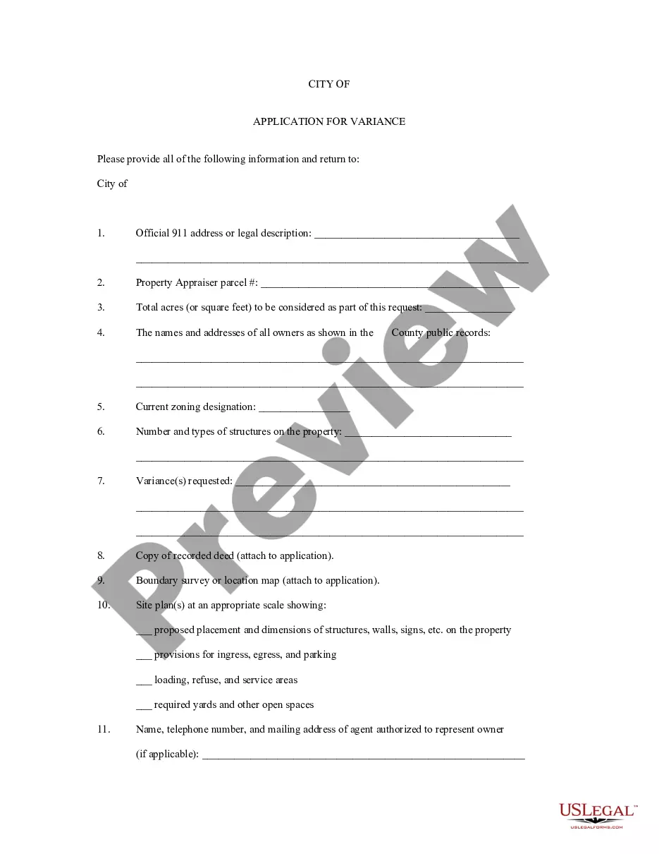
District of Columbia Application for Rezoning and / or Future Land Use Map Amendment
Description


Get your form ready online
Our built-in tools help you complete, sign, share, and store your documents in one place.
Make edits, fill in missing information, and update formatting in US Legal Forms—just like you would in MS Word.
Download a copy, print it, send it by email, or mail it via USPS—whatever works best for your next step.
Sign and collect signatures with our SignNow integration. Send to multiple recipients, set reminders, and more. Go Premium to unlock E-Sign.
If this form requires notarization, complete it online through a secure video call—no need to meet a notary in person or wait for an appointment.
We protect your documents and personal data by following strict security and privacy standards.

Make edits, fill in missing information, and update formatting in US Legal Forms—just like you would in MS Word.

Download a copy, print it, send it by email, or mail it via USPS—whatever works best for your next step.

Sign and collect signatures with our SignNow integration. Send to multiple recipients, set reminders, and more. Go Premium to unlock E-Sign.

If this form requires notarization, complete it online through a secure video call—no need to meet a notary in person or wait for an appointment.

We protect your documents and personal data by following strict security and privacy standards.
Looking for another form?


How to fill out Application For Rezoning And / Or Future Land Use Map Amendment?
If you wish to total, down load, or produce lawful file layouts, use US Legal Forms, the largest collection of lawful kinds, that can be found on the web. Make use of the site`s easy and practical lookup to find the documents you require. Different layouts for enterprise and specific uses are categorized by types and suggests, or keywords and phrases. Use US Legal Forms to find the District of Columbia Application for Rezoning and / or Future Land Use Map Amendment in a number of clicks.
When you are presently a US Legal Forms buyer, log in for your bank account and click on the Acquire option to find the District of Columbia Application for Rezoning and / or Future Land Use Map Amendment. You may also access kinds you previously downloaded inside the My Forms tab of your bank account.
If you are using US Legal Forms initially, follow the instructions beneath:
- Step 1. Make sure you have chosen the form for that right town/land.
- Step 2. Use the Preview solution to check out the form`s content material. Never overlook to read the outline.
- Step 3. When you are not happy using the form, use the Look for area at the top of the screen to find other models in the lawful form template.
- Step 4. Once you have located the form you require, click the Buy now option. Opt for the rates plan you like and include your qualifications to sign up to have an bank account.
- Step 5. Process the transaction. You can utilize your bank card or PayPal bank account to perform the transaction.
- Step 6. Pick the file format in the lawful form and down load it on the product.
- Step 7. Complete, modify and produce or sign the District of Columbia Application for Rezoning and / or Future Land Use Map Amendment.
Every lawful file template you acquire is yours permanently. You may have acces to every single form you downloaded within your acccount. Go through the My Forms section and pick a form to produce or down load once more.
Be competitive and down load, and produce the District of Columbia Application for Rezoning and / or Future Land Use Map Amendment with US Legal Forms. There are many skilled and express-specific kinds you may use for your personal enterprise or specific requires.
Form popularity
FAQ
The purpose of the RF-1 zone is to provide for areas predominantly developed with row houses on small lots within which no more than two (2) dwelling units are permitted. In the RF-1 Zone, 2 dwelling units may be located within the principal structure or 1 each in the principal structure and an accessory structure. Residential Flat (RF) Zones - Zoning Handbook - DC.gov dc.gov ? pages ? residential-flat-rf... dc.gov ? pages ? residential-flat-rf...
A unique set of rules and uses defined for land parcel(s) that are unavailable in other land use districts. Parcels that have unique characteristics, unusual site conditions or innovative design might require special regulations. What is a Direct Control (DC) district? - Heritage Inspires YYC Heritage Inspires YYC ? faqconc ? what-... Heritage Inspires YYC ? faqconc ? what-...
Zoning ordinances and maps classify land into ?Districts? (e.g., Rural Lands, Commercial), ing to the land use designations in the adopted Comprehensive Plan. Each zoning district contains requirements and standards that govern the use and development of land within that district. Zoning Information - Benton County WA benton.wa.us ? pview benton.wa.us ? pview
Zoning in DC is broken down into five major categories: Residential; Mixed Use; Downtown; Production, Distribution, and Repair; and Special Purpose zones.
The R-2 zone is intended to provide for areas predominantly developed with semi-detached houses on moderately sized lots that also contain some detached dwellings. Residential (R) Zones - Zoning Handbook - DC.gov DC.gov ? pages ? residential-r-z... DC.gov ? pages ? residential-r-z...
A Direct Control (DC) is a customized land use designation. It has a list of allowable uses and a set of rules specific to a particular property or development.