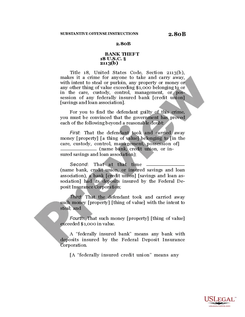
This lease rider form may be used when you are involved in a lease transaction, and have made the decision to utilize the form of Oil and Gas Lease presented to you by the Lessee, and you want to include additional provisions to that Lease form to address specific concerns you may have, or place limitations on the rights granted the Lessee in the “standard” lease form.
Washington Geophysical and Seismic Operations
Category:
State:
Multi-State
Control #:
US-OG-800
Format:
Word;
Rich Text
Instant download
Description
Free preview


Get your form ready online
Our built-in tools help you complete, sign, share, and store your documents in one place.
Built-in online Word editor
Make edits, fill in missing information, and update formatting in US Legal Forms—just like you would in MS Word.
Export easily
Download a copy, print it, send it by email, or mail it via USPS—whatever works best for your next step.
E-sign your document
Sign and collect signatures with our SignNow integration. Send to multiple recipients, set reminders, and more. Go Premium to unlock E-Sign.
Notarize online 24/7
If this form requires notarization, complete it online through a secure video call—no need to meet a notary in person or wait for an appointment.
Store your document securely
We protect your documents and personal data by following strict security and privacy standards.

Make edits, fill in missing information, and update formatting in US Legal Forms—just like you would in MS Word.

Download a copy, print it, send it by email, or mail it via USPS—whatever works best for your next step.

Sign and collect signatures with our SignNow integration. Send to multiple recipients, set reminders, and more. Go Premium to unlock E-Sign.

If this form requires notarization, complete it online through a secure video call—no need to meet a notary in person or wait for an appointment.

We protect your documents and personal data by following strict security and privacy standards.
Looking for another form?

How to fill out Geophysical And Seismic Operations?
US Legal Forms - among the biggest libraries of legal types in America - provides a variety of legal record templates you may obtain or printing. Making use of the internet site, you may get a huge number of types for enterprise and personal uses, sorted by categories, suggests, or keywords.You can get the most recent models of types much like the Washington Geophysical and Seismic Operations within minutes.
If you already have a monthly subscription, log in and obtain Washington Geophysical and Seismic Operations from the US Legal Forms collection. The Down load key will show up on every single form you see. You gain access to all in the past saved types from the My Forms tab of your account.
If you want to use US Legal Forms for the first time, listed here are easy guidelines to get you started:
- Ensure you have chosen the correct form for your personal metropolis/county. Go through the Preview key to examine the form`s content material. See the form description to ensure that you have selected the proper form.
- In case the form does not fit your specifications, make use of the Look for field at the top of the screen to find the the one that does.
- When you are pleased with the form, validate your option by clicking the Acquire now key. Then, opt for the costs program you prefer and offer your credentials to register on an account.
- Approach the financial transaction. Make use of your charge card or PayPal account to perform the financial transaction.
- Pick the file format and obtain the form in your device.
- Make changes. Fill up, change and printing and indication the saved Washington Geophysical and Seismic Operations.
Each and every web template you included in your money lacks an expiration time and is yours permanently. So, if you would like obtain or printing one more duplicate, just check out the My Forms portion and click about the form you want.
Gain access to the Washington Geophysical and Seismic Operations with US Legal Forms, probably the most substantial collection of legal record templates. Use a huge number of professional and state-particular templates that satisfy your company or personal demands and specifications.
Form popularity
FAQ
Seismic energy propagates through media as waves and, under certain conditions, undergoes critical refraction. A critically refracted seismic wave travels along acoustic interfaces and generates new waves that can be detected at the surface.
A hammer plate is a metal plate on which a sledgehammer is struck to generate seismic waves to conduct seismic refraction surveys. Seismic refraction is one of the methods of geophysics used to investigate subsurface ground conditions for trenchless operations. It utilizes seismic waves sourced from the ground surface.
The general principle of seismic reflection is to send elastic waves (using an energy source such as dynamite explosion or Vibroseis) into the Earth, where each layer within the Earth reflects a portion of the wave's energy back and allows the rest to refract through.
The refraction technique uses a long array of geophones to sense refracted waves, and the reflection technique uses a condensed array near the source to sense reflected waves (Fig. 4.10). Reflection surveys are widely used to map the upper crust for oil and gas exploration.
A seismic reflection event to be generated needs necessarily two things, an impedance contrast at the interface of two rock types and a minimum width (Fresnel Zone ) of the interface. The reflection amplitude and its continuity depend on the degree of contrast across the interface and its extent and nature.
Reflection Seismology entails the use of generated parcels of elastic strain energy in rocks measuring the travel time through the rock body from a given seismic source to receivers. This parcels of energy travel as P-and S-waves propagated by compressional-dilational uniaxial strain and pure shear strain respectively.
2.1. The general principle involves sending artificially generated acoustic waves down the water column and into the seafloor, where the different structures and objects within the Earth's crust reflect this energy back ing to their acoustic impedance.
Seismic reflection surveying is the most widely used geophysical technique to explore for hydrocarbons. The measurement of the Earth's gravity and magnetic fields are also used to determine the geometry and depth of particular subsurface areas, known as sedimentary basins, where oil and gas are typically located.