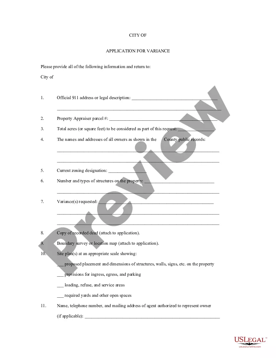
Washington Application for Rezoning and / or Future Land Use Map Amendment
Description


How to fill out Application For Rezoning And / Or Future Land Use Map Amendment?
US Legal Forms - among the largest libraries of legitimate types in the States - offers a variety of legitimate record themes it is possible to down load or produce. Using the web site, you will get thousands of types for organization and specific functions, sorted by categories, states, or keywords and phrases.You will discover the latest models of types just like the Washington Application for Rezoning and / or Future Land Use Map Amendment within minutes.
If you already have a registration, log in and down load Washington Application for Rezoning and / or Future Land Use Map Amendment from your US Legal Forms catalogue. The Acquire key can look on each type you perspective. You have accessibility to all formerly saved types within the My Forms tab of your own bank account.
If you would like use US Legal Forms the very first time, allow me to share basic directions to help you get started off:
- Ensure you have chosen the best type to your area/state. Click the Review key to check the form`s information. Read the type explanation to actually have chosen the proper type.
- If the type doesn`t match your specifications, use the Look for discipline on top of the monitor to obtain the one which does.
- When you are pleased with the shape, verify your choice by visiting the Get now key. Then, select the prices program you favor and provide your accreditations to register for the bank account.
- Procedure the financial transaction. Utilize your Visa or Mastercard or PayPal bank account to finish the financial transaction.
- Choose the file format and down load the shape on the device.
- Make alterations. Complete, modify and produce and indicator the saved Washington Application for Rezoning and / or Future Land Use Map Amendment.
Every design you put into your bank account does not have an expiration day and is the one you have for a long time. So, in order to down load or produce an additional version, just check out the My Forms segment and click on in the type you want.
Obtain access to the Washington Application for Rezoning and / or Future Land Use Map Amendment with US Legal Forms, probably the most considerable catalogue of legitimate record themes. Use thousands of expert and status-specific themes that fulfill your company or specific requirements and specifications.
Form popularity
FAQ
5 or C zones/LCF designation: lands zoned 5 or C by the GPP qualify for an CS with residential density at 1 lot per 200,000 sq. ft. and a minimum density bonus of 15% when a minimum of 45% of the site is contained in restricted open space. ural Cluster Subdivisions Snohomish County snohomishcountywa.gov ? DocumentCenter ? View snohomishcountywa.gov ? DocumentCenter ? View
Enter your 14-digit property tax account number at the "Find Parcel ID" field. Click on go after you have entered your account number. You will be able to view the current zoning designation and comprehensive plan designation. FAQs ? Snohomish County, WA ? CivicEngage Snohomish County, WA (.gov) ? Faq Snohomish County, WA (.gov) ? Faq
Future Land Use Map: A Definition The future land use map is a community's visual guide to future planning. The future land use map should bring together most if not all of the elements of the comprehensive plan such as natural resources, economic development, housing and transportation. 7Chapter Preparing a Future Land Use Map uwsp.edu ? clue ? Comprehensive_Planning uwsp.edu ? clue ? Comprehensive_Planning
425-388-3311 General zoning questions, permitting and land development information can be requested electronically via AskPermitTech. You can also call our switchboard at 425-388-3311 and we'll direct you to someone who can answer your questions. Planning & Development Services | Snohomish County, WA Snohomish County, WA (.gov) ? Planning-Developm... Snohomish County, WA (.gov) ? Planning-Developm...
All buildings must be at least 20 feet from any other lot in a residential, multiple-family, or rural zone. The hearing examiner may require an additional setback distance when necessary to maintain compatibility of the proposed building with residential uses on adjoining properties. 30.23.110 Special setbacks for certain uses | Snohomish County Code county.codes ? SCC county.codes ? SCC
? The professional fee of a town planner can vary between R 24 000 and R 70 000 (and in some cases even more) to assist with a rezoning application in South Africa, depending on several factors. Rezoning in South Africa - Town Planner townplanner.co.za ? services ? rezoning townplanner.co.za ? services ? rezoning
Rezones can be initiated by property owners, the Department of Planning and Development Services (PDS), the County Council,and the Planning Commission. Property owners have two avenues to initiate a rezone request ? either as a Type 2 land use application (quasi-judicial) rezone or a legislative rezone. Rezone | Snohomish County, WA - Official Website Snohomish County, WA (.gov) ? Rezone Snohomish County, WA (.gov) ? Rezone
A Rezone or P-suffix revision application must be filed in person at the Permitting Service Center. An appointment with Permitting staff is required to file the application. Please call 206-296-6797 to schedule an appointment and asked to speak to a Rezone Application Planner. Rezone Application Instructions & Information - King County King County (.gov) ? dper ? lc-ins-rezone-pdf King County (.gov) ? dper ? lc-ins-rezone-pdf PDF