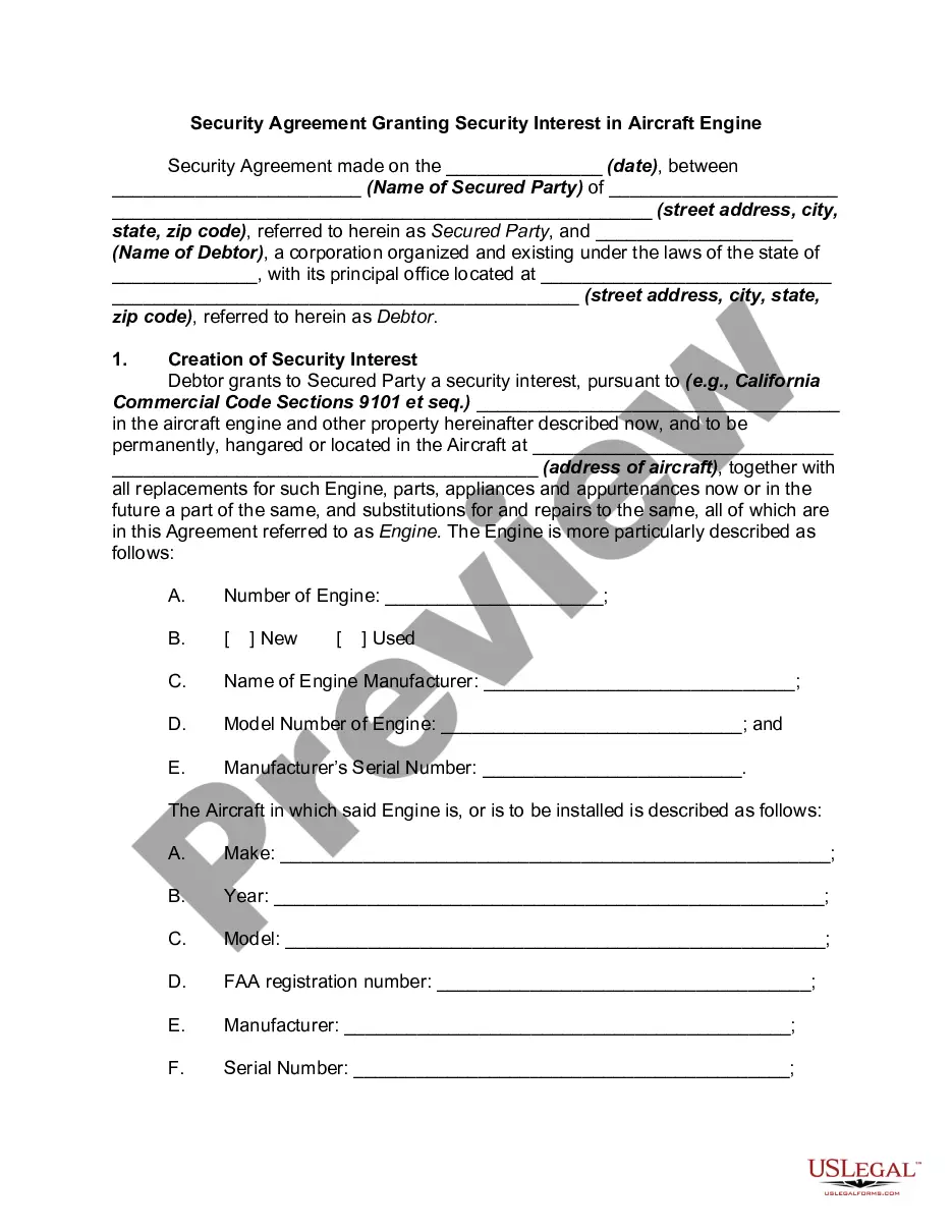
This lease rider form may be used when you are involved in a lease transaction, and have made the decision to utilize the form of Oil and Gas Lease presented to you by the Lessee, and you want to include additional provisions to that Lease form to address specific concerns you may have, or place limitations on the rights granted the Lessee in the “standard” lease form.
South Carolina Geophysical and Seismic Operations
Category:
State:
Multi-State
Control #:
US-OG-800
Format:
Word;
Rich Text
Instant download
Description
Free preview


Get your form ready online
Our built-in tools help you complete, sign, share, and store your documents in one place.
Built-in online Word editor
Make edits, fill in missing information, and update formatting in US Legal Forms—just like you would in MS Word.
Export easily
Download a copy, print it, send it by email, or mail it via USPS—whatever works best for your next step.
E-sign your document
Sign and collect signatures with our SignNow integration. Send to multiple recipients, set reminders, and more. Go Premium to unlock E-Sign.
Notarize online 24/7
If this form requires notarization, complete it online through a secure video call—no need to meet a notary in person or wait for an appointment.
Store your document securely
We protect your documents and personal data by following strict security and privacy standards.

Make edits, fill in missing information, and update formatting in US Legal Forms—just like you would in MS Word.

Download a copy, print it, send it by email, or mail it via USPS—whatever works best for your next step.

Sign and collect signatures with our SignNow integration. Send to multiple recipients, set reminders, and more. Go Premium to unlock E-Sign.

If this form requires notarization, complete it online through a secure video call—no need to meet a notary in person or wait for an appointment.

We protect your documents and personal data by following strict security and privacy standards.
Looking for another form?


How to fill out Geophysical And Seismic Operations?
US Legal Forms - one of the greatest libraries of lawful forms in the USA - provides a variety of lawful papers templates you may acquire or produce. Using the site, you can get thousands of forms for business and personal reasons, categorized by classes, suggests, or keywords.You will discover the latest versions of forms such as the South Carolina Geophysical and Seismic Operations within minutes.
If you have a subscription, log in and acquire South Carolina Geophysical and Seismic Operations through the US Legal Forms catalogue. The Acquire option will appear on each and every develop you view. You have access to all previously saved forms from the My Forms tab of your respective bank account.
In order to use US Legal Forms the first time, listed below are straightforward recommendations to help you started off:
- Be sure you have selected the right develop for your metropolis/region. Go through the Review option to examine the form`s content. See the develop explanation to ensure that you have chosen the correct develop.
- If the develop doesn`t suit your needs, use the Search discipline on top of the display screen to obtain the the one that does.
- In case you are pleased with the form, affirm your selection by clicking the Get now option. Then, opt for the costs plan you prefer and provide your references to register to have an bank account.
- Approach the financial transaction. Make use of your bank card or PayPal bank account to complete the financial transaction.
- Find the format and acquire the form on your system.
- Make changes. Fill up, edit and produce and indicator the saved South Carolina Geophysical and Seismic Operations.
Each web template you put into your bank account does not have an expiry particular date and is also yours eternally. So, in order to acquire or produce yet another copy, just visit the My Forms area and click about the develop you want.
Gain access to the South Carolina Geophysical and Seismic Operations with US Legal Forms, probably the most comprehensive catalogue of lawful papers templates. Use thousands of specialist and express-particular templates that meet your organization or personal requires and needs.
Form popularity
FAQ
South Carolina's quakes are located within a plate rather than at a plate boundary. Perhaps the intraplate quakes felt in South Carolina are the result of stresses transmitted inward from the boundaries of the North American plate.
That's also where South Carolina's most powerful earthquakes were recorded on June 29, 2022. On that day, two earthquakes ? one a 3.5 magnitude and the other 3.6 ? were included in a flurry of tremors and aftershocks. Those were the two largest quakes to hit South Carolina in nearly a decade.
The two most significant historical earthquakes to occur in South Carolina were the 1886 Charleston/Summerville earthquake and the 1913 Union County earthquake. The 1886 earthquake in Charleston was the most damaging earthquake to ever occur in the eastern United States.
Prehistoric earthquakes of similar size to the 1886 shock have occurred in coastal South Carolina at intervals of several centuries to several thousands of years. In recent decades, damaging earthquakes much smaller than that of 1886 have occurred every decade or two, most recently in 2014 (magnitude 4.1).
Tuesday's earthquake happened at about 7 miles beneath the surface, ing to the USGS. It was the eighth confirmed quake in South Carolina in 2023, ing to the state Department of Natural Resources.
Fault zones In South Carolina, approximately 70 percent of the earthquakes occur in the Coastal Plain and most are clustered around three areas west and north of Charleston: Ravenel-Adams Run-Hollywood, Middleton Place-Summerville, and Bowman.
The largest in state history was a 7.3-magnitude quake that hit the Charleston area in 1886, killing at least 60 people, leveling buildings in a city still recovering from the Civil War, and causing $158 million in damage in inflation-adjusted figures.