Michigan Seismic Data and Operations

State:
Multi-State
Control #:
US-OG-720
Format:
Word; 
Rich Text
Instant download

Description

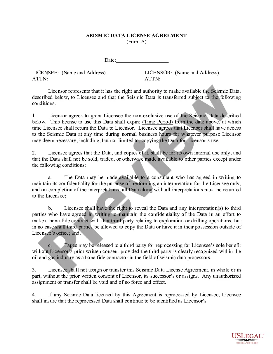
This form is used when the Parties agree and shall contribute all proprietary seismic data and all non-proprietary seismic data affecting the Contract Area in its possession as of the effective date of this Agreement, to the extent the data is not restricted by confidentiality or licensing agreements with third parties. It is specifically understood and agreed that each Party has the right to sell, trade, and/or otherwise market seismic data involving the Contract Area which was in its possession prior to the effective date of this Agreement, and the benefits and advantages, including monetary consideration, which it receives as a result of those activities shall be the sole property of the party who owns the data.

How to fill out Seismic Data And Operations?

If you have to full, obtain, or produce lawful file themes, use US Legal Forms, the most important selection of lawful types, that can be found online. Make use of the site`s easy and hassle-free research to find the documents you require. Various themes for organization and person functions are sorted by categories and says, or key phrases. Use US Legal Forms to find the Michigan Seismic Data and Operations with a handful of clicks.

In case you are previously a US Legal Forms client, log in for your profile and click on the Download option to have the Michigan Seismic Data and Operations. You can even accessibility types you in the past saved in the My Forms tab of your own profile.

If you work with US Legal Forms the very first time, follow the instructions beneath:

  • Step 1. Make sure you have selected the form for that correct city/land.
  • Step 2. Use the Preview choice to look over the form`s information. Do not neglect to read through the explanation.
  • Step 3. In case you are not happy using the form, utilize the Search area at the top of the monitor to discover other types of the lawful form format.
  • Step 4. After you have discovered the form you require, click on the Buy now option. Pick the prices strategy you prefer and add your accreditations to register for an profile.
  • Step 5. Approach the deal. You can use your charge card or PayPal profile to perform the deal.
  • Step 6. Find the file format of the lawful form and obtain it on your device.
  • Step 7. Total, modify and produce or indicator the Michigan Seismic Data and Operations.

Each lawful file format you acquire is your own permanently. You may have acces to each and every form you saved inside your acccount. Select the My Forms segment and decide on a form to produce or obtain once more.

Contend and obtain, and produce the Michigan Seismic Data and Operations with US Legal Forms. There are millions of specialist and condition-certain types you can utilize for your organization or person needs.

Form popularity

FAQ

The purpose of acquiring and processing seismic data is to learn something about the Earth's interior. To understand certain aspects of the Earth, we initially need to figure out some specific relations between the intended targets and measurable parameters.

Seismometers at seven stations record ground movement, and the data collected can be analyzed to determine the direction, intensity, duration, depth, epicenter, and magnitude of an earthquake. The data also provide insight into whether and how rocks in the subsurface moved after an earthquake.

As such, seismic surveys can be effective at mapping geologic layers/structure and determining the types of subsurface materials. In typical active-source seismic surveys, a seismic source (e.g., sledgehammer) is used to transmit seismic energy into the subsurface.

7) How much does it cost to collect seismic data? The cost of acquisition depends on permit costs, crew costs, and other equipment costs. Currently, it costs around $75,000 per square mile to acquire 3D seismic data.

Ing to a seismic probability map prepared by the U.S. Coast and Geodetic Survey, Michigan lies in a region of low risk for earthquake occurrence.

Michigan doesn't normally have earthquakes. However, we can suffer effects from earthquakes in neighboring states that have a higher likelihood of them.

Seismic surveys use reflected sound waves to produce a ?CAT scan? of the Earth's subsurface. Seismic surveys can help locate ground water, are used to investigate locations for landfills, and characterize how an area will shake during an earthquake, but they are primarily used for oil and gas exploration.

Seismic data provide structural and static information for a reservoir such as lateral extent of the reservoir, thickness, faults, porosity, among other reservoir properties. Time-lapse seismic acquired at different times measures changes in reservoir state.

Trusted and secure by over 3 million people of the world’s leading companies

Michigan Seismic Data and Operations