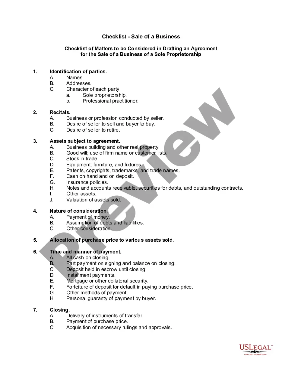
This lease rider form may be used when you are involved in a lease transaction, and have made the decision to utilize the form of Oil and Gas Lease presented to you by the Lessee, and you want to include additional provisions to that Lease form to address specific concerns you may have, or place limitations on the rights granted the Lessee in the “standard” lease form.
Michigan Geophysical and Seismic Operations
Category:
State:
Multi-State
Control #:
US-OG-800
Format:
Word;
Rich Text
Instant download
Description
Free preview


Get your form ready online
Our built-in tools help you complete, sign, share, and store your documents in one place.
Built-in online Word editor
Make edits, fill in missing information, and update formatting in US Legal Forms—just like you would in MS Word.
Export easily
Download a copy, print it, send it by email, or mail it via USPS—whatever works best for your next step.
E-sign your document
Sign and collect signatures with our SignNow integration. Send to multiple recipients, set reminders, and more. Go Premium to unlock E-Sign.
Notarize online 24/7
If this form requires notarization, complete it online through a secure video call—no need to meet a notary in person or wait for an appointment.
Store your document securely
We protect your documents and personal data by following strict security and privacy standards.

Make edits, fill in missing information, and update formatting in US Legal Forms—just like you would in MS Word.

Download a copy, print it, send it by email, or mail it via USPS—whatever works best for your next step.

Sign and collect signatures with our SignNow integration. Send to multiple recipients, set reminders, and more. Go Premium to unlock E-Sign.

If this form requires notarization, complete it online through a secure video call—no need to meet a notary in person or wait for an appointment.

We protect your documents and personal data by following strict security and privacy standards.
Looking for another form?


How to fill out Geophysical And Seismic Operations?
Are you presently in the placement the place you need documents for sometimes organization or specific purposes virtually every day? There are plenty of legal record templates available on the Internet, but getting kinds you can rely on isn`t simple. US Legal Forms gives 1000s of kind templates, such as the Michigan Geophysical and Seismic Operations, that are created to fulfill federal and state needs.
If you are presently informed about US Legal Forms web site and have a free account, basically log in. Afterward, it is possible to download the Michigan Geophysical and Seismic Operations format.
If you do not come with an profile and want to begin using US Legal Forms, abide by these steps:
- Discover the kind you require and ensure it is to the correct metropolis/region.
- Use the Review switch to analyze the form.
- See the outline to actually have chosen the proper kind.
- When the kind isn`t what you`re trying to find, make use of the Research discipline to discover the kind that meets your needs and needs.
- Whenever you find the correct kind, just click Purchase now.
- Select the prices prepare you want, complete the specified information to create your account, and pay for the transaction making use of your PayPal or Visa or Mastercard.
- Select a hassle-free paper structure and download your backup.
Discover all of the record templates you have bought in the My Forms menus. You may get a more backup of Michigan Geophysical and Seismic Operations any time, if needed. Just click on the necessary kind to download or print the record format.
Use US Legal Forms, probably the most substantial variety of legal types, to conserve some time and steer clear of mistakes. The service gives skillfully manufactured legal record templates which can be used for an array of purposes. Generate a free account on US Legal Forms and begin creating your way of life easier.
Form popularity
FAQ
Seismic surveys use reflected sound waves to produce a ?CAT scan? of the Earth's subsurface. Seismic surveys can help locate ground water, are used to investigate locations for landfills, and characterize how an area will shake during an earthquake, but they are primarily used for oil and gas exploration.
Seismic methods are increasingly used by this industry for a wide range of commodities including base metals, uranium, diamonds, and precious metals. Seismic methods provide high-resolution images of geologic structures hosting mineral deposits and, in a few cases, can be used for direct targeting of mineral deposits.
REMOTE SENSING APPROACHES | Geophysical Seismic or acoustic methods measure the travel times of the reflected or refracted waves detected by a series of geophones placed on the ground surface and are able to estimate the location and depth of the targets.
Seismic data is the principal geophysical method used to image the subsurface in both land and marine environments.
A hammer plate is a metal plate on which a sledgehammer is struck to generate seismic waves to conduct seismic refraction surveys. Seismic refraction is one of the methods of geophysics used to investigate subsurface ground conditions for trenchless operations. It utilizes seismic waves sourced from the ground surface.
The seismic survey is one form of geophysical survey that aims at measuring the earth's (geo-) properties by means of physical (-physics) principles such as magnetic, electric, gravitational, thermal, and elastic theories.
Seismic methods are techniques based on the measurement and study of the propagation of seismic waves. Precisely, seismic methods measure the elastic properties of soils and rocks that are a function of the physical properties such as seismic velocity, density, and shear modulus.
Geophysical methods provide both quantitative and qualitative information. Properties such as electrical resistance, seismic reflection/refraction, or magnetism can be used to interpret geologic characteristics such as porosity, permeability, water content of the formation, and/or mineralogy.