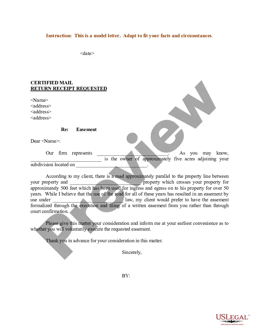
Kentucky Sample Letter regarding Survey Maps
Description
Get your form ready online
Our built-in tools help you complete, sign, share, and store your documents in one place.
Make edits, fill in missing information, and update formatting in US Legal Forms—just like you would in MS Word.
Download a copy, print it, send it by email, or mail it via USPS—whatever works best for your next step.
Sign and collect signatures with our SignNow integration. Send to multiple recipients, set reminders, and more. Go Premium to unlock E-Sign.
If this form requires notarization, complete it online through a secure video call—no need to meet a notary in person or wait for an appointment.
We protect your documents and personal data by following strict security and privacy standards.

Make edits, fill in missing information, and update formatting in US Legal Forms—just like you would in MS Word.

Download a copy, print it, send it by email, or mail it via USPS—whatever works best for your next step.

Sign and collect signatures with our SignNow integration. Send to multiple recipients, set reminders, and more. Go Premium to unlock E-Sign.

If this form requires notarization, complete it online through a secure video call—no need to meet a notary in person or wait for an appointment.

We protect your documents and personal data by following strict security and privacy standards.
Looking for another form?

How to fill out Sample Letter Regarding Survey Maps?
US Legal Forms - among the biggest libraries of lawful varieties in America - provides an array of lawful file layouts it is possible to obtain or print. Making use of the internet site, you may get a huge number of varieties for company and individual purposes, sorted by groups, says, or key phrases.You will discover the most recent types of varieties such as the Kentucky Sample Letter regarding Survey Maps within minutes.
If you already have a registration, log in and obtain Kentucky Sample Letter regarding Survey Maps in the US Legal Forms catalogue. The Down load option will show up on every develop you perspective. You have accessibility to all in the past delivered electronically varieties inside the My Forms tab of your account.
If you wish to use US Legal Forms for the first time, listed here are straightforward instructions to obtain started:
- Be sure you have picked out the best develop for the metropolis/state. Click on the Preview option to check the form`s articles. Browse the develop information to ensure that you have chosen the proper develop.
- If the develop doesn`t fit your specifications, utilize the Look for discipline on top of the screen to get the one who does.
- If you are pleased with the shape, verify your decision by clicking the Acquire now option. Then, select the rates plan you prefer and supply your qualifications to sign up for the account.
- Process the purchase. Use your bank card or PayPal account to accomplish the purchase.
- Find the format and obtain the shape on your own device.
- Make adjustments. Complete, edit and print and indicator the delivered electronically Kentucky Sample Letter regarding Survey Maps.
Each and every design you put into your account does not have an expiration particular date and is the one you have forever. So, in order to obtain or print an additional version, just check out the My Forms portion and click on about the develop you require.
Gain access to the Kentucky Sample Letter regarding Survey Maps with US Legal Forms, probably the most considerable catalogue of lawful file layouts. Use a huge number of specialist and express-distinct layouts that satisfy your company or individual requires and specifications.
Form popularity
FAQ
Common Surveyor Symbols Surveyor flags (sometimes referred to as streamers) and tape are attached to trees, fences, or a stake placed by the survey. ... Similar to surveyor flags, a control point is a place on the property that the surveyor does not want to be disturbed.
Research Time Research TimeCost RangeRegular survey$380?$750Research-intensive survey$1,380?$1,750
How Much Does a House Survey Cost in 2023? Survey TypeAverage Surveyor FeeRICS Valuation£320RICS Level 1 Survey£380RICS Level 2 Survey£500RICS Level 3 Survey£800
A land survey costs $200 to $1,200 on average or $70 to $140 per acre for large land plots. An ALTA or ACSM survey costs $1,200 to $4,000 for a platted lot less than 10,000 sq.
Radius (R) The distance from the center point of a curve to the arc of a curve. Arc (A) Arc length. The distance along a curve.
Generally, you can expect a land survey in North Carolina to cost under $1,000. That said, larger lots with more unique features are going to be more expensive to assess. The more survey specifications you request, too, the more our professionals may charge.
A survey stake is typically small, with a pointed end to make it easy to drive into the earth. It may be color-coded or have a space for people to write information on the stake. Surveyors use stakes when assessing sites to mark out boundaries, record data, and convey information to other people.
An average land survey costs $200 to $1,200. A boundary survey costs $500 to $1,000 for one acre with prices of $70 to $140 per acre for sites from 50 to 100 acres. The cost of a property survey depends on the type, plot dimensions, and complexity of past records. Get free estimates from land surveyors near you.