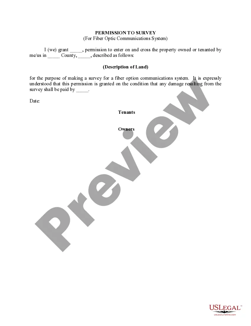
Indiana Permission to Survey (Pipeline Right of Way)
Description


How to fill out Permission To Survey (Pipeline Right Of Way)?
You are able to devote several hours on-line looking for the legitimate record template that fits the state and federal demands you need. US Legal Forms provides a huge number of legitimate kinds which can be analyzed by specialists. It is possible to download or printing the Indiana Permission to Survey (Pipeline Right of Way) from my support.
If you have a US Legal Forms account, it is possible to log in and then click the Download option. After that, it is possible to total, edit, printing, or indication the Indiana Permission to Survey (Pipeline Right of Way). Each and every legitimate record template you purchase is your own property forever. To get another duplicate of the acquired type, proceed to the My Forms tab and then click the related option.
If you work with the US Legal Forms website for the first time, stick to the easy recommendations listed below:
- Initial, ensure that you have chosen the correct record template for the area/town that you pick. Browse the type explanation to ensure you have picked the proper type. If accessible, utilize the Review option to check with the record template also.
- In order to find another version of the type, utilize the Research area to get the template that meets your needs and demands.
- After you have found the template you desire, simply click Purchase now to continue.
- Pick the pricing strategy you desire, type your qualifications, and sign up for a free account on US Legal Forms.
- Total the transaction. You can use your bank card or PayPal account to purchase the legitimate type.
- Pick the formatting of the record and download it for your product.
- Make alterations for your record if necessary. You are able to total, edit and indication and printing Indiana Permission to Survey (Pipeline Right of Way).
Download and printing a huge number of record layouts making use of the US Legal Forms Internet site, that offers the biggest assortment of legitimate kinds. Use specialist and condition-certain layouts to handle your business or specific needs.
Form popularity
FAQ
During the pipeline right-of-way surveying process, it's important that you gather detailed information about the proposed route quickly. This can be accomplished using a modern land surveying technology such as unmanned aerial vehicles (UAVs).
Under Indiana law, easements may be created by grant, prescription, or implication. An easement by grant is the most common. Such easement arises by way of a deed or contract, and the scope of easement holder's rights are controlled by the governing terms of the instrument.
(a) The minimum right-of-way width for all public and private roads, except fire or emergency roads, shall be sixty (60) feet.
Sec. 15.5. (a) As used in this section, "apparent right-of-way" means the location and width of county highway right-of-way for purposes of use and control of the right-of-way by the county executive. (b) A county executive may establish the apparent right-of-way of a county highway.
Anytime a person or business does any construction work in the road right-of-way (normally 40 feet wide - 20 feet on either side of the center of the road) they need to obtain a permit.
Pedestrians and cyclists usually have the right-of-way when sharing the road. Drivers maneuvering at an intersection must yield to those in the crosswalk. This means a driver making a right, left or U-turn must wait for the crosswalk at an intersection to be clear before making the turn.
What you need to know. A pipeline right-of-way (ROW) is a strip of land of varying widths that may contain one or more pipelines. To deliver critically needed natural gas via our network, Enbridge must at times cross private and public lands.
")