Guam Letter of Intent Acquisition of 3-D Data
Description


How to fill out Letter Of Intent Acquisition Of 3-D Data?
If you wish to comprehensive, obtain, or produce authorized file themes, use US Legal Forms, the largest collection of authorized forms, which can be found on the Internet. Take advantage of the site`s simple and easy hassle-free lookup to obtain the paperwork you want. Various themes for company and specific uses are sorted by types and claims, or keywords and phrases. Use US Legal Forms to obtain the Guam Letter of Intent Acquisition of 3-D Data in just a handful of mouse clicks.
When you are presently a US Legal Forms buyer, log in to your account and then click the Obtain switch to find the Guam Letter of Intent Acquisition of 3-D Data. You may also access forms you in the past downloaded within the My Forms tab of your respective account.
If you are using US Legal Forms the first time, refer to the instructions listed below:
- Step 1. Be sure you have chosen the shape for the proper town/nation.
- Step 2. Use the Review method to look through the form`s information. Don`t forget about to read the description.
- Step 3. When you are unhappy together with the kind, use the Search field at the top of the display screen to locate other types of the authorized kind template.
- Step 4. After you have identified the shape you want, go through the Buy now switch. Opt for the costs strategy you choose and add your references to sign up to have an account.
- Step 5. Procedure the financial transaction. You may use your credit card or PayPal account to accomplish the financial transaction.
- Step 6. Find the file format of the authorized kind and obtain it in your system.
- Step 7. Total, modify and produce or sign the Guam Letter of Intent Acquisition of 3-D Data.
Every authorized file template you buy is your own eternally. You may have acces to every kind you downloaded within your acccount. Click the My Forms area and decide on a kind to produce or obtain again.
Compete and obtain, and produce the Guam Letter of Intent Acquisition of 3-D Data with US Legal Forms. There are millions of skilled and condition-particular forms you may use for your company or specific demands.
Form popularity
FAQ
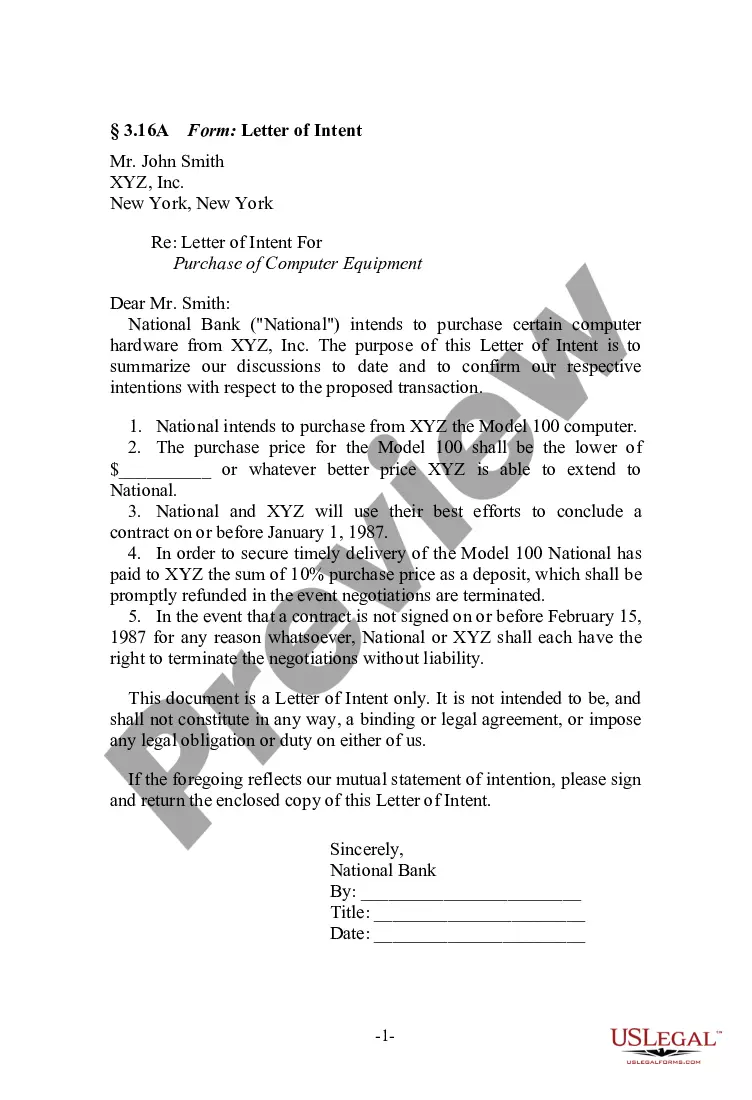
The key terms of an LOI are the following: Purchase price and terms. Assets and liabilities included, especially working capital. Form of consideration, such as cash, stock, earnout, or notes. Legal transaction structure (asset sale or stock sale) Seller's ongoing role and compensation.
It is common for a letter of intent in a merger or acquisition to include the following sections: Purchased Assets. Assumed Liabilities. Purchase Price. Pre-Closing Covenants. Conditions To Obligations. Due Diligence. Confidentiality. Non Competition.
Components of a LOI Opening Paragraph: Your summary statement. ... Statement of Need: The "why" of the project. ( ... Project Activity: The "what" and "how" of the project. ( ... Outcomes (1?2 paragraphs; before or after the Project Activity) ... Credentials (1?2 paragraphs) ... Budget (1?2 paragraphs) ... Closing (1 paragraph) ... Signature.
Besides detailing the price and payment terms of the transaction, the LOI includes items such as description of the assets to be purchased, any assumed liabilities, the terms of the seller's non-compete agreement, the timeline for due diligence and closing, a confidentiality provision, and an exclusivity provision, ...
What is a letter of intent? A letter of intent (LOI) is a document written in business letter format that declares your intent to do a specific thing. It's usually, but not always, nonbinding, and it states a preliminary commitment by one party to do business with another party.
Components of a LOI Opening Paragraph: Your summary statement. ... Statement of Need: The "why" of the project. ( ... Project Activity: The "what" and "how" of the project. ( ... Outcomes (1?2 paragraphs; before or after the Project Activity) ... Credentials (1?2 paragraphs) ... Budget (1?2 paragraphs) ... Closing (1 paragraph) ... Signature.
Typically, the LOI will include purchase price and terms, the assets and liabilities included in the deal, exclusivity, and the conditions required to close the transaction. If accepted by the sell-side, the LOI is immediately followed by the due diligence phase of the transaction.