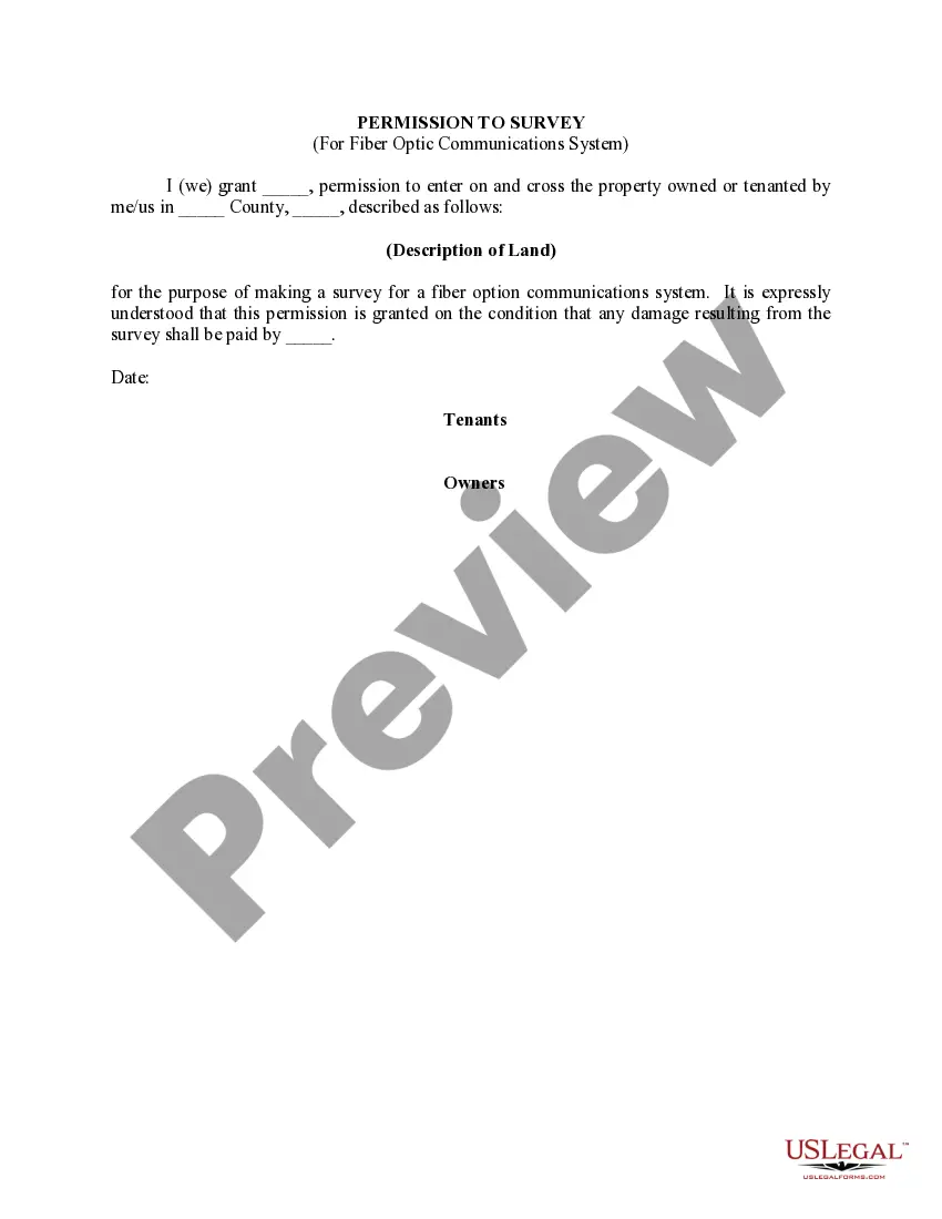
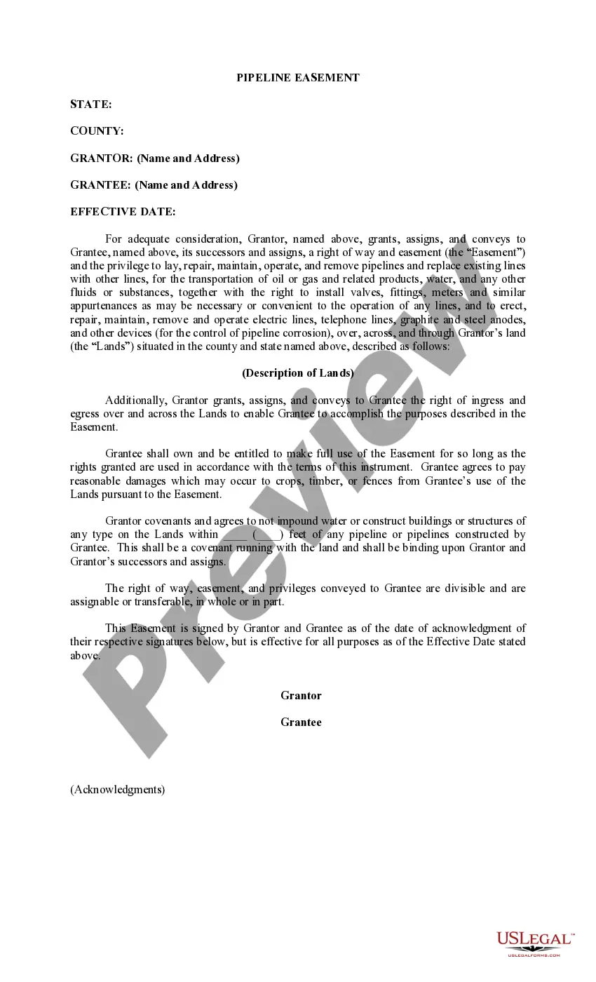
Delaware Permission to Survey (Pipeline Right of Way)
Description
How to fill out Permission To Survey (Pipeline Right Of Way)?
If you want to full, download, or produce legal file templates, use US Legal Forms, the largest assortment of legal kinds, which can be found online. Use the site`s basic and practical search to obtain the paperwork you require. Numerous templates for organization and person functions are categorized by types and claims, or keywords. Use US Legal Forms to obtain the Delaware Permission to Survey (Pipeline Right of Way) within a number of click throughs.
Should you be already a US Legal Forms customer, log in to the profile and click on the Download key to find the Delaware Permission to Survey (Pipeline Right of Way). Also you can gain access to kinds you earlier saved within the My Forms tab of the profile.
If you use US Legal Forms initially, follow the instructions beneath:
- Step 1. Ensure you have chosen the form for the proper town/land.
- Step 2. Make use of the Review solution to check out the form`s information. Don`t forget about to see the explanation.
- Step 3. Should you be unhappy with all the kind, use the Search discipline on top of the monitor to discover other types in the legal kind web template.
- Step 4. Once you have found the form you require, click on the Acquire now key. Pick the prices plan you like and include your credentials to register on an profile.
- Step 5. Approach the transaction. You can utilize your bank card or PayPal profile to accomplish the transaction.
- Step 6. Find the formatting in the legal kind and download it on your own gadget.
- Step 7. Complete, modify and produce or sign the Delaware Permission to Survey (Pipeline Right of Way).
Every legal file web template you acquire is your own property eternally. You may have acces to each and every kind you saved with your acccount. Click the My Forms area and choose a kind to produce or download once more.
Remain competitive and download, and produce the Delaware Permission to Survey (Pipeline Right of Way) with US Legal Forms. There are millions of specialist and condition-certain kinds you can use for your organization or person needs.
Form popularity
FAQ
Pipelines can pollute air, water, soil and climate when they leak. Pipelines that cross rivers and streams are more vulnerable to breaks when heavy rain and floods occur.
What you need to know. A pipeline right-of-way (ROW) is a strip of land of varying widths that may contain one or more pipelines. To deliver critically needed natural gas via our network, Enbridge must at times cross private and public lands.
Most normal agricultural activities are permitted on the pipeline right-of-way, but some activities still require written consent to ensure the safety of everyone involved, either due to the depth of the activity, or the weight of the equipment involved.
Pipeline surveys are an umbrella term for any land survey completed in service to the placing or maintenance of a pipeline. New pipelines can use land survey data to decide the most efficient route, while existing pipelines are often surveyed when checking for or confirming damage. Pipeline Surveys and Pipeline Integrity Surveys - McClure mcclurevision.com ? services ? survey ? pipeline-... mcclurevision.com ? services ? survey ? pipeline-...
Above-ground pipeline markers are used along the permanent right-of-way for easy recognition of the presence of underground pipelines. The markers are typically located in a ?line of sight? manner within the rights-of-way, along streets and at road and railroad crossings. Understanding The Right of Way - Nexus Gas Transmission nexusgastransmission.com ? understanding_... nexusgastransmission.com ? understanding_...
Natural gas pipelines do not affect the property value of any particular type of residence any more or less than another type of residence. Pipeline Impact to Property Value and Property Insurability - INGAA ingaa.org ? pipeline-impact-to-property-value-and... ingaa.org ? pipeline-impact-to-property-value-and...
Pipeline stocks can be great income investments That gives them the funds to pay attractive dividends and invest in expanding their operations. Because of that, pipeline stocks tend to be great options for investors seeking to generate some passive income.
Natural gas pipelines do not affect the property value of any particular type of residence any more or less than another type of residence. The sales frequency of homes ?on? the pipeline is consistent with those ?off? the pipeline, indicating that the presence of a pipeline does not inhibit sales.
The chances of a pipeline leak or explosion on your property is relatively small, but the consequences can be huge.
A pipeline right-of-way (ROW) is a strip of land of varying widths that may contain one or more pipelines. To deliver critically needed natural gas via our network, Enbridge must at times cross private and public lands. Pipeline rights-of-way: What you need to know enbridge.com ? Enb ? Documents ? Factsheets enbridge.com ? Enb ? Documents ? Factsheets
")