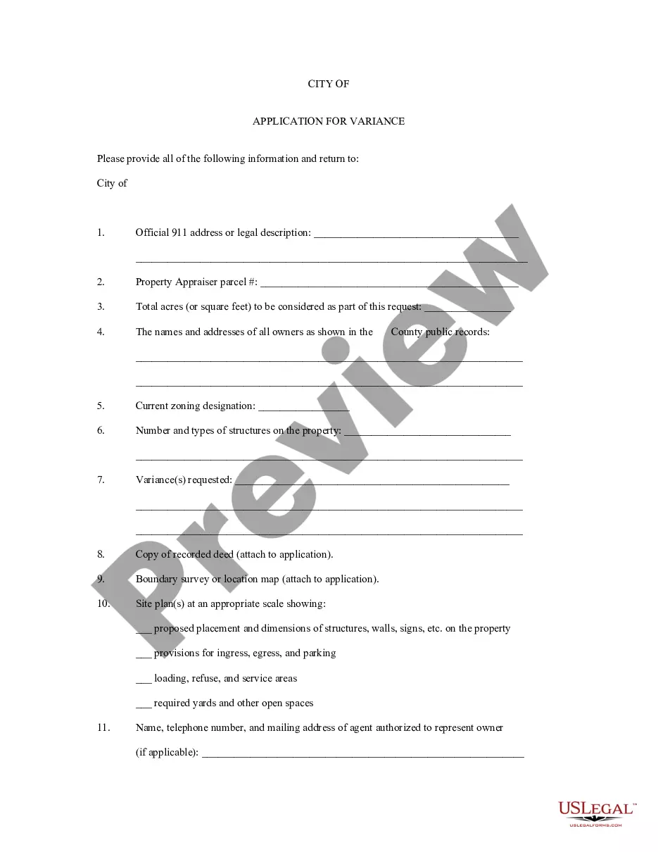
Tennessee Application for Rezoning and / or Future Land Use Map Amendment
Description


Get your form ready online
Our built-in tools help you complete, sign, share, and store your documents in one place.
Make edits, fill in missing information, and update formatting in US Legal Forms—just like you would in MS Word.
Download a copy, print it, send it by email, or mail it via USPS—whatever works best for your next step.
Sign and collect signatures with our SignNow integration. Send to multiple recipients, set reminders, and more. Go Premium to unlock E-Sign.
If this form requires notarization, complete it online through a secure video call—no need to meet a notary in person or wait for an appointment.
We protect your documents and personal data by following strict security and privacy standards.
Looking for another form?
How to fill out Application For Rezoning And / Or Future Land Use Map Amendment?
US Legal Forms - one of many greatest libraries of lawful types in the States - provides a wide range of lawful papers web templates you are able to acquire or printing. Using the web site, you will get thousands of types for company and person uses, categorized by groups, states, or keywords.You can find the latest versions of types much like the Tennessee Application for Rezoning and / or Future Land Use Map Amendment within minutes.
If you currently have a membership, log in and acquire Tennessee Application for Rezoning and / or Future Land Use Map Amendment through the US Legal Forms catalogue. The Down load switch will show up on every single develop you see. You get access to all earlier delivered electronically types in the My Forms tab of your account.
If you want to use US Legal Forms the very first time, allow me to share straightforward instructions to help you started out:
- Be sure you have selected the best develop for the city/county. Click on the Preview switch to check the form`s content. See the develop outline to actually have selected the right develop.
- If the develop doesn`t fit your demands, utilize the Look for area near the top of the monitor to discover the one that does.
- Should you be happy with the shape, confirm your choice by clicking the Buy now switch. Then, choose the rates plan you want and give your references to sign up for the account.
- Approach the deal. Make use of your credit card or PayPal account to complete the deal.
- Select the format and acquire the shape on your own system.
- Make alterations. Fill up, revise and printing and indicator the delivered electronically Tennessee Application for Rezoning and / or Future Land Use Map Amendment.
Every single web template you put into your money lacks an expiry date and is the one you have forever. So, if you want to acquire or printing another backup, just proceed to the My Forms portion and then click on the develop you want.
Gain access to the Tennessee Application for Rezoning and / or Future Land Use Map Amendment with US Legal Forms, by far the most substantial catalogue of lawful papers web templates. Use thousands of specialist and condition-particular web templates that satisfy your small business or person requirements and demands.
Form popularity
FAQ
R30 and R20 Districts. Intended for low to moderate intensity one-family and two-family development, these districts are appropriate for implementing the residential low-medium density policies of the general plan.
601. A-1 General Agriculture District. It is the intent of this district to provide space for agriculture and agriculturally oriented uses and structures which provide an important part in the economy of Washington County, and at the same time provide space for residential development for an ever expanding population.
Zone Change Process Step 1- Application. ... Step 2 - Staff Review. ... Step 3 ? Public Notices. ... Step 4 - Recommendation to the Planning Commission. ... Step 5 - Planning Commission recommendation to Metro Council. ... Step 6 - Metropolitan Council Action. ... Step 7 - Mayor signs the Bill.
R8, R8-A* (medium density residential, requiring a minimum 8,000 square foot lot and intended for single and two-family dwellings) R6, R6-A* (medium density residential, requiring a minimum 6,000 square foot lot and intended for single and two-family dwellings)
T.C.A. §§ 13-3-401 and 13-4-301 define a subdivision as: Dividing any tract or parcel into two or more lots, site, or other divisions requiring new street or utility construction; or. Any division less than five acres for sale of building development.
604. R-1 Low Density Residential District. This is the most restricted residential district, intended for low density single-family use along with open areas which appear likely to develop in a similar manner.