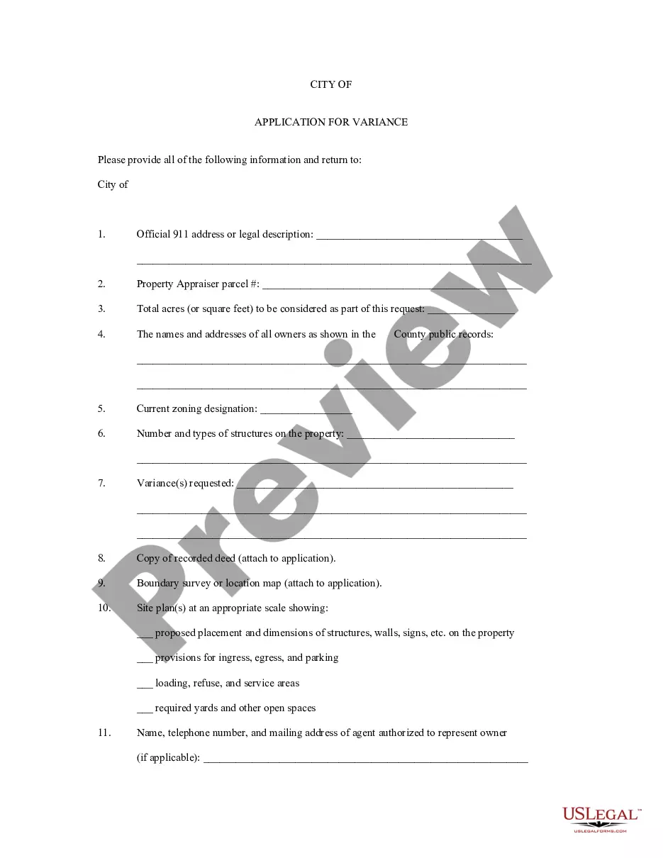
Oklahoma Application for Rezoning and / or Future Land Use Map Amendment
Description


How to fill out Application For Rezoning And / Or Future Land Use Map Amendment?
You are able to invest several hours on the Internet attempting to find the authorized record web template that suits the state and federal needs you require. US Legal Forms provides 1000s of authorized forms which can be reviewed by specialists. You can easily obtain or produce the Oklahoma Application for Rezoning and / or Future Land Use Map Amendment from my assistance.
If you currently have a US Legal Forms profile, you can log in and then click the Down load option. After that, you can comprehensive, modify, produce, or signal the Oklahoma Application for Rezoning and / or Future Land Use Map Amendment. Every single authorized record web template you acquire is your own property forever. To have another version for any obtained kind, go to the My Forms tab and then click the related option.
If you are using the US Legal Forms site initially, keep to the easy directions below:
- First, make sure that you have selected the correct record web template for your area/city of your choice. Browse the kind explanation to ensure you have chosen the right kind. If available, use the Preview option to check from the record web template also.
- If you would like locate another model in the kind, use the Look for discipline to obtain the web template that suits you and needs.
- When you have located the web template you need, click on Acquire now to move forward.
- Choose the rates prepare you need, type in your accreditations, and sign up for a free account on US Legal Forms.
- Total the financial transaction. You may use your bank card or PayPal profile to cover the authorized kind.
- Choose the file format in the record and obtain it to your device.
- Make adjustments to your record if needed. You are able to comprehensive, modify and signal and produce Oklahoma Application for Rezoning and / or Future Land Use Map Amendment.
Down load and produce 1000s of record themes while using US Legal Forms web site, that provides the largest variety of authorized forms. Use expert and status-specific themes to tackle your business or individual demands.
Form popularity
FAQ
The R-1 District is the most restrictive residential district. The principal use is single-family residential with provisions for related recreational, religious and educational facilities that are normally required to provide the basic elements of a balanced and attractive residential area. ARTICLE VI. - ZONING BASE DISTRICTS | Oklahoma City, OK Municode Library ? code_of_ordinances Municode Library ? code_of_ordinances
The City Council makes all final decisions on rezoning applications. There are two City Council meetings. At the first meeting the item is Introduced and set for final hearing. At the final hearing the Council may approve, approve with conditions, or deny an item.
The minimum residential lot for a single-family dwelling shall be 5,000 square feet with not less than 3,250 square feet per family on any lot. Zoning Definitions okcommerce.gov ? wp-content ? uploads okcommerce.gov ? wp-content ? uploads
The purpose of zoning regulations is to promote the health, safety and welfare of Oklahoma communities. This generally requires boards and commissions to weigh the rights of those seeking rezoning or a particular land use with the rights of nearby property owners. Municipal Planning and Zoning: An Overview of State Statutes and ... okbar.org ? november-2022 ? childs_2 okbar.org ? november-2022 ? childs_2
To request a Rezoning, please fill out a Map Amendment application. The Rezoning process begins when a completed application, survey of area to be rezoned and the required nonrefundable fee are submitted by the appropriate deadline. The Application is then checked for accuracy by the Planning staff. Rezoning, Conditional Zoning, & Special Use Permits | Fayetteville, NC fayettevillenc.gov ? our-city ? rezoning-con... fayettevillenc.gov ? our-city ? rezoning-con...