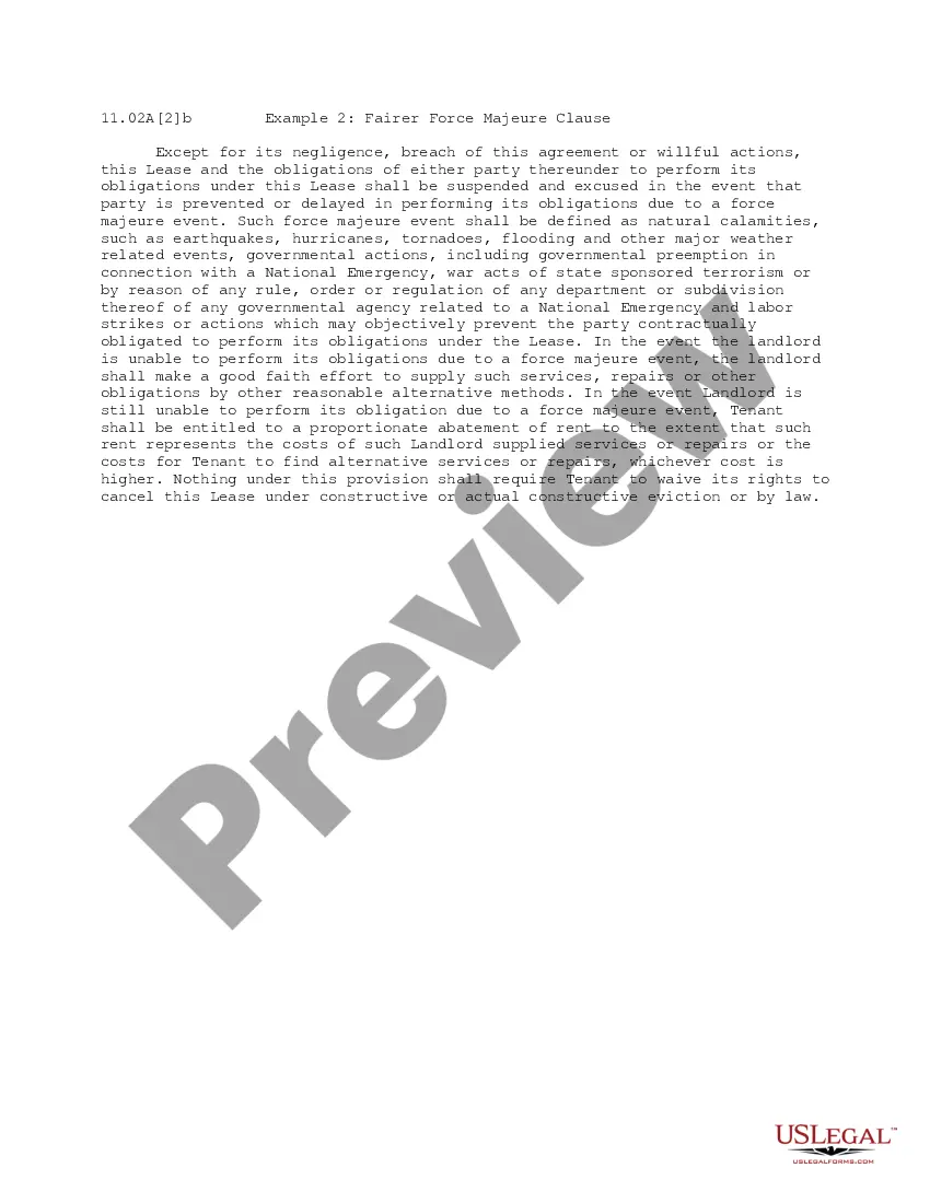
This form provides that any Party may propose that geoscience operations be conducted on the Contract Area lands. The Party wishing to conduct geoscience operations shall furnish the other Parties with an information notice which generally describes the proposed geoscience operation.
New York Geoscience Operations on the Contract Area
Category:
State:
Multi-State
Control #:
US-OG-705
Format:
Word;
Rich Text
Instant download
Description
Free preview


Get your form ready online
Our built-in tools help you complete, sign, share, and store your documents in one place.
Built-in online Word editor
Make edits, fill in missing information, and update formatting in US Legal Forms—just like you would in MS Word.
Export easily
Download a copy, print it, send it by email, or mail it via USPS—whatever works best for your next step.
E-sign your document
Sign and collect signatures with our SignNow integration. Send to multiple recipients, set reminders, and more. Go Premium to unlock E-Sign.
Notarize online 24/7
If this form requires notarization, complete it online through a secure video call—no need to meet a notary in person or wait for an appointment.
Store your document securely
We protect your documents and personal data by following strict security and privacy standards.

Make edits, fill in missing information, and update formatting in US Legal Forms—just like you would in MS Word.

Download a copy, print it, send it by email, or mail it via USPS—whatever works best for your next step.

Sign and collect signatures with our SignNow integration. Send to multiple recipients, set reminders, and more. Go Premium to unlock E-Sign.

If this form requires notarization, complete it online through a secure video call—no need to meet a notary in person or wait for an appointment.

We protect your documents and personal data by following strict security and privacy standards.
Looking for another form?
How to fill out Geoscience Operations On The Contract Area?
If you have to total, obtain, or print out legitimate papers layouts, use US Legal Forms, the most important variety of legitimate forms, which can be found on-line. Take advantage of the site`s simple and convenient lookup to get the paperwork you need. Numerous layouts for business and person uses are sorted by types and suggests, or keywords and phrases. Use US Legal Forms to get the New York Geoscience Operations on the Contract Area with a number of click throughs.
When you are presently a US Legal Forms customer, log in in your account and then click the Acquire switch to have the New York Geoscience Operations on the Contract Area. You may also entry forms you earlier acquired within the My Forms tab of the account.
Should you use US Legal Forms for the first time, follow the instructions beneath:
- Step 1. Be sure you have selected the form for your right area/region.
- Step 2. Use the Review solution to look through the form`s content material. Never overlook to learn the description.
- Step 3. When you are not satisfied using the kind, utilize the Look for area at the top of the monitor to locate other types from the legitimate kind format.
- Step 4. After you have identified the form you need, select the Buy now switch. Choose the rates program you like and include your qualifications to register for the account.
- Step 5. Method the purchase. You may use your charge card or PayPal account to complete the purchase.
- Step 6. Choose the file format from the legitimate kind and obtain it on the device.
- Step 7. Complete, modify and print out or indication the New York Geoscience Operations on the Contract Area.
Each legitimate papers format you buy is your own property eternally. You have acces to every single kind you acquired in your acccount. Click the My Forms area and pick a kind to print out or obtain once more.
Contend and obtain, and print out the New York Geoscience Operations on the Contract Area with US Legal Forms. There are many expert and express-certain forms you can use for your business or person needs.
Form popularity
FAQ
Significant bedrock types and features include Fordham Gneiss (visible at Van Cortlandt Park, especially around Vault Hill north of the Parade Ground and an exposed section overlooking the Harlem River Ship Canal across from Inwood Hill Park, most notable for the giant ?C? painted by Columbia students), the Hartland ...
Several major rock units comprise the stratigraphic section beneath this portion of the city: the Middle Proterozoic Fordham Gneiss, the Cambrian Manhattan Formation, and of the Cambrian and Ordovician Inwood Marble. Outcrops of these formations disclose the complex, northeastward-trending structure of the region.
Central Park is home to innumerable rock outcrops, making it one of the few places in the City with visible evidence of the island's ancient bedrock. Known as Manhattan schist, this bedrock was formed around 500 million years ago and contains other minerals, including quartz, mica, and feldspar.
Manhattan's bedrock is composed primarily of two types of rock: Manhattan Schist and Fordham Gneiss. Manhattan Schist is a type of metamorphic rock that is strong, and durable, making it an ideal building material for many of New York City's famous skyscrapers.
New York City is primarily composed of sediments that were metamorphosed during the Taconic and Acadian orogenies roughly 500 - 400 million years ago. Garnets can be found in the rocks of the Hartland Formation and Manhattan Schist (view a NYC rock sample ).