New York Flood Zone Statement and Authorization
Overview of this form
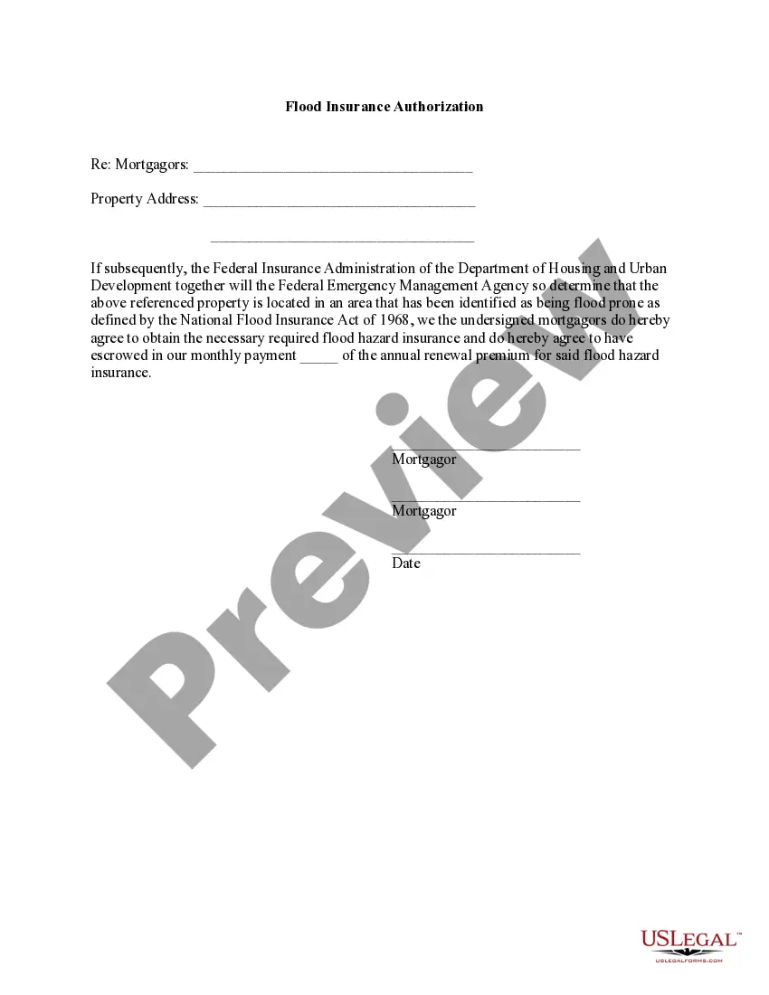
The Flood Zone Statement and Authorization form is a legal document that sellers use to declare the flood zone status of a property. It ensures that buyers are aware of whether the property is in a flood-prone area, as defined by the National Flood Insurance Act of 1968. This form differs from other real estate documents by specifically addressing flood risk and the buyer's obligation to obtain flood insurance if necessary.
Main sections of this form
- Property address field: where the specific property location is entered.
- Sellers' statement section: allows sellers to confirm whether the property is in a flood zone.
- Buyers' acknowledgment: notes that buyers understand the flood zone status and their insurance obligations.
- Signature fields: mandatory signatures from both sellers and buyers, including dates and addresses.


When to use this form
This form is typically used during the sale of residential or commercial properties located in areas that may be subject to flooding. Sellers should provide this statement to buyers to ensure transparency regarding potential flood risks. This is crucial during real estate transactions, especially in flood-prone regions where obtaining flood insurance may be necessary.
Who needs this form
This form is intended for:
- Property sellers who want to disclose the flood zone status of their property.
- Prospective buyers seeking assurance about the flood risk of a property before completing a real estate transaction.
- Real estate agents and brokers facilitating the sale of properties, ensuring compliance with disclosure requirements.
Steps to complete this form
- Identify the property by entering the complete address in the provided field.
- Sellers should check the appropriate box indicating whether the property is located in a flood-prone area.
- If applicable, include information from a flood certification form, if attached.
- Buyers must read and acknowledge the flood status, including their agreement to obtain flood insurance if necessary.
- Both parties must sign the document, dating and providing their addresses where indicated.
Does this form need to be notarized?
Notarization is generally not required for this form. However, certain states or situations might demand it. You can complete notarization online through US Legal Forms, powered by Notarize, using a verified video call available anytime.
Get your form ready online
Our built-in tools help you complete, sign, share, and store your documents in one place.
Make edits, fill in missing information, and update formatting in US Legal Forms—just like you would in MS Word.
Download a copy, print it, send it by email, or mail it via USPS—whatever works best for your next step.
Sign and collect signatures with our SignNow integration. Send to multiple recipients, set reminders, and more. Go Premium to unlock E-Sign.
If this form requires notarization, complete it online through a secure video call—no need to meet a notary in person or wait for an appointment.
We protect your documents and personal data by following strict security and privacy standards.
Make edits, fill in missing information, and update formatting in US Legal Forms—just like you would in MS Word.
Download a copy, print it, send it by email, or mail it via USPS—whatever works best for your next step.
Sign and collect signatures with our SignNow integration. Send to multiple recipients, set reminders, and more. Go Premium to unlock E-Sign.

If this form requires notarization, complete it online through a secure video call—no need to meet a notary in person or wait for an appointment.
We protect your documents and personal data by following strict security and privacy standards.
Avoid these common issues
- Failing to check the appropriate box regarding the flood zone status.
- Ignoring to attach relevant flood certification documents if indicated.
- Not obtaining all necessary signatures from both sellers and buyers.
- Leaving the property address incomplete or incorrect.
Benefits of using this form online
- Convenient access allows users to complete the form at their own pace.
- Editable templates ensure accurate and specific information can be entered.
- Reliable resource drafted by licensed attorneys to ensure legal compliance.
Looking for another form?
Form popularity
FAQ
The City of Manhattan maintains approximately 743 acres of designated open space in the Special Flood Hazard Area (SFHA).
The designation AE indicates areas at high risk for flooding and provides the base flood elevations (BFEs) for them. The AE designation replaced the old designations of A1 to A30, known as the numbered A zones.
Areas that are likely to be flooded are displayed on the map with a blue overlay. It is also possible to right-click on any location and view the elevation level at that point. If you want to share a Flood Map search you can cut and paste a link to the current map view.
The simplest way to find out if a house is in a flood risk area is to visit the government website and enter the postcode of the area in which you are interested. Areas are graded for flood risk, from 'high' to 'very low', usually depending on their proximity to rivers and the previous history of flooding in the area.
Flood Zone A. Areas subject to inundation by the 1-percent-annual-chance flood event generally determined using approximate methodologies. Flood Zone AE, A1-30. Flood Zone AH. Flood Zone AO. Flood Zone AR. Flood Zone A99. Flood Zone V. Flood Zone VE, V1-30.
Simply enter a property's address on the FEMA Flood Map Service Center website, and a map showing its flood zone hazard will pop up. Zones B, X, and C are at the lowest risk, while high-risk zones start with either an A or a V (V zones are coastal areas) on the map.
Roughly 400,000 New Yorkers, 71,500 buildings, and 532 million square feet of floor area are located within the updated 100- year floodplain, also known as the 1 percent annual chance floodplain (because there is a 1 percent or greater chance of flooding in any given year).
A Flood Zone is a geographical area that is rated to reflect the severity or type of flooding in that area.Areas of minimal flood hazard, Zone C or Zone X are areas outside the SFHA and higher than the elevation of the 0.2-percent-annual-chance flood.
How to View and Obtain Flood Maps. The FEMA Flood Map Service Center (MSC) is the official online location to find all flood hazard mapping products created under the NFIP, including your community's flood map.