Colorado Application for Rezoning and / or Future Land Use Map Amendment
Description


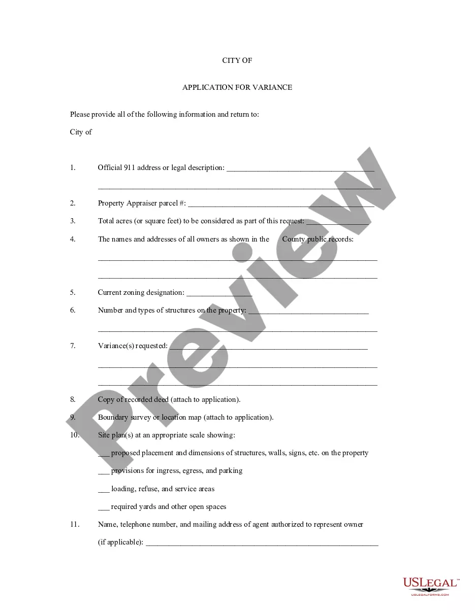

How to fill out Application For Rezoning And / Or Future Land Use Map Amendment?
US Legal Forms - one of the greatest libraries of lawful varieties in the USA - delivers a wide array of lawful record web templates you may download or produce. Making use of the site, you may get thousands of varieties for enterprise and individual purposes, categorized by categories, says, or keywords and phrases.You can get the newest versions of varieties much like the Colorado Application for Rezoning and / or Future Land Use Map Amendment in seconds.
If you already possess a subscription, log in and download Colorado Application for Rezoning and / or Future Land Use Map Amendment from your US Legal Forms catalogue. The Down load key will appear on each form you look at. You get access to all formerly saved varieties in the My Forms tab of your own bank account.
If you wish to use US Legal Forms the very first time, here are easy guidelines to help you get started out:
- Be sure you have picked the best form for your personal city/state. Click on the Preview key to check the form`s content. Browse the form explanation to ensure that you have selected the appropriate form.
- In case the form doesn`t suit your needs, take advantage of the Lookup area near the top of the monitor to obtain the one that does.
- Should you be content with the shape, verify your option by simply clicking the Buy now key. Then, pick the costs strategy you prefer and provide your credentials to sign up for the bank account.
- Approach the purchase. Make use of your charge card or PayPal bank account to perform the purchase.
- Find the structure and download the shape in your product.
- Make alterations. Fill out, revise and produce and sign the saved Colorado Application for Rezoning and / or Future Land Use Map Amendment.
Each and every template you included in your bank account lacks an expiry time and is yours eternally. So, if you would like download or produce another backup, just check out the My Forms portion and click on the form you need.
Get access to the Colorado Application for Rezoning and / or Future Land Use Map Amendment with US Legal Forms, probably the most substantial catalogue of lawful record web templates. Use thousands of specialist and condition-particular web templates that satisfy your small business or individual requirements and needs.
Form popularity
FAQ
Denver Zoning Code. The first element of your zone district represents the neighborhood context. The second part represents the general description, and the third part represents the minimum zone lot size or maximum building height.
This zone is intended to provide the option of developing subdivisions that preserve open space through the reduction of lot size requirements when certain development standards are met.
Email rezoning@denvergov.org or the staff case manager and include the address of the proposed rezoning. Visit the Planning Board page for instructions on when and how to submit written comments or speak at upcoming Planning Board hearings.
The customer submits a complete, signed application in electronic format, a Micro- soft Word document containing the legal description for the area proposed to be rezoned, and the required fee to CPD. Checks should be made payable to ?Manager of Finance? and must be mailed or delivered to CPD.
Rezoning is a public process that changes a property's zone district. From the time an application is submitted, rezoning can take four to six months, depending on the complexity of the case, and involves public hearings before the Planning Board and Denver City Council.