Vancouver Washington Flood Zone Statement and Authorization

State:
Washington
City:
Vancouver
Control #:
WA-CLOSE4
Format:
Word; 
Rich Text
Instant download

Description

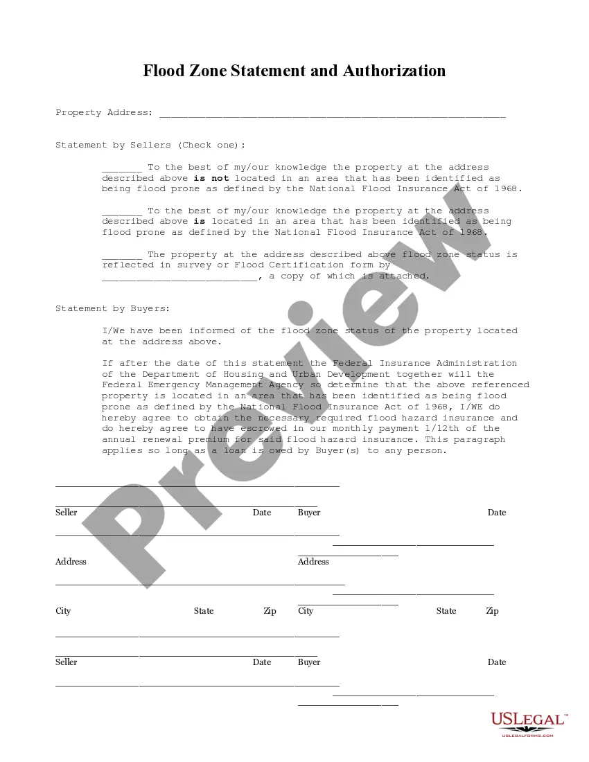
This Flood Zone Statement and Authorization form is for seller(s) to sign, stating the flood zone status of the property and for the buyers to acknowledge the same and state that should the property ever be determined to be in a flood zone, that they will obtain flood insurance.

Vancouver Washington Flood Zone Statement and Authorization is a legal document required by lenders and insurance companies to ascertain if a property is located within a designated flood zone. This statement serves as a crucial part of the loan approval process and insurance coverage determination for properties in the Vancouver, Washington area. The purpose of the Vancouver Washington Flood Zone Statement and Authorization is to determine the level of risk associated with a property, as flood zones vary in severity. By obtaining this statement and authorization, lenders and insurers can make informed decisions regarding flood insurance requirements, loan terms, and conditions. The statement typically includes information such as the property's address, legal description, and details on its proximity to rivers, streams, or other bodies of water. It also provides valuable data sourced from FEMA's Flood Insurance Rate Map (FIRM), which indicates the property's flood zone designation and identifies whether it falls into a high-risk Special Flood Hazard Area (FHA) or a moderate-to-low-risk area. Different types of Vancouver Washington Flood Zone Statement and Authorization may include: 1. Standard Flood Hazard Determination: This involves a verification process to determine whether the property is situated in a flood zone or outside the floodplain boundaries. Different flood zones are classified based on the likelihood and severity of flooding. 2. Elevation Certificate: If a property is determined to be within a flood zone, an elevation certificate may be required. This document provides detailed information on the property's elevation, including the lowest floor level, the location of mechanical systems, and other important details that assist in determining flood insurance premiums. 3. Letter of Map Amendment (COMA): In some cases, an owner or developer may dispute a property's flood zone designation due to updated topographic data or changes in the surrounding area. A COMA is a formal request submitted to FEMA to revise or remove a property from the FHA, based on scientific or technical evidence indicating that the property is situated at or above the base flood elevation. It is vital for property owners and potential buyers in Vancouver, Washington, to understand the implications of being located within a flood zone, as it can significantly impact insurance costs, property values, and even development or renovation plans. Obtaining a Vancouver Washington Flood Zone Statement and Authorization provides important information that assists in making informed decisions regarding flood insurance coverage and overall property management.

How to fill out Vancouver Washington Flood Zone Statement And Authorization?

Irrespective of social or vocational standing, completing law-related documents is an unfortunate requirement in today's professional landscape.

Frequently, it’s nearly impossible for someone without legal education to compose such paperwork from scratch, primarily due to the complicated terminology and legal nuances they encompass.

This is where US Legal Forms can come to the rescue.

Confirm that the form you found is tailored to your locality since the regulations of one state or county do not apply to another.

Review the form and read a brief description (if available) of the situations the document can be utilized for.

  1. Our service presents an extensive repository with over 85,000 ready-to-use state-specific templates that cater to nearly any legal scenario.
  2. US Legal Forms is also a valuable resource for associates or legal advisors looking to conserve time using our DIY documents.
  3. Whether you need the Vancouver Washington Flood Zone Statement and Authorization or any other document that is appropriate in your state or county, with US Legal Forms, everything is readily available.
  4. Here’s how you can acquire the Vancouver Washington Flood Zone Statement and Authorization in minutes by utilizing our reliable service.
  5. If you are already a subscriber, you can go ahead and Log In to your account to download the required document.
  6. However, if you are new to our site, ensure to follow these steps before obtaining the Vancouver Washington Flood Zone Statement and Authorization.

Form popularity

FAQ

The highest flood risk category generally falls under the VE zone, as it signifies areas with not only flooding but also potential wave action. Within the Vancouver Washington Flood Zone Statement and Authorization, being in a VE zone means that property owners must take risk mitigation seriously. Understanding that this category indicates a serious risk helps residents prepare effectively. Awareness and preparation can protect both lives and property.

The best flood zone rating is typically associated with areas marked as X, meaning they are considered low to moderate risk for flooding. In the Vancouver Washington Flood Zone Statement and Authorization, having a good rating can significantly reduce flood insurance premiums. Understanding your rating empowers you to take informed actions for your property. Always check with local authorities to confirm your risk level.

Zone A represents areas that are at risk for flooding but lack detailed flood elevation data. This zone is essential when assessing the potential threat posed to properties in the Vancouver Washington Flood Zone Statement and Authorization. Residents should remain aware and prepared for flood risks, as the absence of data does not mean the absence of risk. Staying informed can mitigate potential losses.

The letters AE indicate a flood zone that is at risk for flooding but typically does not experience wave action like VE zones. In the context of the Vancouver Washington Flood Zone Statement and Authorization, AE zones can still pose significant risks, especially during heavy rains or storms. Homeowners in these areas should consider flood insurance and safeguarding their property. Knowing your zone helps in grasping the necessary steps for protection.

VE stands for 'Violent Waves' and denotes a flood zone at high risk for flooding and wave action. Properties in a VE zone should prepare for potential water surges and related damage. When dealing with the Vancouver Washington Flood Zone Statement and Authorization, understanding this zone is crucial for both safety and insurance coverage. Thus, being aware of this designation can help you take the right precautions.

Global flood frequency data refers to statistical information that estimates the likelihood and recurrence of flooding in different regions worldwide. This data is essential for understanding patterns and guiding local preparations, including the Vancouver Washington Flood Zone Statement and Authorization. Utilizing such data aids governments and communities in making informed decisions regarding flood management.

To stay updated about flooding in your area, you can monitor weather alerts and subscribe to local emergency notifications. Community resources and websites often provide information connected to the Vancouver Washington Flood Zone Statement and Authorization. Additionally, engaging with local flood management authorities can keep you informed about potential hazards.

To access flood data, you can visit the FEMA website, where they offer maps and resources related to flood zones. Local government offices may also provide valuable information regarding the Vancouver Washington Flood Zone Statement and Authorization. Utilizing these resources ensures you stay informed about your area's flood risks.

Identifying flood-prone areas involves consulting flood maps and local resources provided by FEMA and local government agencies. These resources often highlight zones designated by the Vancouver Washington Flood Zone Statement and Authorization. Additionally, utilizing online maps and tools can help you assess risks and prepare for potential flooding.

Several software programs aid in flood planning and management. Popular options include HEC-RAS and FEMA's National Flood Hazard Layer. By utilizing these tools, communities can evaluate flood risks and better understand the implications of the Vancouver Washington Flood Zone Statement and Authorization.

More info

Instructions for completing this form can be found on the following pages. Narrative Statement.In the Fort Vancouver National Historic Site General Management Plan. HUB International is a leading North American insurance brokerage that provides employee benefits, business, and personal insurance products and services. Can I see Public Alerts on Google Maps with my mobile browser? United States. Army. Fellow Gaz staffer John Griffin lasted all of five minutes (and left before I arrived). United States. Congress.

Trusted and secure by over 3 million people of the world’s leading companies

Vancouver Washington Flood Zone Statement and Authorization