Hawaii Application for Rezoning and / or Future Land Use Map Amendment
Description


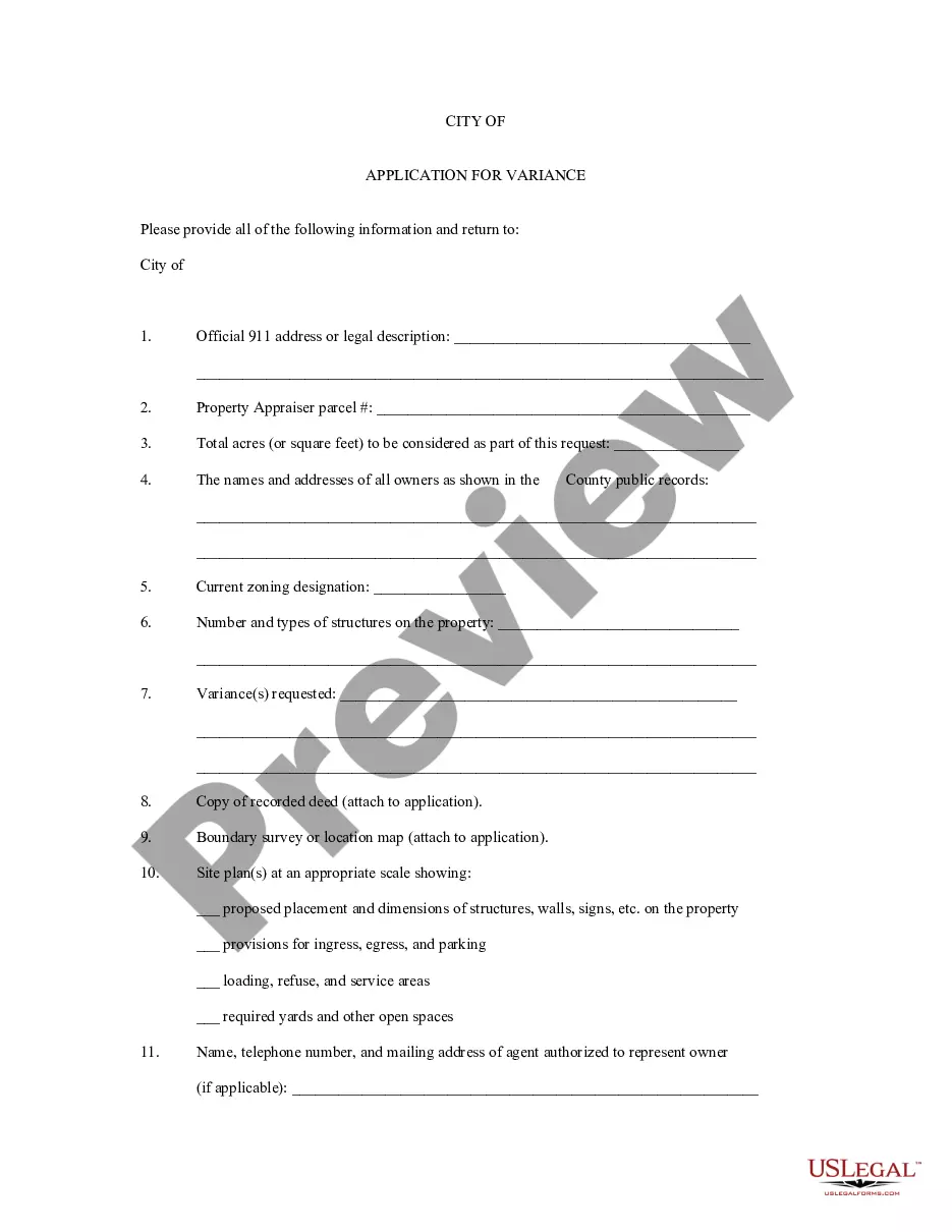
How to fill out Application For Rezoning And / Or Future Land Use Map Amendment?
Choosing the best authorized record template might be a have a problem. Obviously, there are plenty of web templates available on the net, but how do you discover the authorized kind you require? Make use of the US Legal Forms site. The support delivers 1000s of web templates, for example the Hawaii Application for Rezoning and / or Future Land Use Map Amendment, that you can use for company and private demands. Each of the forms are examined by specialists and meet federal and state needs.
When you are already registered, log in in your bank account and click on the Download option to find the Hawaii Application for Rezoning and / or Future Land Use Map Amendment. Utilize your bank account to search throughout the authorized forms you might have bought formerly. Go to the My Forms tab of your bank account and have one more backup of the record you require.
When you are a fresh user of US Legal Forms, listed here are simple recommendations that you can comply with:
- Very first, make sure you have selected the proper kind to your city/region. You may look over the shape utilizing the Review option and browse the shape information to make certain it will be the best for you.
- If the kind does not meet your expectations, take advantage of the Seach industry to obtain the appropriate kind.
- When you are certain the shape would work, click the Buy now option to find the kind.
- Pick the prices strategy you would like and enter in the required information. Make your bank account and purchase the order making use of your PayPal bank account or credit card.
- Pick the data file format and obtain the authorized record template in your gadget.
- Full, edit and print and indication the attained Hawaii Application for Rezoning and / or Future Land Use Map Amendment.
US Legal Forms is the most significant library of authorized forms in which you can find different record web templates. Make use of the company to obtain appropriately-produced documents that comply with status needs.
Form popularity
FAQ
(a) The purpose of the preservation districts is to preserve and manage major open space and recreation lands, and lands of scenic and other natural resource value. (b) It is intended that all lands within a State-designated conservation district be zoned P-1 restricted preservation district.
1a. gricultural District (minimum building site of 1 acre) 200a. gricultural District (minimum building site of 200 acres)
1a. gricultural District (minimum building site of 1 acre) 200a. gricultural District (minimum building site of 200 acres)
Ing the Hawaii Data Book, there is an approximate total of 4,112,388 acres of land in the State of Hawaii, of which about 48 percent is designated as conservation, 47 percent is designated as agricultural, 5 percent is designated as urban, and less and 1/2 percent is designated as rural.
Zoning Code. The Hawai'i County Code Chapter 25 is known as the "Zoning Code." It defines permitted land uses within the State Land Use "Urban" and "Agricultural" classifications. For each Zoning district, the Code spells out required building setbacks, height limits, and other constraints.
The purpose of the AG-1 (agricultural-1) zoning district is to conserve and protect open land uses, foster orderly growth in rural areas and prevent urban agricultural land use conflicts.
The numbers are the minimum square footage or minimum acreage of land. RS-7.5 means residential, minimum land area 7,500sq. ft.. RS-10 is residential, minimum land area 10,000sq.