Loading
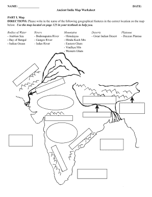
Get Iredell-statesville School Ancient India Map Worksheet
How it works
-

Open form follow the instructions
-

Easily sign the form with your finger
-

Send filled & signed form or save
How to fill out the Iredell-Statesville School Ancient India Map Worksheet online
Completing the Iredell-Statesville School Ancient India Map Worksheet online is an important educational task that helps users engage with geographical concepts from Ancient India. This guide provides clear, step-by-step instructions to ensure you can fill out the worksheet accurately and efficiently.
Follow the steps to successfully complete your worksheet online.
- Click the ‘Get Form’ button to access the worksheet and open it in the online editor.
- In the first section, labeled 'Map', you will need to identify and write the names of specific geographical features. Refer to page 125 of your textbook as a guide for correct placement. Enter the names of bodies of water, rivers, mountains, deserts, and plateaus in the designated areas on the map.
- Proceed to 'Map Interpretation & Analysis'. Here, you will answer a series of questions using information from the map. Carefully read each question and provide clear, concise answers in the spaces provided.
- After you have filled out the entire worksheet, review your entries for accuracy and completeness.
- Once confirmed, you can save your changes, download, print, or share the worksheet as needed to complete your assignment.
Start filling out your Iredell-Statesville School Ancient India Map Worksheet online today!
Please note that there are two calendars, one for traditional schools, and one for our three early college campuses. The 2020-2021 school year will begin on August 5, 2020 and culminate on May 26.