We use cookies to improve security, personalize the user experience, enhance our marketing activities (including cooperating with our marketing partners) and for other business use.
Click "here" to read our Cookie Policy. By clicking "Accept" you agree to the use of cookies. Read less
Read more
Accept
Loading
Form preview
  • US Legal Forms
  • Form Library
  • Executive Forms
  • Executive Department DOD Forms
  • Wetland Determination Data Form- Eastern Mountains And Piedmont

Get Wetland Determination Data Form- Eastern Mountains And Piedmont

L relief (concave, convex, none): Landform (hillslope, terrace, etc.): Subregion (LRR or MLRA): Lat: none Slope (%): Long: Datum: Soil Map Unit Name: NWI classification: Are climatic / hydrologic conditions on the site typical for this time of year? Yes No (If no, explain in Remarks.) Are Vegetation , Soil , or Hydrology significantly disturbed? Are “Normal Circumstances” present? Yes Are Vegetation , Soil , or Hydrology naturally problematic? (If needed, explain any ans.

How it works

  1. Open form

    Open form follow the instructions

  2. Easily sign form

    Easily sign the form with your finger

  3. Share form

    Send filled & signed form or save

How to fill out the Wetland Determination Data Form - Eastern Mountains and Piedmont online

Completing the Wetland Determination Data Form for the Eastern Mountains and Piedmont can seem daunting, but with clear guidance, you can fill it out effectively. This guide offers step-by-step instructions to help you navigate through the form confidently.

Follow the steps to complete your form online.

  1. Click ‘Get Form’ button to access the Wetland Determination Data Form for the Eastern Mountains and Piedmont.
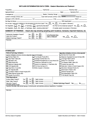
  2. Fill in the project information, including 'City/County,' 'Project/Site,' 'Sampling Date,' and 'Applicant/Owner.' This information identifies the specific site and parties involved.
  3. Provide 'Investigator(s)' names, 'Sampling Point,' and details about the 'Section, Township, Range.' Additionally, describe 'Local relief' and 'Landform' characteristics.
  4. Indicate the 'Lat' and 'Long' coordinates for your sampling site and the appropriate datum.
  5. Complete the soil map unit and NWI classification. Answer whether climatic/hydrologic conditions are typical for the season, checking 'Yes' or 'No.' If 'No,' provide an explanation in 'Remarks.'
  6. Assess whether vegetation, soil, or hydrology is significantly disturbed and whether 'Normal Circumstances' are present, marking the appropriate options. Use 'Remarks' for clarifications.
  7. In the summary section, attach a site map indicating sampling point locations and significant features. Assess the presence of 'Hydrophytic Vegetation,' 'Hydric Soil,' and 'Wetland Hydrology,' checking 'Yes' or 'No' as applicable.
  8. For the hydrology section, identify indicators, differentiating between primary and secondary indicators of wetland hydrology, checking all that apply.
  9. Complete the vegetation section by documenting the five strata: Tree, Sapling, Shrub, Herb, and Woody Vine, including the scientific names and relevant data for each.
  10. Describe the soil profile, including depth, color, and texture, and assess whether hydric soil indicators are present.
  11. Finally, review all information entered in the form for accuracy. You can choose to save your changes, download, print, or share your completed form as needed.

Begin filling out the Wetland Determination Data Form online today for a streamlined experience.

Get form

Experience a faster way to fill out and sign forms on the web. Access the most extensive library of templates available.
Get form

Related content

WETLAND DETERMINATION DATA FORM
WETLAND DETERMINATION DATA FORM – Eastern Mountains and Piedmont Region ... Eastern...
Learn more
Eastern Mountains and Piedmon
Eastern Mountains and Piedmont – Interim Version. WETLAND DETERMINATION DATA FORM –...
Learn more
Wadeable Streams Assessment
May 16, 2007 — The Eastern Highlands region presents the most concerns, with only 18% of...
Learn more

Related links form

AATM 2008 STATE ALGEBRA CONTEST.doc - Oak Ucc Nau Where Do You Mail A Revenue Form K 4 To Equipment Transfer Form Tutoring Session Self-Evaluation Form - Learning Assistance ... - Lap Nku

Questions & Answers

Get answers to your most pressing questions about US Legal Forms API.

Contact support

The 50/20 rule in wetland delineation specifies that wetland areas must demonstrate certain characteristics, including specific vegetation and soil types over a defined percentage of the area. Specifically, at least 50% of the area should exhibit wetland traits, with hydric soils present across 20% of the site. Utilizing the Wetland Determination Data Form- Eastern Mountains and Piedmont can facilitate your understanding and application of this rule.

Parameters for wetland delineation include evaluating hydrological conditions, assessing soil types, and identifying plant communities. Each factor plays a critical role in determining whether an area is classified as a wetland. To ensure accuracy in this assessment, the Wetland Determination Data Form- Eastern Mountains and Piedmont serves as an essential tool, guiding you through the necessary evaluations.

The three criteria used for wetland delineation include hydrology, soil type, and vegetation. Specifically, an area must demonstrate signs of wetland hydrology, possess hydric soils, and support wetland plant species. Understanding these criteria is vital, and utilizing the Wetland Determination Data Form- Eastern Mountains and Piedmont can assist you in accurately assessing these features.

A jurisdictional determination of wetlands is an assessment that identifies whether a particular area meets the legal criteria for being classified as a wetland. This designation is crucial because it affects land use and development regulations. By completing a Wetland Determination Data Form- Eastern Mountains and Piedmont, you can clarify the status of your property and navigate any associated legal requirements.

The determination of what qualifies as a wetland typically falls to professionals, such as environmental consultants and officials from governmental agencies. These experts utilize the guidelines detailed in the Wetland Determination Data Form- Eastern Mountains and Piedmont for accurate evaluations. By engaging with certified professionals, you can ensure reliable assessments of your land's wetland status.

You can obtain a wetland delineation certificate by first filling out the Wetland Determination Data Form- Eastern Mountains and Piedmont. This form assists in documenting the extent and boundaries of any wetland areas on your property. After submission, a qualified expert will evaluate your delineation and issue the certificate, ensuring you meet all regulatory requirements.

To secure wetland certification, you typically need to submit a completed Wetland Determination Data Form- Eastern Mountains and Piedmont through a recognized agency or organization. This process may include an on-site assessment to verify wetland conditions. By using our USLegalForms platform, you can simplify this process and ensure all appropriate documents are submitted correctly.

Obtaining a wetlands determination generally involves completing a Wetland Determination Data Form- Eastern Mountains and Piedmont, which you can find on our USLegalForms platform. You'll need to provide specific information about your property, including location and current land use. After submission, a qualified professional will review your application and provide a determination on the status of wetlands on your property.

For an area to qualify as a wetland, it must demonstrate three specific conditions: hydrology, which involves the presence of water; hydric soils, which are waterlogged for substantial periods; and wetland vegetation, which consists predominantly of plants suited to wet environments. These criteria form the basis of the Wetland Determination Data Form- Eastern Mountains and Piedmont, helping you gain clarity about your land's designation.

The 50/20 rule refers to the concept that at least 50% of the vegetation in a wetland area must consist of plants that thrive in wet conditions, while no more than 20% should consist of invasive species. This rule helps assess wetland health and can be crucial when completing the Wetland Determination Data Form- Eastern Mountains and Piedmont. Following this guideline ensures accurate evaluation of wetland conditions.

Get This Form Now!

Use professional pre-built templates to fill in and sign documents online faster. Get access to thousands of forms.
Get form
If you believe that this page should be taken down, please follow our DMCA take down processhere.

Industry-leading security and compliance

US Legal Forms protects your data by complying with industry-specific security standards.
  • In businnes since 1997
    25+ years providing professional legal documents.
  • Accredited business
    Guarantees that a business meets BBB accreditation standards in the US and Canada.
  • Secured by Braintree
    Validated Level 1 PCI DSS compliant payment gateway that accepts most major credit and debit card brands from across the globe.
Get Wetland Determination Data Form- Eastern Mountains and Piedmont
Get form
Form Packages
Adoption
Bankruptcy
Contractors
Divorce
Home Sales
Employment
Identity Theft
Incorporation
Landlord Tenant
Living Trust
Name Change
Personal Planning
Small Business
Wills & Estates
Packages A-Z
Form Categories
Affidavits
Bankruptcy
Bill of Sale
Corporate - LLC
Divorce
Employment
Identity Theft
Internet Technology
Landlord Tenant
Living Wills
Name Change
Power of Attorney
Real Estate
Small Estates
Wills
All Forms
Forms A-Z
Form Library
Customer Service
Terms of Service
Privacy Notice
Legal Hub
Content Takedown Policy
Bug Bounty Program
About Us
Blog
Affiliates
Contact Us
Delete My Account
Site Map
Industries
Forms in Spanish
Localized Forms
State-specific Forms
Forms Kit
Legal Guides
Real Estate Handbook
All Guides
Prepared for You
Notarize
Incorporation services
Our Customers
For Consumers
For Small Business
For Attorneys
Our Sites
US Legal Forms
USLegal
FormsPass
pdfFiller
signNow
airSlate WorkFlow
DocHub
Instapage
Social Media
Call us now toll free:
+1 833 426 79 33
As seen in:
  • USA Today logo picture
  • CBC News logo picture
  • LA Times logo picture
  • The Washington Post logo picture
  • AP logo picture
  • Forbes logo picture
© Copyright 1997-2025
airSlate Legal Forms, Inc.
3720 Flowood Dr, Flowood, Mississippi 39232