Loading
Get Map Analysis Worksheet
How it works
-

Open form follow the instructions
-

Easily sign the form with your finger
-

Send filled & signed form or save
How to fill out the Map Analysis Worksheet online
The Map Analysis Worksheet is an essential tool for analyzing various types of maps. This guide will walk you through the online process of completing this worksheet, ensuring you understand each section and field for accurate submissions.
Follow the steps to complete the Map Analysis Worksheet.
- Click the ‘Get Form’ button to access the Map Analysis Worksheet and open it in your preferred online document editor.
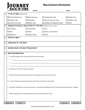
- Begin by entering your name and the date in the designated fields at the top of the worksheet.
- In the TYPE OF MAP section, select one option from the list provided. Options include raised relief map, birds-eye map, topographic map, and more. You can check only one box that best represents your map.
- Next, under UNIQUE PHYSICAL QUALITIES OF THE MAP, check one or more attributes that describe your map. This could include features such as a compass, title, date, scale, and more. Select all that apply.
- Fill in the DATE OF MAP and CREATOR OF THE MAP fields with relevant information about when the map was created and who made it.
- Indicate WHERE WAS THE MAP PRODUCED by providing the location where the map was created.
- In the MAP INFORMATION section, answer each question thoughtfully: A. List three important things in this map; B. Explain why you think this map was drawn; C. Describe the information this map adds to the textbook’s account of the event; D. Provide two insights the document reveals about life at the time it was created; E. State whether the map information supports or contradicts previous readings on the event; F. Write a question that remains unanswered by this map.
- Once you have completed all sections, you can save changes, download, print, or share the Map Analysis Worksheet using the appropriate options.
Begin filling out your Map Analysis Worksheet online today!
A map analysis is a study regarding map types, i.e. political maps, military maps, contour lines etc., and the unique physical qualities of a map, i.e. scale, title, legend etc. It is also a way of decoding the message and symbols of the map and placing it within its proper spatial and cultural context.