Loading
Get Data/map Request
How it works
-

Open form follow the instructions
-

Easily sign the form with your finger
-

Send filled & signed form or save
How to fill out the DATA/MAP REQUEST online
Filling out the DATA/MAP REQUEST form is a straightforward process that allows you to request important information from the Washington County Planning Department. This guide provides clear, step-by-step instructions to ensure your request is submitted accurately and efficiently.
Follow the steps to complete your request successfully.
- Click ‘Get Form’ button to retrieve the DATA/MAP REQUEST form and access it online.
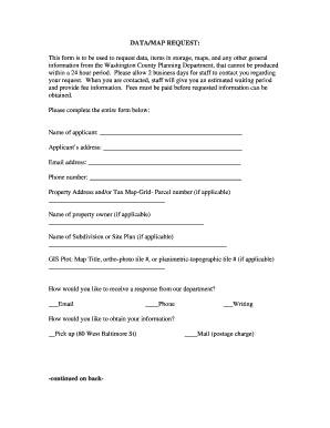
- Fill in the 'Name of applicant' field with your full name. This identifies you as the requester.
- Enter your 'Applicant’s address' in the designated space to provide a contact location.
- Input your 'Email address' to ensure you receive any correspondence regarding your request.
- Provide your 'Phone number' so that staff can reach you if needed.
- If applicable, specify the 'Property Address and/or Tax Map-Grid-Parcel number' for the information request.
- Complete the 'Name of property owner' section if it differs from your own.
- For GIS Plot details, fill in the 'Map Title, ortho-photo tile #, or planimetric-topographic tile #' as necessary.
- Choose your preferred method of response by checking the appropriate box: Email, Phone, or Writing.
- Indicate how you would like to obtain your information: Pick up from the office or by Mail (with a note about the postage charge).
- In the 'Information Requested' section, be as specific as possible regarding the data or items you are requesting. Provide as much detail as necessary.
- Once you have completed the form, review all entries for accuracy.
- Finally, save your changes, download, print, or share the form as required before submitting.
Complete your DATA/MAP REQUEST online now and ensure your information is processed efficiently.
To get data from an ArcGIS map, you can use ArcGIS REST API to request specific data layers. By specifying the layer and the parameters, you can tailor your DATA/MAP REQUEST to suit your needs. Familiarizing yourself with the ArcGIS interface makes this process more streamlined.
Industry-leading security and compliance
US Legal Forms protects your data by complying with industry-specific security standards.
-
In businnes since 199725+ years providing professional legal documents.
-
Accredited businessGuarantees that a business meets BBB accreditation standards in the US and Canada.
-
Secured by BraintreeValidated Level 1 PCI DSS compliant payment gateway that accepts most major credit and debit card brands from across the globe.