Get Wetland Determination Data Form-arid
How it works
-

Open form follow the instructions
-

Easily sign the form with your finger
-

Send filled & signed form or save
How to fill out the Wetland Determination Data Form-Arid online
Filling out the Wetland Determination Data Form-Arid is critical for assessing wetland status within arid regions. This guide provides you with step-by-step instructions to assist you in completing the form accurately and efficiently.
Follow the steps to complete the Wetland Determination Data Form-Arid online.
- Click the ‘Get Form’ button to access the Wetland Determination Data Form-Arid and launch it in the editor.
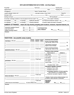
- Begin by entering the details for the City/County and Project/Site fields. It is important to provide accurate information for proper identification.
- Next, indicate the Sampling Date and State where the sampling will take place. This ensures compliance with regulatory timelines.
- Input the Applicant/Owner's name and the names of all Investigator(s) involved in the study. This identifies who is responsible for the form.
- Fill in the Section, Township, and Range details related to the sampling location. This information is necessary for geographic referencing.
- Describe the Landform. Select from options like hillslope or terrace to characterize the location accurately.
- Provide information on Local Relief, indicating if it is concave, convex, or none, to highlight the area's topographical features.
- Enter the latitude (Lat) and longitude (Long) of the site to assist in precise geographical referencing.
- Specify the Datum to use for the coordinates, as this is vital for geographical accuracy.
- Indicate the NWI classification if applicable. This classifies wetland types based on federal standards.
- Answer questions regarding climatic and hydrologic conditions, indicating if they are typical for the season. Provide explanations in the Remarks if conditions are not typical.
- Assess and answer the inquiries about the disturbance of Vegetation, Soil, or Hydrology and whether 'Normal Circumstances' are present.
- Complete the Summary of Findings by attaching a site map that shows sampling point locations, transects, and other important features.
- In the Vegetation section, enter all relevant data regarding tree, shrub, herb stratum, and woody vine stratum, including species and coverage metrics.
- Detail the Soil Profile Description, including matrix color and texture, while ensuring to note any hydric soil indicators.
- In the Hydrology section, check the appropriate box for primary and secondary indicators of wetland hydrology present at the sampling site.
- Conclude by reviewing all the provided details for accuracy, then save your changes. You can download, print, or share the completed form as needed.
Complete the Wetland Determination Data Form-Arid online today to ensure accurate wetland assessments.
Wetland determination is the process of identifying whether an area is a wetland based on established criteria, while delineation refers to mapping the precise boundaries of the wetland area. Understanding both concepts is essential for compliance and effective project planning. Utilizing the Wetland Determination Data Form-Arid helps clarify these processes and offers a comprehensive framework for your projects.