Loading
Get Staar Science Tutorial 34 - Tek 8.9c
How it works
-

Open form follow the instructions
-

Easily sign the form with your finger
-

Send filled & signed form or save
How to use or fill out the STAAR Science Tutorial 34 - TEK 8.9C online
The STAAR Science Tutorial 34 - TEK 8.9C is designed to help users interpret topographic maps and understand erosional landforms. This guide provides step-by-step instructions for filling out the form online to ensure a smooth and effective experience.
Follow the steps to successfully complete the STAAR Science Tutorial 34 - TEK 8.9C form.
- Press the ‘Get Form’ button to access the STAAR Science Tutorial 34 - TEK 8.9C form and open it for editing.
- Begin by entering your name in the designated field at the top of the form. This identifies you as the person completing the tutorial.
- Next, fill in the teacher's name in the appropriate section. This helps recognize the instructor associated with your work.
- Indicate your class period in the designated space provided. This information is necessary for classroom tracking.
- Write the current date in the space provided, ensuring that all records are time-stamped accurately for review purposes.
- Proceed to the content sections of the form, which include a variety of questions related to topographic maps and erosional landforms. Carefully read each question and provide the answers based on your understanding and interpretation from the tutorial material.
- As you complete each question, utilize the tutorial's context to guide your responses, ensuring clarity and accuracy in your answers.
- When you have filled in all the necessary information, make sure to review your responses for any errors or omissions.
- Finally, decide how you would like to save or share your completed form. Options may include saving changes, downloading, printing, or sharing the document electronically.
Take the next step and complete your STAAR Science Tutorial 34 - TEK 8.9C online for successful submission.
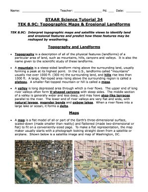
In hilly areas, the contour lines are close together while they are wider apart on flat slopes. The closer the contour lines, the steeper the slope. The wider the contour lines, the flatter the slopes. On a hill, the contour lines form circles; whereby the values of their elevation increase from the edge to the centre.