Loading
Get Wetland Determination Data Form
How it works
-

Open form follow the instructions
-

Easily sign the form with your finger
-

Send filled & signed form or save
How to fill out the Wetland Determination Data Form online
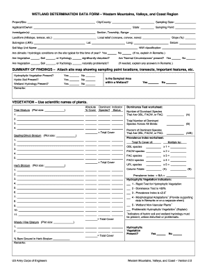
The Wetland Determination Data Form is an essential document for assessing wetland areas in the Western Mountains, Valleys, and Coast Region. This guide provides clear, step-by-step instructions on how to complete the form effectively while filing it online.
Follow the steps to fill out the Wetland Determination Data Form online.
- Use the ‘Get Form’ button to access the Wetland Determination Data Form and display it in the editor for completion.
- Fill in the project or site details, including the city or county, state, and applicant or owner. Include the necessary information about the sampling date and investigator(s).
- Provide geographical information, specifying the section, township, range, local relief (concave, convex, or none), and the geographic coordinates (latitude and longitude).
- In the Soil section, indicate whether climatic or hydrologic conditions are typical by selecting 'Yes' or 'No.' If 'No', provide an explanation in the 'Remarks' section.
- Complete the evaluation of vegetative, soil, or hydrology disturbances and determine if they meet the 'Normal Circumstances' criteria. Follow up with any necessary explanations in the 'Remarks.'
- In the summary of findings, indicate the presence of hydrophytic vegetation, hydric soil, and wetland hydrology by selecting 'Yes' or 'No' for each. Confirm whether the sampled area is within a wetland.
- For the vegetation section, list the scientific names of plants you observed. Provide details for tree stratum, sapling/shrub stratum, and herb stratum, including cover percentages and dominant species information.
- Detail the soil characteristics by documenting matrix color, texture, and the presence of hydric soil indicators. Make sure to provide descriptions down to the sufficient depth.
- Identify wetland hydrology indicators, checking all applicable primary and secondary indicators. Document your field observations about surface water, water table presence, and saturation.
- Finish by reviewing all sections for completeness and accuracy. Save changes, download the completed form, or print it for submission as needed.
Get started on your Wetland Determination Data Form online today!
The three criteria for classifying a wetland include hydrology, soil type, and vegetation. Specifically, an area must have sufficient water presence, hydric soils, and plant species adapted to saturated conditions. Completing the Wetland Determination Data Form helps gather this critical information, ensuring that you effectively meet the criteria for wetland designation.