Get Fema 81-31 2009-2026
How it works
-

Open form follow the instructions
-

Easily sign the form with your finger
-

Send filled & signed form or save
How to fill out the FEMA 81-31 online
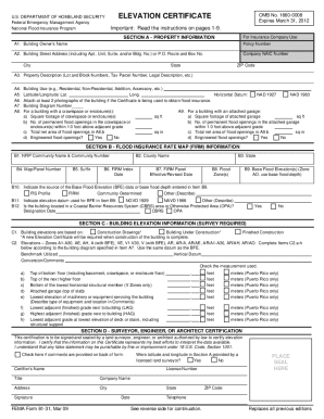
The FEMA 81-31 Elevation Certificate is a vital document for obtaining flood insurance and ensuring compliance with community floodplain management regulations. This guide provides a clear and supportive walkthrough for filling out the form online.
Follow the steps to successfully complete the FEMA 81-31 Elevation Certificate.
- Click ‘Get Form’ button to access the FEMA 81-31 Elevation Certificate and open it in your preferred editor.
- Section A requires property information. Users should enter the building owner's name, street address, property description, and building use. Ensure accuracy to facilitate correct insurance rating.
- In Section B, complete the Flood Insurance Rate Map (FIRM) information. Enter the NFIP community name, county, state, and relevant map details. Refer to your building’s location on the FIRM for assistance.
- Proceed to Section C, where building elevation information must be included based on a survey. Ensure that all relevant elevations are recorded accurately, using the appropriate flood zone information.
- In Section D, the certifier (land surveyor, engineer, or architect) must provide their details, including name, license number, and signature to certify the information provided.
- If applicable, fill out Section E for buildings in Zones AO or A without BFE. Input the appropriate elevation information and check the necessary boxes.
- Complete Sections F and G if the property owner or community official is certifying additional information. Ensure all signatures and dates are included.
- Finally, review all sections for accuracy, save your changes, and explore options to download, print, or share the completed form.
Start filling out the FEMA 81-31 online for your flood insurance needs today!
FEMA flood zone codes categorize various areas based on their flood risks. These codes include designations like A, V, and X, indicating different levels of risk and regulatory requirements. Knowing these zones allows property owners and developers to understand the potential flood risk and necessary precautions. USLegalForms offers resources to help you identify your flood zone and understand your compliance obligations under FEMA 81-31.