Loading
Get Chapter 14 Watershed Boundaries Answer Key
How it works
-

Open form follow the instructions
-

Easily sign the form with your finger
-

Send filled & signed form or save
How to fill out the Chapter 14 Watershed Boundaries Answer Key online
Filling out the Chapter 14 Watershed Boundaries Answer Key online is a straightforward process that allows users to engage with the material effectively. This guide provides step-by-step instructions to help you navigate the form and understand each component clearly.
Follow the steps to successfully complete the answer key online.
- Press the ‘Get Form’ button to access the Chapter 14 Watershed Boundaries Answer Key and open it in your preferred editor.
- Begin by filling in your personal information at the top of the form, including your name, class, and date. Make sure to provide accurate information.
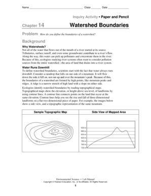
- Move on to the inquiry activity section where you will define the boundaries of a watershed. Read the background information carefully to understand the context.
- In the 'Build Map Skills' section, follow the instructions to read the topographical map. Pay special attention to the contour lines as they are crucial for marking watershed boundaries.
- Sketch the side view of the mountain as requested, then identify and note the lowest and highest elevations shown on the map.
- Draw a line that connects the peaks on the map, ensuring it runs along the highest points of land. Remember to cross elevation lines at right angles.
- Lightly shade the area within your drawn boundary. This visual representation will help clarify the watershed area.
- Mark arrows along the river to indicate the direction of flow. This part is essential for understanding the area’s hydrology.
- Once all sections are complete, review your answers carefully. Save any changes made to the form to ensure your responses are not lost.
- Finally, you can choose to download, print, or share the completed form as needed.
Complete your documents online to improve your efficiency and ensure accuracy.
Ridges and hills that separate two watersheds are called the drainage divide.