Loading
Get Forecasting Weather Map Worksheet
How it works
-

Open form follow the instructions
-

Easily sign the form with your finger
-

Send filled & signed form or save
How to fill out the Forecasting Weather Map Worksheet online
The Forecasting Weather Map Worksheet is a valuable tool for analyzing and predicting weather patterns. This guide will provide clear, step-by-step instructions on how to fill out the worksheet effectively in an online format.
Follow the steps to complete the Forecasting Weather Map Worksheet online.
- Click ‘Get Form’ button to access the Forecasting Weather Map Worksheet and open it in your online editor.
- Begin with the personal information section, where you will enter your name, date, and class period. This helps organize your submission and ensures it is associated with your profile.
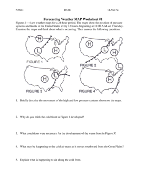
- Review the provided weather maps carefully. Take note of the different pressure systems and fronts as you will need this information for subsequent questions.
- Answer the questions regarding the movement of high and low-pressure systems based on the observations from the maps. This section will require you to synthesize information observed from the visual data.
- Complete the questions regarding the development of fronts. Reflect on the conditions that lead to the formation of cold and warm fronts as shown in the figures.
- Evaluate the expected weather conditions for various states mentioned in the worksheet. Provide informed predictions based on your analysis of the weather maps.
- When answering questions about specific cities, use the data from the weather maps to estimate temperatures, weather conditions, and any anticipated changes.
- Once all questions are answered, review your work for completeness and accuracy. Make any necessary edits to ensure clarity and precision.
- Finally, save your changes, then download, print, or share the completed Forecasting Weather Map Worksheet as required.
Start completing your documents online for a streamlined experience.
Related links form
A climate map shows information about the climate of an area. These maps can show things like the specific climatic zones of an area based on the temperature, the amount of snow an area receives, or the average number of cloudy days. These maps normally use colors to show different climatic areas.