Loading
Get Proposed Certificate Of Elevation - City Of Baton Rouge/parish Of East ...
How it works
-

Open form follow the instructions
-

Easily sign the form with your finger
-

Send filled & signed form or save
How to fill out the Proposed Certificate Of Elevation - City Of Baton Rouge/Parish Of East Baton Rouge online
Filling out the Proposed Certificate Of Elevation is a crucial step in ensuring that your construction project complies with elevation requirements. This guide provides a clear, step-by-step process to help you accurately complete the form online, making it easier for you to navigate through the necessary information.
Follow the steps to complete the form online.
- Click ‘Get Form’ button to obtain the form and open it in the editor.
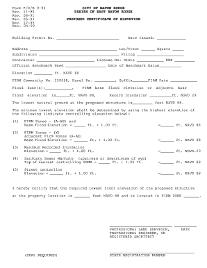
- Enter the building permit number in the designated field. This number is crucial for tracking your application.
- Fill in the date the permit was issued. This information helps establish the timeline for your project.
- Provide the full address of the proposed site, including the lot or tract number and the square. Accuracy in this section is important for identification purposes.
- Input the subdivision name and filing number. These details help in pinpointing the exact location within local records.
- Complete the contractor section by providing the name and license number. Include the state and the East Baton Rouge license number as well.
- Document the official benchmark used and the date of the benchmark datum. This ensures compliance with local elevation standards.
- Indicate the elevation using NAVD 88 and the Community number along with panel number of the FIRM.
- Fill in the flood zones applicable to your project, including the base flood elevation from the FIRM. Specify the recorded inundation if necessary.
- Calculate and input the minimum lowest elevation based on the controlling elevations outlined in the available options. Ensure you indicate the relevant values accurately.
- Certify the required lowest floor elevation of the proposed structure and confirm its location within the FIRM zone.
- The form must be completed by a professional land surveyor, professional engineer, or registered architect. Ensure that their signature, date, and state registration number are included, and attach the required seal.
- After completing all sections, you can save changes, download, print, or share the completed form as needed.
Complete your Proposed Certificate Of Elevation online today to ensure your project meets all elevation regulations.
Pricing in most areas is $245 for standard residential properties. Outlying properties, commercial properties, and additional structures slightly higher.
Industry-leading security and compliance
US Legal Forms protects your data by complying with industry-specific security standards.
-
In businnes since 199725+ years providing professional legal documents.
-
Accredited businessGuarantees that a business meets BBB accreditation standards in the US and Canada.
-
Secured by BraintreeValidated Level 1 PCI DSS compliant payment gateway that accepts most major credit and debit card brands from across the globe.