We use cookies to improve security, personalize the user experience, enhance our marketing activities (including cooperating with our marketing partners) and for other business use.
Click "here" to read our Cookie Policy. By clicking "Accept" you agree to the use of cookies. Read less
Read more
Accept
Loading
Form preview
  • US Legal Forms
  • Form Library
  • More Forms
  • More Multi-State Forms
  • Student Exploration Weather Maps

Get Student Exploration Weather Maps

Name: Date: Student Exploration: Weather Maps Vocabulary: air mass, air pressure, cold front, highpressure system, knot, lowpressure system, precipitation, warm front Prior Knowledge Questions (Do.

How it works

  1. Open form

    Open form follow the instructions

  2. Easily sign form

    Easily sign the form with your finger

  3. Share form

    Send filled & signed form or save

How to fill out the Student Exploration Weather Maps online

This guide provides a comprehensive overview of how to effectively fill out the Student Exploration Weather Maps form online. By following these instructions, users will understand each section of the form and how to provide the necessary information accurately.

Follow the steps to complete the Student Exploration Weather Maps

  1. Click ‘Get Form’ button to obtain the form and open it in the editor.
  2. Begin with the 'Name' field by entering your full name. This field identifies the student participating in the exploration.
  3. Fill in the 'Date' field with the current date to accurately reflect when the exploration is being conducted.
  4. Answer the prior knowledge questions related to the weather. Provide thoughtful responses to both questions to demonstrate your understanding.
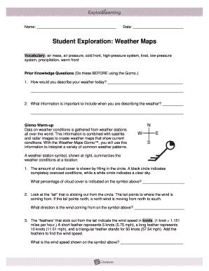
  5. Move on to the 'Gizmo Warm-up' section. Observe the weather station symbol and describe the cloud cover percentage and wind direction as requested.
  6. In Activity A, follow prompts to analyze high-pressure systems. Observe air pressure, cloud cover, and sketch the wind directions and speeds accordingly.
  7. Proceed to Activity B regarding low-pressure systems. Observe changes in air pressure, cloud cover, and measure wind direction and speed.
  8. In Activity C, complete the tasks related to cold and warm fronts, including sketching, observing conditions, and analyzing the patterns seen.
  9. Once all sections are filled out, review your responses to ensure accuracy and completeness.
  10. You can now save your changes, download, print, or share the form as needed.

Complete the Student Exploration Weather Maps online to enhance your understanding of weather patterns.

Get form

Experience a faster way to fill out and sign forms on the web. Access the most extensive library of templates available.
Get form

Related content

Educational resources - National Weather Service
Check out this cloud chart to better understand what's going on high up in the sky!...
Learn more
S1 Planning Guide: Weather Topic Exploring Weather...
Topic, Exploring Weather Maps and Symbols and Predicting Weather. Level, Introduction...
Learn more
Andrée's Arctic balloon expedition - Wikipedia
Andrée's Arctic balloon expedition of 1897 was an effort to reach the North Pole in which...
Learn more

Related links form

Holiday Budget Planner Expense Trends Tips Template T-Ledger Account Sheet Small Business Accounts Sheet

Questions & Answers

Get answers to your most pressing questions about US Legal Forms API.

Contact support

Another name for a weather map is a meteorological chart. This term encompasses various maps that convey weather data, including temperature, precipitation, and wind speed. Utilizing Student Exploration Weather Maps can give you clear insights into these conditions and keep you informed.

Synoptic weather maps are particularly useful in demonstrating weather patterns across a broad area. They provide a snapshot of various meteorological factors such as pressure systems and fronts. Engaging with Student Exploration Weather Maps equips you with this critical information for making educated choices.

Isotherm maps, which connect points of equal temperature, are highly effective for showing weather patterns. These maps visually represent temperature changes over different areas. By using Student Exploration Weather Maps, you can easily access isotherm data along with other weather information to inform your activities.

A warm front occurs when a warm air mass moves into an area occupied by cooler air. As the warm air rises, it leads to cloud formation and may result in precipitation. Understanding warm fronts enhances your usage of Student Exploration Weather Maps, enabling you to track and prepare for weather changes.

A weather map is specifically designed to display current weather conditions across a region. These maps illustrate temperatures, precipitation, and wind patterns to help viewers understand the climate. Student Exploration Weather Maps are an excellent resource for accessing these vital details.

Meteorologists often use various tools such as satellites, radar, and computer models to predict weather patterns. These tools analyze atmospheric conditions and generate forecasts. Student Exploration Weather Maps integrate data from these sources, providing users with an up-to-date picture of weather changes.

The most accurate weather map typically combines various data sources to show current conditions, forecasts, and predictions. These maps utilize advanced technology and models to provide real-time updates. For users engaging with Student Exploration Weather Maps, accuracy is crucial for planning outdoor activities or making important decisions.

When describing the weather, include key details such as temperature, humidity levels, wind speed, and chances of precipitation. Mentioning any significant weather phenomena enhances the description. Student Exploration Weather Maps provide an interactive way to gather and present this crucial information effectively.

The lines on a weather map, known as isobars, indicate areas of equal pressure, while isotherms represent areas of equal temperature. These lines help meteorologists understand weather patterns and predict changes. By using Student Exploration Weather Maps, you can visually appreciate how these lines interact and impact local weather.

Reading surface wind maps requires understanding the wind direction and speed indicated by arrows. These arrows show the flow of air, which can affect weather patterns and temperatures. Student Exploration Weather Maps make it easy to interpret these essential features, ensuring you can predict weather conditions confidently.

Get This Form Now!

Use professional pre-built templates to fill in and sign documents online faster. Get access to thousands of forms.
Get form
If you believe that this page should be taken down, please follow our DMCA take down processhere.

Industry-leading security and compliance

US Legal Forms protects your data by complying with industry-specific security standards.
  • In businnes since 1997
    25+ years providing professional legal documents.
  • Accredited business
    Guarantees that a business meets BBB accreditation standards in the US and Canada.
  • Secured by Braintree
    Validated Level 1 PCI DSS compliant payment gateway that accepts most major credit and debit card brands from across the globe.
Get Student Exploration Weather Maps
Get form
Form Packages
Adoption
Bankruptcy
Contractors
Divorce
Home Sales
Employment
Identity Theft
Incorporation
Landlord Tenant
Living Trust
Name Change
Personal Planning
Small Business
Wills & Estates
Packages A-Z
Form Categories
Affidavits
Bankruptcy
Bill of Sale
Corporate - LLC
Divorce
Employment
Identity Theft
Internet Technology
Landlord Tenant
Living Wills
Name Change
Power of Attorney
Real Estate
Small Estates
Wills
All Forms
Forms A-Z
Form Library
Customer Service
Terms of Service
Privacy Notice
Legal Hub
Content Takedown Policy
Bug Bounty Program
About Us
Blog
Affiliates
Contact Us
Delete My Account
Site Map
Industries
Forms in Spanish
Localized Forms
State-specific Forms
Forms Kit
Legal Guides
Real Estate Handbook
All Guides
Prepared for You
Notarize
Incorporation services
Our Customers
For Consumers
For Small Business
For Attorneys
Our Sites
US Legal Forms
USLegal
FormsPass
pdfFiller
signNow
airSlate WorkFlow
DocHub
Instapage
Social Media
Call us now toll free:
+1 833 426 79 33
As seen in:
  • USA Today logo picture
  • CBC News logo picture
  • LA Times logo picture
  • The Washington Post logo picture
  • AP logo picture
  • Forbes logo picture
© Copyright 1997-2025
airSlate Legal Forms, Inc.
3720 Flowood Dr, Flowood, Mississippi 39232