Get Mapping The Ocean Floor Lab 2020-2026
How it works
-

Open form follow the instructions
-

Easily sign the form with your finger
-

Send filled & signed form or save
How to fill out the Mapping The Ocean Floor Lab online
This guide provides comprehensive instructions on how to effectively complete the Mapping The Ocean Floor Lab online. Whether you are familiar with digital document management or are encountering this process for the first time, this guide will support you through each step.
Follow the steps to successfully complete the form.
- Click ‘Get Form’ button to access the Mapping The Ocean Floor Lab and open it in the document editing interface.
- Begin by entering your name in the designated field at the top of the form.
- Review the background information and instructions provided within the document to familiarize yourself with the ocean mapping process.
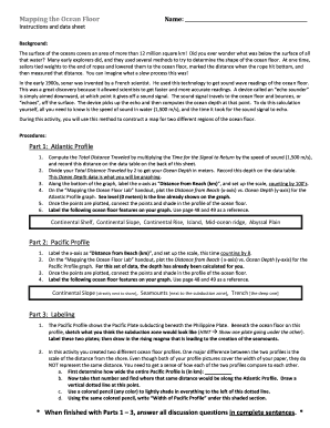
- Proceed to Part 1: Atlantic Profile. Compute the total distance traveled by multiplying the time for the signal to return by the speed of sound in water (1,500 m/s). Enter this value in the appropriate data table.
- Calculate the ocean depth by dividing the total distance traveled by 2, and record this value on the data table.
- Label the x-axis on the graph section as 'Distance from Beach (km)' and establish the scale by counting by 100s.
- On the Mapping The Ocean Floor Lab handout, plot the data points for the Atlantic Profile graph, connecting each point and shading in the profile of the ocean floor.
- Label the ocean floor features including Continental Shelf, Continental Slope, Continental Rise, Island, Mid-ocean ridge, and Abyssal Plain on your graph.
- Move on to Part 2: Pacific Profile. Label the x-axis similarly and plot the given data points for the Pacific Profile graph, connecting and shading the ocean floor as per the instructions.
- Label the following ocean floor features on the graph as specified: Continental Slope, Seamounts, and Trench.
- In Part 3, sketch the subduction zone beneath the ocean floor, label the plates, and illustrate the rising magma associated with the seamounts.
- Complete the discussion questions in complete sentences to finalize the lab activity.
- Once you have filled out all sections and answered the questions, save your changes, download the document, print it if needed, or share it with your instructor as required.
Start completing your Mapping The Ocean Floor Lab document online today!
Scientists map the ocean floor by employing a combination of sonar technology and data analysis methods. In Mapping The Ocean Floor Lab, they analyze the data collected through sound waves to build comprehensive maps of underwater features. This mapping process reveals vital information about ocean currents, tectonic activity, and marine life. By understanding these aspects, we can better protect our ocean environments.