Loading
Get Stream Assessment Field Sketch Form - Watershed Ucdavis
How it works
-

Open form follow the instructions
-

Easily sign the form with your finger
-

Send filled & signed form or save
How to fill out the Stream Assessment Field Sketch Form - Watershed Ucdavis online
Filling out the Stream Assessment Field Sketch Form is a crucial step for ensuring accurate data collection in watershed assessments. This guide will provide you with clear, step-by-step instructions to complete the form effectively and efficiently.
Follow the steps to successfully complete the form.
- Press the ‘Get Form’ button to obtain the form and open it for completion.
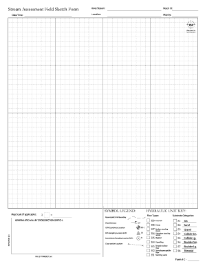
- Begin by entering the date and time of assessment in the provided fields. This information is essential for tracking changes over time.
- Next, specify the river or stream name in the corresponding section. Ensure the name is spelled correctly to avoid confusion.
- Fill in the Reach ID, a unique identifier for the specific stream section being assessed. This helps in organizing assessments for various reaches.
- Indicate the location of the assessment site with as much detail as possible. Include any landmarks or notable features that will assist in future navigation.
- Complete the ‘Map by’ field to indicate who created the data included in the form.
- Draw an arrow representing the north direction on the map section. This is vital for orientation during analysis.
- If applicable, provide a map scale that indicates the proportion between the map and the actual distance. This aids in accurately interpreting the mapped data.
- Utilize the symbol legend and hydraulic unit key to accurately describe the flow types present at the site. Use these keys as a reference when documenting observable conditions.
- Sketch the generalized valley cross-section, indicating elevation and flow direction. This visual representation complements the written data.
- Document the UTM coordinate location for precise geographic referencing.
- Indicate the fish sampling location and ID along with the corresponding invertebrate sampling location and ID to ensure proper identification of data.
- Provide the cross-section location details as required in the form. This should correspond to your earlier sketch.
- Review the substrate categories and select relevant identifiers based on your observations of the riverbed composition.
- Once you have completed all sections, be sure to save changes, and you can download, print, or share your filled form as needed.
Complete your assessments efficiently by filling out the Stream Assessment Field Sketch Form online today.
Related links form
TX Womens Health Specialists Authorization To Disclose Health Information 2020
MN Intensive Residential Treatment Facilities Critical Incident Reporting Form 2010
MN Intensive Residential Treatment Facilities Critical Incident Reporting Form 2018
MN Intensive Residential Treatment Facilities Critical Incident Reporting Form 2013
Industry-leading security and compliance
US Legal Forms protects your data by complying with industry-specific security standards.
-
In businnes since 199725+ years providing professional legal documents.
-
Accredited businessGuarantees that a business meets BBB accreditation standards in the US and Canada.
-
Secured by BraintreeValidated Level 1 PCI DSS compliant payment gateway that accepts most major credit and debit card brands from across the globe.