Loading
Get Computer Science Geographic Information Systems Specialization
How it works
-

Open form follow the instructions
-

Easily sign the form with your finger
-

Send filled & signed form or save
How to fill out the Computer Science Geographic Information Systems Specialization online
This guide provides comprehensive instructions for completing the Computer Science Geographic Information Systems Specialization form. Whether you are a returning student or a new applicant, this step-by-step approach will support you in submitting your application successfully.
Follow the steps to complete your application form effectively.
- Click ‘Get Form’ button to obtain the form and open it in the editor.
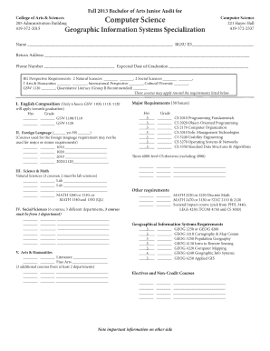
- Begin by entering your name and BGSU ID in the designated fields at the top of the form.
- Fill in your return address accurately to ensure proper correspondence.
- Provide your phone number and expected date of graduation in the appropriate fields.
- Complete the BG Perspective Requirements by checking off the completed courses in the Natural Sciences, Social Sciences, Arts & Humanities, International Perspective, Cultural Diversity, GSW 1120, and Quantitative Literacy sections.
- Under section I, list the English Composition courses you have completed, indicating the hours and grades.
- In section II, record your foreign language experience, noting the number of years in high school and filling in the course details.
- For section III, enter the natural science and math courses you have completed, ensuring two lab sciences are included.
- Proceed to section IV, where you will indicate your completed social science courses, ensuring they meet the specified departmental requirements.
- In section V, specify the literature and fine arts courses, along with additional courses to satisfy the Arts & Humanities requirements.
- Complete the major requirements section by entering the hours and grades for each required Computer Science course.
- Fill out any additional requirements for math and societal impact courses as indicated.
- For geographical information systems requirements, list the required courses and any completed electives.
- Review your completed form thoroughly to ensure all sections are filled out properly.
- Once satisfied, you can save changes, download, print, or share the completed form as needed.
Complete your Computer Science Geographic Information Systems Specialization form online today to ensure your academic progress!
GIS technology can be used to display spatial relationships and linear networks. Spatial relationships may display topography, such as agricultural fields and streams. They may also display land-use patterns, such as the location of parks and housing complexes.
Industry-leading security and compliance
US Legal Forms protects your data by complying with industry-specific security standards.
-
In businnes since 199725+ years providing professional legal documents.
-
Accredited businessGuarantees that a business meets BBB accreditation standards in the US and Canada.
-
Secured by BraintreeValidated Level 1 PCI DSS compliant payment gateway that accepts most major credit and debit card brands from across the globe.