Loading
Get Lake Sampling Field Data Sheet - Nh.gov - Des Nh
How it works
-

Open form follow the instructions
-

Easily sign the form with your finger
-

Send filled & signed form or save
How to use or fill out the Lake Sampling Field Data Sheet - NH.gov - Des Nh online
This guide provides clear instructions on completing the Lake Sampling Field Data Sheet utilized by the New Hampshire Volunteer Lake Assessment Program. Fill out this online form with confidence, ensuring you capture all necessary data for effective lake sampling.
Follow the steps to fill out the Lake Sampling Field Data Sheet efficiently.
- Press the ‘Get Form’ button to access the Lake Sampling Field Data Sheet for online completion.
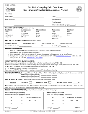
- Begin by entering the lake name in the designated field. This is essential for identifying the sampling location.
- Next, fill in the town name where the lake is located. Accurate town identification aids in data mapping.
- Input the names of field monitors involved in the sampling process. This allows tracking of participant contributions.
- Record the date of sampling in the provided field, ensuring accuracy for data analysis and reporting.
- Fill in the time of sampling. This is crucial for understanding environmental conditions at the time.
- Measure and enter the bottom depth at the deep spot of the lake in meters to support lake profile assessments.
- Indicate weather conditions by circling the correct weather descriptions for cloud cover, air temperature, and wind conditions.
- Document water surface conditions by circling the most applicable description.
- Check all precipitation conditions that apply, noting any recent rainfall that could affect water quality.
- Complete the sampling reminders section, ensuring adherence to best practices and protocols.
- Answer the volunteer training qualifications questions, providing necessary details about training received.
- Record your depth sampling data under the deep spot samples section, making sure to note all depths accurately.
- For the chlorophyll-a sample, select the method and record the starting sample depth as instructed.
- Conduct the Secchi disk transparency measurement and document readings, ensuring visibility is recorded correctly.
- If applicable, provide details about tributary samples collected during this sampling event.
- If sampling at a new location, circle 'yes' and provide all required mapping and identification details.
- Note field observations relevant to the sampling event, ensuring comprehensive data collection.
- Finally, review all entries for accuracy, then save changes, download, or print the completed form for submission.
Complete your forms online to contribute to vital lake assessment efforts.
1 Squam Lake, New Hampshire. leonie wise on Unsplash. ... 2 Lake Sunapee, New Hampshire. Linda Whitney on Unsplash. ... 3 Lake Willoughby, Vermont. ... 4 Lake Memphremagog, Vermont. ... 5 Lake Winnipesaukee, New Hampshire. ... 6 Lake Champlain, Vermont. ... 7 Deep Creek Lake, Maryland. ... 8 Lake Lure, North Carolina.
Industry-leading security and compliance
US Legal Forms protects your data by complying with industry-specific security standards.
-
In businnes since 199725+ years providing professional legal documents.
-
Accredited businessGuarantees that a business meets BBB accreditation standards in the US and Canada.
-
Secured by BraintreeValidated Level 1 PCI DSS compliant payment gateway that accepts most major credit and debit card brands from across the globe.