Loading
Get Custom Map Production.pub - Spatial Insights, Inc.
How it works
-

Open form follow the instructions
-

Easily sign the form with your finger
-

Send filled & signed form or save
How to fill out the Custom Map Production.pub - Spatial Insights, Inc. online
Filling out the Custom Map Production form from Spatial Insights, Inc. is a straightforward process designed to help you create a high-quality custom map tailored to your needs. This guide provides step-by-step instructions to ensure that you can complete the form efficiently and accurately.
Follow the steps to successfully fill out the Custom Map Production form
- Click the ‘Get Form’ button to access the Custom Map Production form and open it in your editor.
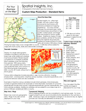
- Begin by selecting the desired base map size from the options available, which range from 8.5" x 11" to 36" x 48". Ensure you note the pricing associated with each size.
- Choose one demographic variable to be displayed on your map at no additional cost. If you wish to include more variables, note that an extra fee of $50 will apply for each additional variable.
- Indicate if you want a title, subtitle, and legend for your map. Fill in the requested fields to specify how you want these elements designed.
- If applicable, select geographical rings or areas to be included on your map, ensuring you provide details of the size or parameters needed.
- Review the turnaround time for your project. If you require expedited service, you can select the rush option for a 50% additional charge.
- After completing the order form, review all selected options for accuracy before finalizing your submission.
- Finally, save your changes, and choose to download, print, or share the form through the available options.
Start creating your custom map today by accessing the Custom Map Production form online!
Get started creating maps (Map Viewer) Choose a basemap. Add layers. Apply styles. Configure pop-ups. Save the map.
Industry-leading security and compliance
US Legal Forms protects your data by complying with industry-specific security standards.
-
In businnes since 199725+ years providing professional legal documents.
-
Accredited businessGuarantees that a business meets BBB accreditation standards in the US and Canada.
-
Secured by BraintreeValidated Level 1 PCI DSS compliant payment gateway that accepts most major credit and debit card brands from across the globe.