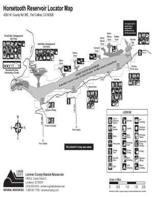
Horsetooth Reservoir Locator Map 4200 W. County Rd 38E., Fort Collins, CO 80526South Eltuck CoveInlet Bay Campground and AreaCRHorsetooth Area Information CenterInlet Bay Marinaadedn Sh VOIRke Speed.
Open form follow the instructions
Easily sign the form with your finger
Send filled & signed form or save
How to fill out the CO Horsetooth Reservoir Locator Map - Larimer County online
The CO Horsetooth Reservoir Locator Map - Larimer County provides essential information about various areas and facilities around the reservoir. This guide will assist users in effectively navigating and completing the form online with clarity and ease.
Follow the steps to fill out the CO Horsetooth Reservoir Locator Map - Larimer County online.
- Press the ‘Get Form’ button to retrieve the form, which will then open in your online editor.
- Review the map sections carefully; identify the key areas such as campgrounds, marinas, and information centers for accurate location context.
- Take note of the legend provided on the map, which indicates various features like picnic areas, restrooms, and hiking trails to understand facility locations better.
- Fill in any required personal information if applicable, while ensuring that your entries are accurate and complete.
- Once you have filled out all pertinent sections of the form, review your entries for clarity and correctness.
- Finally, save your changes; you may choose to download, print, or share the completed document as needed.
Complete your forms online for a streamlined experience.
Experience a faster way to fill out and sign forms on the web. Access the most extensive library of templates available.
Related content
Horsetooth Reservoir requires entrance and camping permits, and is open year round. It's...
[LANC2] Larimer County Landfill [2011-] ... If so, please consider submitting a location...
Voting Locations · Wildfire Maps · Zoning Maps. Larimer County Webcams. Devil's...
Get answers to your most pressing questions about US Legal Forms API.
Do you need a reservation for Horsetooth Reservoir?
This facility offers campsites/day use sites. Effective November 2021: Daily Entrance Permits can be purchased online with a camping reservation.
Where is Horsetooth Reservoir located?
Horsetooth Reservoir requires entrance and camping permits, and is open year round. It's located west of Fort Collins, Colorado, at an elevation of 5,420 feet.
Do you have to pay to hike at Horsetooth?
Horsetooth Mountain Open Space charges a fee to enter. For more information, please visit: https://.larimer.org/naturalresources/parks/horsetooth-mountain • SEASONAL CLOSURE: This area is subject to seasonal closure due to weather or muddy conditions.
Do I need a pass for Horsetooth Reservoir?
Horsetooth Reservoir requires entrance and camping permits, and is open year round.
How much does it cost to park in Horsetooth?
Daily Entrance Permits Carter Lake, Flatiron, Pinewood and Horsetooth reservoirs$10/vehicle or $10/boat trailer only, or $20/vehicle and boat trailerHorsetooth Mountain, Blue Sky Trail, Hermit Park, Ramsay-Shockey Open Space, and new in 2022 - Devil's Backbone Open Space$10/vehicle
What town is at the bottom of Horsetooth Reservoir?
Yes, there was a Colorado town by the name of Stout. It no longer exists and the site of it is under Horsetooth Reservoir near Fort Collins. It derived its income from sandstone quarries during the 1880s and 1890s. Many of the sidewalks in Denver, Omaha and Lincoln were made of Stout sandstone.
Is there free parking at Horsetooth Reservoir?
** All vehicles must have a Horsetooth parking pass, you can either purchase a single day permit for $9 or buy the annual pass, $90 for residents or $120 for non-residents. Entrance permits are required for all park use and the revenue generated from permit sales goes directly back into our parks and open spaces.
How deep is the deepest part of Horsetooth Reservoir?
Horsetooth Reservoir supllies Fort Collins with half of its water supply. When the reservoir is full, it is 6.5 miles long and 203 feet deep at its deepest point. Located in Lory State Park, which contains 2,400 acres and 25 miles of trails. The hike is a moderate 6-mile journey with a scramble to the very top.
Use professional pre-built templates to fill in and sign documents online faster. Get access to thousands of forms.
If you believe that this page should be taken down, please follow our DMCA take down process here.