Loading
Get Gis Llcf-015 2021-2026
How it works
-

Open form follow the instructions
-

Easily sign the form with your finger
-

Send filled & signed form or save
How to fill out the GIS LLCF-015 online
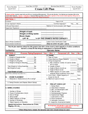
The GIS LLCF-015 form is essential for planning and executing crane lifts to ensure safety and compliance with operational standards. This guide provides step-by-step instructions for filling out the form online, assisting users in navigating each section effectively.
Follow the steps to complete the GIS LLCF-015 form.
- Click the ‘Get Form’ button to access the GIS LLCF-015 and open it in your preferred online editor.
- Begin by completing Section 1 of the form. Enter the date of the lift, location, and the name of the crane operator. Indicate whether they are a certified GIS operator by marking 'Yes' or 'No'.
- Provide a detailed description of the lift/load and specify the method of communication with the rigger. Include the supervisor's signature and fill in the weight of the load, lifting tackle, and boom angle.
- Indicate the lift as a percentage of the crane's rated capacity and describe the sea and wave conditions, as well as environmental conditions.
- If the lift is greater than 50% of the crane’s rated capacity or conditions warrant a critical lift, proceed to Section 2. Here, provide the weights of various components including process piping/equipment, headache ball, block, lifting bar, slings, and shackles.
- Specify the type of crane, maximum rated capacity, lifting arrangement details such as the maximum distance from the load center to the crane, and angles of the boom.
- Detail the sizing of slings, including the number of slings, type of configuration, and rated capacities. Record any special instructions or restrictions related to the crane or rigging.
- Complete the pre-lift checklist items, confirming each essential aspect has been addressed.
- After filling the form, save your changes. You can choose to download, print, or share the completed form as needed.
Complete your GIS LLCF-015 form online to ensure a safe and compliant lifting operation.