Loading
Get Usace Wetland Determination Data Form
How it works
-

Open form follow the instructions
-

Easily sign the form with your finger
-

Send filled & signed form or save
How to fill out the USACE Wetland Determination Data Form online
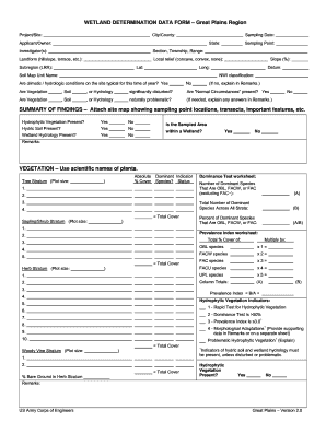
The USACE Wetland Determination Data Form is essential for assessing wetland areas in compliance with regulations. This guide provides step-by-step instructions to help users complete the form accurately and efficiently online.
Follow the steps to fill out the form online.
- Press the ‘Get Form’ button to obtain the form and open it in your preferred online editor.
- Fill in the City/County and Project/Site fields to identify the location of the wetland determination. Enter the date of sampling in the Sampling Date field and select the State from the provided options.
- Provide the Applicant/Owner's name and the names of the Investigator(s) involved in the assessment. Include the Section, Township, and Range to specify the property details.
- Describe the Landform by selecting options such as hillslope or terrace. Then, indicate the Sampling Point and local relief (concave, convex, none) and provide the geographic coordinates of the site (Lat/Long).
- Document the Subregion, slope percentage, and Datum. Fill out the NWI classification accordingly.
- Answer questions regarding climatic and hydrologic conditions on the site, using Yes or No options. If necessary, provide explanations in the Remarks section.
- Evaluate whether vegetation, soil, or hydrology is significantly disturbed, and check if 'Normal Circumstances' are present. Provide explanations if needed.
- Complete the summary of findings, including checking if Hydrophytic Vegetation, Hydric Soil, and Wetland Hydrology are present. Indicate if the sampled area is within a wetland.
- Proceed with filling out the Vegetation section, using scientific names for plants and detailing data for tree, sapling/shrub, and herb strata. Complete the dominance tests and prevalence index calculations.
- In the Soil section, provide a profile description and details for each depth layer, noting matrix color and any redox features present.
- Detail the Hydrology indicators by checking the relevant primary and secondary indicators. Document observations regarding the surface water and wetland hydrology.
- Finally, review all entries for accuracy. Save your changes, and you may download, print, or share the completed form as necessary.
Complete the USACE Wetland Determination Data Form online today to streamline your wetland assessment process!
Determining a wetland involves evaluating soil, vegetation, and hydrology using established criteria. This assessment is essential for compliance with environmental laws and planning purposes. Utilizing the USACE Wetland Determination Data Form simplifies this process, allowing you to gather the necessary data systematically and efficiently.