Loading
Get Ohwm Delineation Cover Sheet Page Of - Erdc Usace Army
How it works
-

Open form follow the instructions
-

Easily sign the form with your finger
-

Send filled & signed form or save
How to fill out the OHWM Delineation Cover Sheet Page Of - Erdc Usace Army online
The OHWM Delineation Cover Sheet is a crucial document for accurately delineating the ordinary high-water mark for streams and rivers. This guide will provide you with a step-by-step approach to completing this form online, ensuring all necessary information is captured effectively.
Follow the steps to fill out the OHWM delineation cover sheet online.
- Click ‘Get Form’ button to obtain the form and open it in the editor.
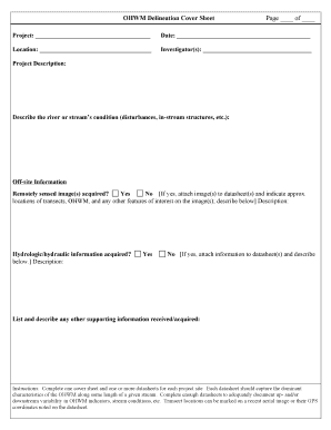
- Once the form is open, start by entering the project name in the designated field labeled 'Project'. You must provide a clear and specific title that accurately reflects the project.
- Next, fill in the 'Date' field with the current date. Ensure the format aligns with any specified guidelines.
- Provide the 'Location' of the project site, which should be as detailed as possible to facilitate the understanding of the geographical context.
- In the 'Investigator(s)' section, list the names of the individuals conducting the study. Include all relevant personnel involved in the project.
- For the 'Project Description', succinctly describe the river or stream’s condition. Note any disturbances or in-stream structures relevant to the site.
- For Off-site Information, indicate whether remotely sensed images were acquired by selecting 'Yes' or 'No'. If 'Yes', attach the images to the datasheets and describe location details.
- In the hydrologic/hydraulic information section, similarly select 'Yes' or 'No'. If 'Yes', make sure to attach the relevant information and provide a description.
- List and describe any other supporting information you have received or acquired that will aid in the delineation process.
- Complete one cover sheet and ensure that you attach one or more datasheets for the project site that encapsulate the dominant characteristics of the ordinary high-water mark.
- Before finalizing, review all entered information for accuracy. Ensure that you've recorded enough data to represent any upstream or downstream variations in conditions.
- Once satisfied with the completed form, you can save changes, download, print, or share the form as needed.
Complete your OHWM delineation cover sheet online today for accurate project documentation!
Ordinary High Water Mark and Low Water Datum - Table Of Values LocationDatumOHWM (feet)Point Aux FrenesIGLD 1985582.0De Tour PassageIGLD 1985581.9Lake MichiganIGLD 1985581.5Lake HuronIGLD 1985581.541 more rows
Industry-leading security and compliance
US Legal Forms protects your data by complying with industry-specific security standards.
-
In businnes since 199725+ years providing professional legal documents.
-
Accredited businessGuarantees that a business meets BBB accreditation standards in the US and Canada.
-
Secured by BraintreeValidated Level 1 PCI DSS compliant payment gateway that accepts most major credit and debit card brands from across the globe.